

Togian Isles to Peleng Strait
Stanford University Libraries
Stanford Libraries SearchWorks

Peleng Strait to Tomori Gulf
Stanford University Libraries
Stanford Libraries SearchWorks
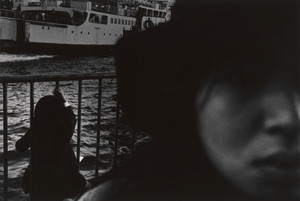
Ferryboats, Tsugaru Strait
Museum of Modern Art, New York
The Museum of Modern Art (MoMA) Collection

Cook Strait, New Zealand
Museum of New Zealand Te Papa Tongarewa
DigitalNZ New Zealand API

Bass Strait, Table Cape
Museum of Fine Arts, Houston
Museum of Fine Arts, Houston

Japan, Kyūshū--south coast : approaches to Osumi Kaikyo (Van Diemen Strait) (Eastern part)
Stanford University Libraries
Stanford Libraries SearchWorks

Asia, Japan--South Korea, Korea Strait to Tōkyō-Wan, including Shikoku and Kyūshū [electronic reso...
Stanford University Libraries
Stanford Libraries SearchWorks

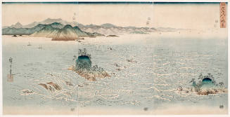
Strait of Naruto in Awa Province
Freer and Sackler
DPLA API
The Rapids of Naruto Strait in Awa (Awa Naruto no Fūkei)
Honolulu Museum of Art
Honolulu Museum of Art Collection
The Taiwan Dilemma: China, Japan, and the strait dynamic
GESIS - Leibniz-Institut für Sozialwissenschaften. Bibliothek Köln
Europeana API
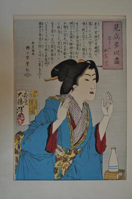
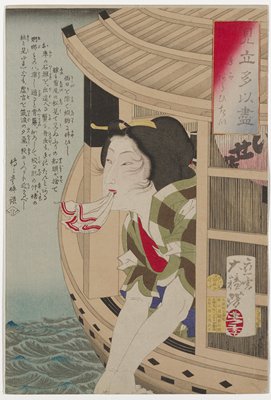
Somehow I Want to Win
Minneapolis Institute of Arts
Minneapolis Institute of Art API
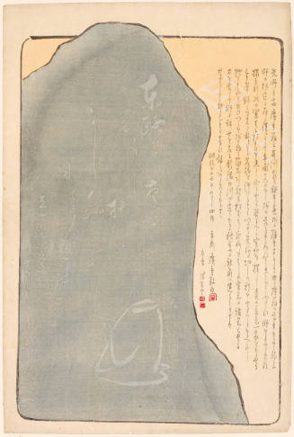
Monument to Hiroshige I
Honolulu Museum of Art
Honolulu Museum of Art Collection
To kvinner i vogn
Norwegian Museum of Science and Technology
Europeana API

I Want to Win Somehow (Dōka kachitai)
Philadelphia Museum of Art
Philadelphia Museum of Art collection
Asia, China--Tʻai-wan--Philippines--Japan, Luzon Strait [electronic resource]
Stanford University Libraries
Stanford Libraries SearchWorks
Index to Admiralty charts of Nakai or Inland Sea, Korea Strait, Okhotsk Sea, Kamchatka and Peter the Great Bay / Hydrographic Office
National Library of Australia
Trove: National Library of Australia

Eastern Archipelago : Flores Sea. Tana Jampea and Adjacent Islands
Stanford University Libraries
Stanford Libraries SearchWorks
33.1: Visitors to I Corps
NDL Digital Collections
NDL Digital Collections

The Whirlpools in Naruto Strait, Awa Province (Awa Naruto no fukei)
Art Institute of Chicago
Art Institute of Chicago API

I want to cancel my subscription
Minneapolis Institute of Arts
Minneapolis Institute of Art API

I Want to Start My Performance
Philadelphia Museum of Art
Philadelphia Museum of Art collection
I want to wash my hands
Minneapolis Institute of Arts
Minneapolis Institute of Art API

I Want to See His Face
Philadelphia Museum of Art
Philadelphia Museum of Art collection

Then, I Decided to Give a Tour of Tokyo to the Octopus from Akashi
Museum of Fine Arts, Houston
Museum of Fine Arts, Houston

Northern Approaches to Makassar
Stanford University Libraries
Stanford Libraries SearchWorks

Approach to West Coast of Gazelle Peninsula
Stanford University Libraries
Stanford Libraries SearchWorks

Central Portion of Sumbawa with Pulo Tenga Islands
Stanford University Libraries
Stanford Libraries SearchWorks

Hermit Islands
Stanford University Libraries
Stanford Libraries SearchWorks

Plans of Anchorages in Tomori Gulf and Adjacent Coast
Stanford University Libraries
Stanford Libraries SearchWorks

New Guinea - South Coast. Freshwater Bay to C. Blackwood
Stanford University Libraries
Stanford Libraries SearchWorks

Straits between Sumbawa, Flores and Sumba
Stanford University Libraries
Stanford Libraries SearchWorks

New Guinea - N. E. Coast. C. Ward Hunt to C. Nelson
Stanford University Libraries
Stanford Libraries SearchWorks

Japan : political divisions / Board of Economic Warfare ; drawn in R and A, OSS
Yale University Library
Yale University Library Digital Collections
Peleng Strait to Tomori Gulf
Stanford University Libraries
Stanford Libraries SearchWorks

Asia : Coast of China : Ryōtō Kaiwan. Approaches to Ryō Ga Entrance
Stanford University Libraries
Stanford Libraries SearchWorks

Rice areas in Japan
Stanford University Libraries
Stanford Libraries SearchWorks

Australia : Coral Sea and Great Barrier Reefs. Sheet 2
Stanford University Libraries
Stanford Libraries SearchWorks

Carta General Para Las Navegaciones a la India Oriental Por El Mar Del Sur Y el grande Oceano que ...
Stanford University Libraries
Stanford Libraries SearchWorks

Western Portions of Flores
Stanford University Libraries
Stanford Libraries SearchWorks

Ryōtō Kaiwan : Daitzu Shan to Fuchou Chao
Stanford University Libraries
Stanford Libraries SearchWorks

Carte des decouvertes, faites en 1787 dans les mers de Chine et de Tartarie par les Fregates Franc...
Stanford University Libraries
Stanford Libraries SearchWorks
![Sanjūmanbun no ichi Shina engan rikukai hengōzu [cartographic material]](https://stacks.stanford.edu/image/iiif/cn019rx5665%2Fcn019rx5665_00_0001/full/!200,200/0/default.jpg)
Sanjūmanbun no ichi Shina engan rikukai hengōzu [cartographic material]
Stanford University Libraries
Stanford Libraries SearchWorks

Plans on the West Coast of Celebes
Stanford University Libraries
Stanford Libraries SearchWorks

South Pacific Ocean, British New Guinea - South Coast. Orangerie Bay to Round Head
Stanford University Libraries
Stanford Libraries SearchWorks

Futsuryō Indoshina Gojūmanbunnoichi Zu = Carte de l'Indochine
Stanford University Libraries
Stanford Libraries SearchWorks

Carta General Para Las Navegaciones a la India Oriental Por El Mar Del Sur Y el grande Oceano que ...
Stanford University Libraries
Stanford Libraries SearchWorks
Carta General Para Las Navegaciones a la India Oriental Por El Mar Del Sur Y el grande Oceano que ...
Stanford University Libraries
Stanford Libraries SearchWorks

Yōzu (kūchū shashin sokuryō) Mōko jūmanbun no ichizu
Stanford University Libraries
Stanford Libraries SearchWorks
Last Updated: 2020-04-17
Uploaded: 2021-09-21