

Togian Isles to Peleng Strait
Stanford University Libraries
Stanford Libraries SearchWorks

Salayar Strait to Tana Keke I.
Stanford University Libraries
Stanford Libraries SearchWorks
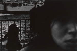
Ferryboats, Tsugaru Strait
Museum of Modern Art, New York
The Museum of Modern Art (MoMA) Collection

Cook Strait, New Zealand
Museum of New Zealand Te Papa Tongarewa
DigitalNZ New Zealand API

Bass Strait, Table Cape
Museum of Fine Arts, Houston
Museum of Fine Arts, Houston

Asia, Japan--South Korea, Korea Strait to Tōkyō-Wan, including Shikoku and Kyūshū [electronic reso...
Stanford University Libraries
Stanford Libraries SearchWorks

Japan, Kyūshū--south coast : approaches to Osumi Kaikyo (Van Diemen Strait) (Eastern part)
Stanford University Libraries
Stanford Libraries SearchWorks
The Taiwan Dilemma: China, Japan, and the strait dynamic
GESIS - Leibniz-Institut für Sozialwissenschaften. Bibliothek Köln
Europeana API

Strait of Naruto in Awa Province
Freer and Sackler
DPLA API

Japan, Gulf of Ösaka, Hiogo and Ösaka compiled from British and French surveys to 1878
Boston Public Library
DPLA API

China—Gulf of Pohai (Pechili) : Lungkow Bay
Stanford University Libraries
Stanford Libraries SearchWorks
Japan Islands and eastern coasts of Korea and Siberia from Tsu Sima to Gulf of Tartary : index to Admiralty published charts / Hydrographic Office
National Library of Australia
Trove: National Library of Australia
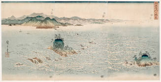
The Rapids of Naruto Strait in Awa (Awa Naruto no Fūkei)
Honolulu Museum of Art
Honolulu Museum of Art Collection
Index to Admiralty charts of Nakai or Inland Sea, Korea Strait, Okhotsk Sea, Kamchatka and Peter the Great Bay / Hydrographic Office
National Library of Australia
Trove: National Library of Australia
Persian Gulf war adds wrinkle to 386 chip shortage for Intel. (Intel Corp.)
Trove: National Library of Australia

Plans of Anchorages in Tomori Gulf and Adjacent Coast
Stanford University Libraries
Stanford Libraries SearchWorks
Asia, China--Tʻai-wan--Philippines--Japan, Luzon Strait [electronic resource]
Stanford University Libraries
Stanford Libraries SearchWorks

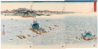
The Whirlpools in Naruto Strait, Awa Province (Awa Naruto no fukei)
Art Institute of Chicago
Art Institute of Chicago API

Japan : South coast of Honshu : Gulf of Tokyo or Yedo. Compiled from Japanese Government, and Brit...
Stanford University Libraries
Stanford Libraries SearchWorks
View of Naruto Strait in Awa Province, series Triptychs of Snow
Honolulu Museum of Art
Honolulu Museum of Art Collection
Asia, China--South Korea--Japan, Yellow Sea, including the East China Sea and Korea Strait [electr...
Stanford University Libraries
Stanford Libraries SearchWorks
Unidentified men pulling in net on board Japanese fishing boat, Cook Strait
Alexander Turnbull Library
DigitalNZ New Zealand API
Fish being measured by unidentified man on board Japanese fishing boat, Cook Strait
Alexander Turnbull Library
DigitalNZ New Zealand API

Ōgi to inrō
Library of Congress
Digital Collections, Library of Congress

Western Portions of Flores
Stanford University Libraries
Stanford Libraries SearchWorks

Approach to West Coast of Gazelle Peninsula
Stanford University Libraries
Stanford Libraries SearchWorks

Australia : Coral Sea and Great Barrier Reefs. Sheet 2
Stanford University Libraries
Stanford Libraries SearchWorks

Carta General Para Las Navegaciones a la India Oriental Por El Mar Del Sur Y el grande Oceano que ...
Stanford University Libraries
Stanford Libraries SearchWorks
Carta General Para Las Navegaciones a la India Oriental Por El Mar Del Sur Y el grande Oceano que ...
Stanford University Libraries
Stanford Libraries SearchWorks

Carte Des Cotes De L'Amerique Et De L'Asie depuis la Californie jusqu'a Macao . . . 1786 et 1787 ....
Stanford University Libraries
Stanford Libraries SearchWorks

New Guinea - South Coast. Freshwater Bay to C. Blackwood
Stanford University Libraries
Stanford Libraries SearchWorks

Rongorapputō fukin
Stanford University Libraries
Stanford Libraries SearchWorks

Central Portion of Sumbawa with Pulo Tenga Islands
Stanford University Libraries
Stanford Libraries SearchWorks

Orientation: Philippines to Japan / R & A, OSS
Yale University Library
Yale University Library Digital Collections
![Taiheiyō shotō yochizu [cartographic material] : Roppyakumanbun no ichi](https://stacks.stanford.edu/image/iiif/td070bz1257%2Ftd070bz1257_00_0001/full/!200,200/0/default.jpg)
Taiheiyō shotō yochizu [cartographic material] : Roppyakumanbun no ichi
Stanford University Libraries
Stanford Libraries SearchWorks

Eastern Portion of Flores to Lomblem
Stanford University Libraries
Stanford Libraries SearchWorks

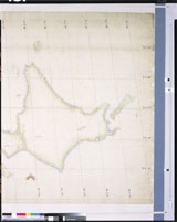
Ryukyu Islands roads, railroads and cables
Stanford University Libraries
Stanford Libraries SearchWorks

North Pacific Ocean : Eastern Part of Hawaiin Islands
Stanford University Libraries
Stanford Libraries SearchWorks
Togian Isles to Peleng Strait
Stanford University Libraries
Stanford Libraries SearchWorks

Campbell's Fahrt von Sannack nach Kodiak und Lage jener Inseln . . . 1817
Stanford University Libraries
Stanford Libraries SearchWorks

Chart of Discoveries made in 1787, in the Seas of China and Tartary, by the Boussole and Astrolabe...
Stanford University Libraries
Stanford Libraries SearchWorks

Japan : political divisions / Board of Economic Warfare ; drawn in R and A, OSS
Yale University Library
Yale University Library Digital Collections
Salayar Strait to Tana Keke I.
Stanford University Libraries
Stanford Libraries SearchWorks

Straits between Sumbawa, Flores and Sumba
Stanford University Libraries
Stanford Libraries SearchWorks

Japan. Re- Published, Jany st. 1845, by G.F. Cruchley, Mapseller, 81 Fleet Street, London. (to acc...
Stanford University Libraries
Stanford Libraries SearchWorks
日本国図(日本沿海輿地図(小図))
Tokyo National Museum
ARC Ukiyo-e Portal Database

Japan, Manchuria, and adjacent regions
Stanford University Libraries
Stanford Libraries SearchWorks
![Orientation, Philippines to Japan [cartographic material]](https://stacks.stanford.edu/image/iiif/nh916xd2027%2Fnh916xd2027_00_0001/full/!200,200/0/default.jpg)
Orientation, Philippines to Japan [cartographic material]
Stanford University Libraries
Stanford Libraries SearchWorks
Last Updated: 2020-04-17
Uploaded: 2021-09-21