
New Guinea - South-East Coast. Approaches to Dedele
- Time
- Owner Organization

Pacific Ocean, Approaches to south east part of New Guinea

New Guinea - South Coast. Freshwater Bay to C. Blackwood

South Pacific Ocean, British New Guinea - South Coast. Orangerie Bay to Round Head

Japan, Kyūshū--south coast : approaches to Osumi Kaikyo (Van Diemen Strait) (Eastern part)

China - east coast : Hangchow Wan - southeast portion : including the approaches to the Yung Kiang

New Guinea - N. E. Coast. C. Ward Hunt to C. Nelson

Plans on the north-eastern coast of New Guinea

Plans in south eastern part of New Guinea

Plans in the south-eastern part of New Guinea

JAPANESE TRAPPED IN MILNE BAY AREA: ALLIES' SOUTH-EAST NEW GUINEA SUCCESS

Asia : Coast of China : Ryōtō Kaiwan. Approaches to Ryō Ga Entrance
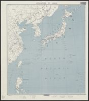
Approaches to Japan

Ise Bay - North :

Oshima, south coast of Japan

West Coast of Korea. Approaches to Séoul : with Sir James Hall Group and Ta-Tong River

Japan, Hokushu _ West Coast. Iwanai Byochi and Approaches

Approach to West Coast of Gazelle Peninsula

Eastern Archipelago : Celebes - East Coast. Tg. Losoni to Northern Entrance to Buton Str.

A Generall Chart of the South Sea from the River of Plate to Dampiers Streights on ye Coast of New...

South Pacific Ocean : New Hebrides Is. North Coast of Aneityum Island showing Port Patrick, Ijipth...

Habu Ko : Japan south coast O Shima

When East Asia meets Europe :Explaining the differential approaches of South Korea and Japan towar...
South Pacific - Fiji - Rifle drill for New Zealand soldiers on the coast of Viti Levu

Northern Approaches to Makassar
Plans in south eastern part of New Guinea
New Guinea - N. E. Coast. C. Ward Hunt to C. Nelson

Durville Island and Approaches

Carte De L'Oceanie Contenant L'Australe, La Polynesie et Les Iles Asiatique [Australia called Nota...

Plans of Anchorages in Witu Islands
Plans on the north-eastern coast of New Guinea
![Tōbu nyūginia fon hantō oyobi madan chiku heiyō chishi shiryōzu [cartographic material]](https://stacks.stanford.edu/image/iiif/ns225gy7512%2Fns225gy7512_00_0001/full/!200,200/0/default.jpg)
Tōbu nyūginia fon hantō oyobi madan chiku heiyō chishi shiryōzu [cartographic material]

Descripcion De Las Yndias Ocidentales

Eastern Archipelago : Flores Sea. Tana Jampea and Adjacent Islands
Pacific Ocean, Approaches to south east part of New Guinea

Jūmanbunnoichi Guamutō fukin

Ichimanbun no ichi chikeizu Yokohama kinbō

Eastern Archipelago. Flores and Timor Seas
Plans in the south-eastern part of New Guinea

Imperium Japonicum in sexaginta et octo provincias divisum : Ex ipsorum Japonensium mappis & obser...

Proposed plan of Ujigawa denki kabushiki kwai-sha : From Nango, Ishiyama-Mura, Shiga Prefecture, t...
![Kure [cartographic material] : plan of port and naval establishments](https://stacks.stanford.edu/image/iiif/rk636yd7844%2Frk636yd7844_0001/full/!200,200/0/default.jpg)
Kure [cartographic material] : plan of port and naval establishments
Japanse schildering van krijgsactie
South Pacific Ocean, British New Guinea - South Coast. Orangerie Bay to Round Head
Japan, Kyūshū--south coast : approaches to Osumi Kaikyo (Van Diemen Strait) (Eastern part)

Rand, McNally & Company's indexed atlas of the world map of Japan Copyright 1892, by Rand, McNally...

Novus Orbis potius Altera Continens Atlantis Insula a Nicaloa Sanson Antiquitati Restituta . . . 1...

Imperii Sinarum Nova Descriptio

Japanese painting
Last Updated: 2020-04-17
Uploaded: 2021-09-21