
Japan, Hokushu - South Coast. Uchiura Wan or Iburi Wan (Volcano Bay)
- Time
- Owner Organization

Ise Bay - North :
Yale University Library
Yale University Library Digital Collections

Japan: Kyushu East Coast: Ariake Wan
Monash University Library
Trove: National Library of Australia

Oshima, south coast of Japan
Royal Museums Greenwich
Europeana API

Japan, North Coast of Hokushu. Wakkanai Ko
Stanford University Libraries
Stanford Libraries SearchWorks

New Guinea - South Coast. Freshwater Bay to C. Blackwood
Stanford University Libraries
Stanford Libraries SearchWorks

Japan : South coast of Honshu : Gulf of Tokyo or Yedo. Compiled from Japanese Government, and Brit...
Stanford University Libraries
Stanford Libraries SearchWorks

Japan, Hokushu _ West Coast. Iwanai Byochi and Approaches
Stanford University Libraries
Stanford Libraries SearchWorks

Habu Ko : Japan south coast O Shima
Monash University Library
Trove: National Library of Australia

Japan, Hokkaido (Yezo) West Coast. Furubira Wan to Aikappu Misaki
Stanford University Libraries
Stanford Libraries SearchWorks

South Pacific Ocean, British New Guinea - South Coast. Orangerie Bay to Round Head
Stanford University Libraries
Stanford Libraries SearchWorks

Japan, Kyūshū--south coast : approaches to Osumi Kaikyo (Van Diemen Strait) (Eastern part)
Stanford University Libraries
Stanford Libraries SearchWorks

Hiroshima Ko (Ujina Ko) : Japan Naikai or Inland Sea Hiroshima Wan
Monash University Library
Trove: National Library of Australia

Hiroshima Wan : Japan Naikai or Inland Sea Aki Nada
Monash University Library
Trove: National Library of Australia
Part of Japan or Nippon [east coast of Honshu Island, Japan] / T. Bowen, sct
National Library of Australia
Trove: National Library of Australia
![Japan, northeastern coast of Honshū and southern Hokkaidō [electronic resource]](https://www.gumtree.com/static/1/resources/assets/rwd/images/orphans/a37b37d99e7cef805f354d47.noimage_thumbnail.png)
Japan, northeastern coast of Honshū and southern Hokkaidō [electronic resource]
Stanford University Libraries
Stanford Libraries SearchWorks
Asia, Japan--South Korea, Korea Strait to Tōkyō-Wan, including Shikoku and Kyūshū [electronic reso...
Stanford University Libraries
Stanford Libraries SearchWorks

South Pacific Ocean : New Hebrides Is. North Coast of Aneityum Island showing Port Patrick, Ijipth...
Stanford University Libraries
Stanford Libraries SearchWorks

Japan-Yezo Id., e. coast, Akishi Bay republished from the Brt. Admty. chart no. 992, corrected to 1873
Boston Public Library
DPLA API

Part of Japan or Nipon. (with) View of the coast of Japan when we first saw it (Engraved by) W. H(...
Stanford University Libraries
Stanford Libraries SearchWorks

日本本州北西岸能登七尾湾= Japan Honshū, N. W. coast, Nanao Bay : north bay from survey of Lieutt. K. Kimotski, I. J. N. 12th. Year of Meiji (1879), South Bay, West Bay and the Soundings at outer part of the Bays from survey of commr. K. Isono
Yoshida-South Library, Kyoto University
IIIF Discovery in Japan
A chart of the northern part of the China Sea shewing the passage from Formosa to Japan : with the eastern coast of China and the Lekeyo Islands
National Library of Australia
Trove: National Library of Australia

Japan. Carte 42. Dresse par G. Bagge et D. Aitoff. Imp. Dufrenoy 12-35 Librarie Hachette. Grave pa...
Stanford University Libraries
Stanford Libraries SearchWorks

「高雄山全図」
C. V. Starr East Asian Library, University of California, Berkeley
ARC Ukiyo-e Portal Database
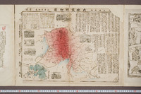
美濃尾張大地震明細図
University of Tokyo General Library
UTokyo Academic Archives Portal

酒田市最新明細地図
個人蔵
ADEAC: A System of Digitalization and Exhibition for Archive Collections

City plan of Kōbe.
Stanford University Libraries
Stanford Libraries SearchWorks
「富士三十六景」 「武蔵たま川」
National Diet Library, Japan
ARC Ukiyo-e Portal Database

Eastern Archipelago. Sumba or Sandelhout
Stanford University Libraries
Stanford Libraries SearchWorks

北海道の観光と交通
国際日本文化研究センター
IIIF Discovery in Japan
皇国二十四功(収載資料名:錦絵帖)
National Diet Library, Japan
ARC Ukiyo-e Portal Database

参詣要覧身延山圖繪
国際日本文化研究センター
IIIF Discovery in Japan
![[歴民カード_歴史] 婦人拝み図絵馬](https://khirin-i.rekihaku.ac.jp/iiif/nmjh_rekimin_h/10748023_02.tif/full/200,/0/default.jpg)
[歴民カード_歴史] 婦人拝み図絵馬
National Museum of Japanese History
IIIF Discovery in Japan

Southwest Japan (Kyūshū, Shikoku, and southwest Honshū), railroads and railroad facilities [cartog...
Stanford University Libraries
Stanford Libraries SearchWorks

「関取道中之図」 「剱山」
National Diet Library, Japan
ARC Ukiyo-e Portal Database

Southwest Japan (Kyūshū, Shikoku, and southwest Honshū), railroads and railroad facilities [cartog...
Stanford University Libraries
Stanford Libraries SearchWorks
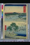
「名所江戸百景」 「両国船中浅草遠景」
National Diet Library, Japan
ARC Ukiyo-e Portal Database
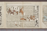
安政二乙卯歳十月二日夜ル四ツ時震始メ末代
University of Tokyo General Library
UTokyo Academic Archives Portal
義士四拾七人之内(収載資料名:錦絵)
National Diet Library, Japan
ARC Ukiyo-e Portal Database

「武蔵名所調布多摩川」
National Diet Library, Japan
ARC Ukiyo-e Portal Database

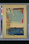
「東海道五拾三次之内」「大津」「走井茶店」
Tokyo Metropolitan Central Library
ARC Ukiyo-e Portal Database

「江戸名所道外尽」「十二」 「洲崎の汐干」
National Diet Library, Japan
ARC Ukiyo-e Portal Database
![[歴民カード_歴史] 明治年間元圦樋管伏替図](https://khirin-i.rekihaku.ac.jp/iiif/nmjh_rekimin_h/11147036_02.tif/full/200,/0/default.jpg)
[歴民カード_歴史] 明治年間元圦樋管伏替図
National Museum of Japanese History
IIIF Discovery in Japan

Ichimanbun no ichi Toyohara kinbō
Stanford University Libraries
Stanford Libraries SearchWorks

Japan. Pergamon World Atlas. Pergamon Press, Ltd. & P.W.N. Poland 1967. Sluzba Topograficzna W.P
Stanford University Libraries
Stanford Libraries SearchWorks
![[歴民カード_歴史] 紙本金地著色住吉神社・四天王寺図屏風](https://khirin-i.rekihaku.ac.jp/iiif/nmjh_rekimin_h/12747007_02.tif/full/200,/0/default.jpg)
[歴民カード_歴史] 紙本金地著色住吉神社・四天王寺図屏風
National Museum of Japanese History
IIIF Discovery in Japan
Last Updated: 2020-04-17
Uploaded: 2021-09-21