
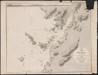
Japan, Hokkaido (Yezo) West Coast. Furubira Wan to Aikappu Misaki
- Time
- Owner Organization

Japan Series: Hokkaido - Furubira
Museum of New Zealand Te Papa Tongarewa
DigitalNZ New Zealand API
![Karia [Kariya], west coast of Japan](https://api.europeana.eu/api/v2/thumbnail-by-url.json?uri=http%3A%2F%2Fcollections.rmg.co.uk%2FmediaLib%2F537%2Fmedia-537366%2Flarge.jpg&type=IMAGE)
Karia [Kariya], west coast of Japan
Royal Museums Greenwich
Europeana API

Celebes - West Coast : Cape William to Tandyung Karang
Stanford University Libraries
Stanford Libraries SearchWorks

Japan, Hokushu _ West Coast. Iwanai Byochi and Approaches
Stanford University Libraries
Stanford Libraries SearchWorks

Approach to West Coast of Gazelle Peninsula
Stanford University Libraries
Stanford Libraries SearchWorks

Japan, Hokushu - South Coast. Uchiura Wan or Iburi Wan (Volcano Bay)
Stanford University Libraries
Stanford Libraries SearchWorks

Ise Bay - North :
Yale University Library
Yale University Library Digital Collections

Furubira fish market, Shakotan Peninsula, Hokkaido, Japan. Taken for a series on Japan for ‘Life’
Museum of New Zealand Te Papa Tongarewa
DigitalNZ New Zealand API

Japan-Yezo Id., e. coast, Akishi Bay republished from the Brt. Admty. chart no. 992, corrected to 1873
Boston Public Library
DPLA API
Japan Kiusiu Island, West Coast. Nagasaki Harbour, 1861 / engraved by Davies & Powell
Yale University Library
Yale University Library Digital Collections

Amazing invasion map : Jap plan to seize the West Coast : Pictorial review. Seattle Post - Intelli...
Stanford University Libraries
Stanford Libraries SearchWorks

(Map of Hokkaido, Japan). (to accompany) Shomitsu Nippon chizu. (Atlas of Japan) Nippon Shoin. (To...
Stanford University Libraries
Stanford Libraries SearchWorks

West Coast of Korea. Approaches to Séoul : with Sir James Hall Group and Ta-Tong River
Stanford University Libraries
Stanford Libraries SearchWorks

(Hokkaido 1). (to accompany) Shomitsu Nippon chizu. (Atlas of Japan). Nippon Shoin (Tokyo, 1956)
Stanford University Libraries
Stanford Libraries SearchWorks

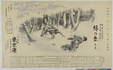
Fisherman rowing out to fish in the snowstorm, in northern district in Japan, along the coast of the Japan Sea
Minneapolis Institute of Arts
Minneapolis Institute of Art API

The rear defences of the hill to the N. of the Tseszetai forts, on the W. Coast of Wei-Hai-Wei
Rijksmuseum
Europeana API
A new chart of the Pacific Ocean : exhibiting the western coast of America, from Cape Horn to Beerings Strait, the eastern shores of Asia including Japan, China and Australia and all the numerous islands and known dangers situated in Polynesia and Australasia / correctly drawn and regulated according to the most approved and modern surveys and astronomical observations by J.W. Norie
State Library of New South Wales
Trove: National Library of Australia

Nyūjōjiatō fukin sozu
Stanford University Libraries
Stanford Libraries SearchWorks
![Taihokufu fukinzu [cartographic material]](https://stacks.stanford.edu/image/iiif/hq090pr2850%2Fhq090pr2850_00_0001/full/!200,200/0/default.jpg)
Taihokufu fukinzu [cartographic material]
Stanford University Libraries
Stanford Libraries SearchWorks
Tsurukame、oukan
Shochiku Otani Library
ARC Banzuke (Playbills) Portal Database
Japan, Hokushu _ West Coast. Iwanai Byochi and Approaches
Stanford University Libraries
Stanford Libraries SearchWorks
![America Bay [cartographic material]](https://stacks.stanford.edu/image/iiif/nj035cf2832%2Fnj035cf2832_00_0001/full/!200,200/0/default.jpg)
America Bay [cartographic material]
Stanford University Libraries
Stanford Libraries SearchWorks
Ranyō Nyūginia zenzu
National Library of Australia
Trove: National Library of Australia
Midorinoito
Shochiku Otani Library
ARC Banzuke (Playbills) Portal Database
!["Roti"-tō heiyō chishi shiryōzu [cartographic material]](https://stacks.stanford.edu/image/iiif/gk414rt9197%2Fgk414rt9197_00_0001/full/!200,200/0/default.jpg)
"Roti"-tō heiyō chishi shiryōzu [cartographic material]
Stanford University Libraries
Stanford Libraries SearchWorks
![Nijumanbunnoichi zu pantaruto [cartographic material] : Daitoshu timorushu oyobi zokuchi](https://stacks.stanford.edu/image/iiif/vs896bc0895%2Fvs896bc0895_00_0001/full/!200,200/0/default.jpg)
Nijumanbunnoichi zu pantaruto [cartographic material] : Daitoshu timorushu oyobi zokuchi
Stanford University Libraries
Stanford Libraries SearchWorks

Carte des isles du Iapon esquelles est remarqué la route tant par mer que par terre que tienne.t l...
Bibliothèque nationale de France
Europeana API

Motor road network, Japan
Stanford University Libraries
Stanford Libraries SearchWorks
![Chinkaiwan Yōsai Katoku hōmen ichimanbun no ichi zu [cartographic material]](https://stacks.stanford.edu/image/iiif/ts181gj7766%2Fts181gj7766_00_0001/full/!200,200/0/default.jpg)
Chinkaiwan Yōsai Katoku hōmen ichimanbun no ichi zu [cartographic material]
Stanford University Libraries
Stanford Libraries SearchWorks

「文久三年みつのとのい 月々の大小朔日のゑとを句中に置」
Art Institute of Chicago
ARC Ukiyo-e Portal Database
Last Updated: 2020-04-17
Uploaded: 2021-09-21