
Hermann Berghaus : Chart of the world on Mercators projection
- People
- Time
- Owner Organization

Chart of the world on Mercators projection
Letts's map of the world on Mercator's projection

The world on a globular projection

A New and Correct Chart of all the Known World Laid down according to Mercator's Projection

A New and Correct Chart of all the Known World Laid down according to Mercator's Projection

A New and Correct Chart of all the Known World Laid down according to Mercator's Projection
Hagstrom's map of the Pacific and the Far East : on Mercator's projection
A new & correct chart of the Indian Sea from Cabo Bonea Esperanca to Japan according to Mr. Edward Wrights projection vulgarly called Mercators chart

An Accurate Chart of the World, with the New Discoveries; Also a View of the General & Coasting Tr...

'Eyes'of the world on the

Background Notes on Countries of the World: Japan

An Outline Chart of The World Intended For The Purpose of Marking Off A Ship's Track. . . . 1883

Focus on the world
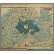
Projection of Mt. Fuji

A Chart of the SOUTH=SEA
Chart of northern part of Hiroshima Harbor (1928) (city appears on the chart). Report No. 3t(4), USSBS Index Section 2

A Correct Sea Chart of the Whole World, According to Wright's, Commonly Called Mercator's, Project...

A Correct Sea Chart of the Whole World, According to Wright's, Commonly Called Mercator's, Project...

A Generall Chart of the South Sea from the River of Plate to Dampiers Streights on ye Coast of New...
Personal message from General Montgomery on the occasion of the advance on Rome, World War II
Chart on Reparations Information
Declaration by the World Federation of Democratic Youth (WFDY/PODN) on the organisation of solida...
Declaration by the Executive Committee of the World Federation of Democratic Youth (WFDY/PODN) on ...

The World of Devas

India quae Orientalis dicitur et Insulae Adiacentes

A New Map of Great Tartary and China, with the adjoyning Parts of Asia, Taken from Mr. De Fer's Ma...

Mikoshinyuudou

A New Map of India & China From the latest Observations

Carte Des Indes et de la Chine Dressee sur plusieurs Relations particulieres Rectifees par quelque...

Nova Tabula India Orientalis Hugo Allardt Excudit inde Kalverstraet inde Werrelt Caerte

India quae Orientalis dicitur et Insulae Adiacentes

Asiae Recentissima Delineatio Qua Status et Imperia Totius Orientis unacum Orientalibus Indiis…

National school board series : No. 7 : Europa
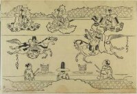
Korean Horseback Acrobats

Asiae Nova Descriptio

Asiae Recentissima Delineatio Qua Status et Imperia Totius Orientis unacum Orientalibus Indiis…

Accuratissima Totius Asiae Tabula Recens Emendata (heightened in gold)

Asia recens summa cura delineata Auct. Henr. Hondio 1631
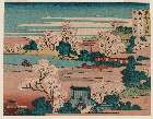
「勝景雪月花」 「摂津 桜の宮花」

Raifukujinohana
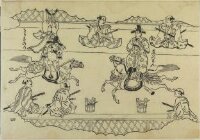
Korean Horseback Acrobats

The Empire of Japan Divided into Seven Principal Parts and Subdivided ino Sixty Six Kingdoms; with...

Iaponiae Insulae Descriptio Ludoico Teisera auctore

Australien (Sudland) auch Polynesien oder Inselwelt, insgemein der funfte Welltheil . . . 1802
Japan and adjacent regions of Asia and the Pacific Ocean / compiled and drawn in the Cartographic Section of the National Geographic Society
富士山(頂上俯瞰図)

Orandajin kari no zu (Object)
![Iaponiae Insulae Descriptio Ludoico Teisera auctore [Korea Shown As An Island]](https://stacks.stanford.edu/image/iiif/gc011ps6045%2F30909/full/!200,200/0/default.jpg)
Iaponiae Insulae Descriptio Ludoico Teisera auctore [Korea Shown As An Island]
Last Updated: 2020-04-16
Uploaded: 2021-07-27