
日本本州北西岸岩瀬及伏木錨地 = Iwase and Fushiki Anchorages at n. w. coast of Honshū-Japan
- Time
- Owner Organization

日本本州南岸志摩的矢港 = Japan, Honshū-south coast, Matoya Harbour
Yoshida-South Library, Kyoto University
IIIF Discovery in Japan

日本本州北西岸伯耆境港 = Japan, Honshū-north west coast, Sakai Harbour
Yoshida-South Library, Kyoto University
IIIF Discovery in Japan

日本本州北西岸若狭小濱港 = Japan Honshū, north west coast, Ohama Harbour
Yoshida-South Library, Kyoto University
IIIF Discovery in Japan

日本本州南岸東京海湾浦賀港 = Japan Honshū, south coast Tōkio gulf Uraga harbour
Yoshida-South Library, Kyoto University
IIIF Discovery in Japan

日本本州北西岸能登七尾湾= Japan Honshū, N. W. coast, Nanao Bay : north bay from survey of Lieutt. K. Kimotski, I. J. N. 12th. Year of Meiji (1879), South Bay, West Bay and the Soundings at outer part of the Bays from survey of commr. K. Isono
Yoshida-South Library, Kyoto University
IIIF Discovery in Japan

日本九州西岸肥前長崎港 = Japan Kiushū, west coast, Nagasaki Harbour
Yoshida-South Library, Kyoto University
IIIF Discovery in Japan

日本九州西岸肥後三角港 = Japan Kiūshū, west coast, Misumi Harbour
Yoshida-South Library, Kyoto University
IIIF Discovery in Japan

日本北州西岸後志小樽港 = Japan Hokusyū, west coast, Shiribeshi, Otaru Kō
Yoshida-South Library, Kyoto University
IIIF Discovery in Japan

日本四国南岸土佐浦戸港高知=Japan Shikoku, south coast, Urado Harbour and Kōchi
Yoshida-South Library, Kyoto University
IIIF Discovery in Japan

日本四国西岸伊豫宇和島湾 = Japan Shikoku, west coast Uwajima Bay surveyed by Lieut.ts S. Aoki, S.Yoshida, I. J. N. 8.th Year of Meiji, (1875), The Parts west of Ōra Zaki and Mizuga Ura enlarged from the survey of Comm.r K. Kimotski, I. J. N
Yoshida-South Library, Kyoto University
IIIF Discovery in Japan

The Ocean View Slope near Shirasuka, series Pictures of Famous Places on the Fifty Three Stations
Honolulu Museum of Art
Honolulu Museum of Art Collection

東松浦郡町村図(乙)横竹村
Saga Prefectual Library
IIIF Discovery in Japan

print; surimono
British Museum
British Museum Collection

surimono
British Museum
British Museum Collection

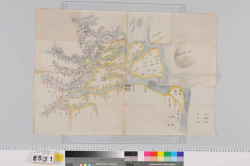
麻植郡森藤村絵図
Tokushima Prefectural Library
ADEAC: A System of Digitalization and Exhibition for Archive Collections

surimono
British Museum
British Museum Collection

梅渓閑居
Aichi Prefectural Museum of Art
The collection of Aichi Prefectural Museum of Art

日本国備図
Kyoto University Library
IIIF Discovery in Japan

花月双紙
Aichi Prefectural Museum of Art
The collection of Aichi Prefectural Museum of Art

Miniature Reproduction
Honolulu Museum of Art
Honolulu Museum of Art Collection

東松浦郡町村図(甲)瀬戸木場村
Saga Prefectual Library
IIIF Discovery in Japan

「関東地方アクセント分布図」金田一春彦
Hokkoro shi Kaneda Haruhiko Memorial Library
ADEAC: A System of Digitalization and Exhibition for Archive Collections

surimono
British Museum
British Museum Collection

surimono
British Museum
British Museum Collection
木曽川河口輪中絵図
Mie Prefectural Museum
三重県総合博物館所蔵品(人文)
Last Updated: 2020-04-16
Uploaded: 2021-07-27