

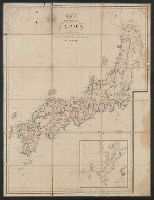
大日本國全圖
Kyoto University Library
IIIF Discovery in Japan

大日本國全圖
National Diet Library, Japan
ARC Early Japanese Book Portal Database

大日本國大繪圖
National Diet Library, Japan
ARC Early Japanese Book Portal Database

大日本全圖
Kyoto University Library
IIIF Discovery in Japan

大日本國沿海略圖
Kyoto University Library
IIIF Discovery in Japan

大和全國地圖
Nara Prefectural Library and Information Center
Mahoroba Digital Library

大日本海岸全圖
Kyoto University Library
IIIF Discovery in Japan

大日本海陸全圖
Kyoto University Library
IIIF Discovery in Japan

大日本帝國越中國土性圖
Yoshida-South Library, Kyoto University
IIIF Discovery in Japan

大日本帝國豊後全國豊前國東南部土性圖
Yoshida-South Library, Kyoto University
IIIF Discovery in Japan
萬國全圖
Shimane University Library Digital Archive Collection
IIIF Discovery in Japan

新撰縮圖大和全國地圖
Nara Prefectural Library and Information Center
Mahoroba Digital Library

大日本帝國中部地形圖
Yoshida-South Library, Kyoto University
IIIF Discovery in Japan

日本國中細見圖
National Diet Library, Japan
ARC Early Japanese Book Portal Database

武蔵國全圖
Tokyo Metropolitan Central Library
Tokyo Metropolitan Library Edo-Tokyo Digital Collections

改正大日本新精全圖
Kochi Prefectural Library
OTEPIA Kochi Library collection search

日本全圖 : 西部
Yoshida-South Library, Kyoto University
IIIF Discovery in Japan

日本全圖 : 東部
Yoshida-South Library, Kyoto University
IIIF Discovery in Japan

「大日本物産圖會」「同國長鮑製之圖」
Tokyo Metropolitan Central Library
Tokyo Metropolitan Library Edo-Tokyo Digital Collections

「大日本物産圖會」「伊勢國鮑採之圖」
Tokyo Metropolitan Central Library
Tokyo Metropolitan Library Edo-Tokyo Digital Collections

大日本帝國日向國土性圖 = Agronomic map of Hyūga-province
Yoshida-South Library, Kyoto University
IIIF Discovery in Japan

「徳島縣管内全圖」 大日本管轄分全圖
Kochi Prefectural Library
OTEPIA Kochi Library collection search

國郡全圖 2巻
Doshisha University
IIIF Discovery in Japan

重訂萬國全圖
Kyoto University Library
IIIF Discovery in Japan
Carte de L'Empire du Japon ..
Yale University Library
Yale University Library Digital Collections

print; hanging scroll
British Museum
British Museum Collection

探幽/梅ニ八頭図
Tokyo National Museum
Integrated Collections Database of the National Museums, Japan
![[3 maps of Leyte Island, Philippines, in Japanese.]](https://collections.library.yale.edu/iiif/2/15251299/full/!200,200/0/default.jpg)
[3 maps of Leyte Island, Philippines, in Japanese.]
Yale University Library
Yale University Library Digital Collections

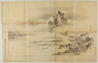
Earthquakes and Volcanoes
Yoshida-South Library, Kyoto University
IIIF Discovery in Japan

Jūmanbun no ichizu Furun Buiru
Stanford University Libraries
Stanford Libraries SearchWorks

painting; hanging scroll
British Museum
British Museum Collection
日本全圖 : 西部
Yoshida-South Library, Kyoto University
IIIF Discovery in Japan

巣鴨 庚申塚
National Diet Library
ADEAC: A System of Digitalization and Exhibition for Archive Collections

Karte von Australien oder Polynesien, nach den Zeichnungen, Reisebe Schreibungen und Tagebucher de...
Stanford University Libraries
Stanford Libraries SearchWorks
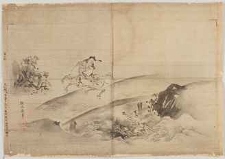
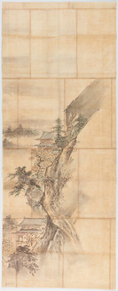
探幽/山水図
Tokyo National Museum
Integrated Collections Database of the National Museums, Japan

Chart of Discoveries made in 1787 In the Seas of China and Tartary between Manilla and Avateha by ...
Stanford University Libraries
Stanford Libraries SearchWorks
探幽/黄石公張良図
Tokyo National Museum
Integrated Collections Database of the National Museums, Japan
探幽/山水図
Tokyo National Museum
Integrated Collections Database of the National Museums, Japan
Last Updated: 2020-04-16
Uploaded: 2021-07-27