

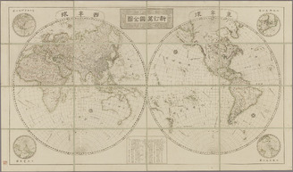
新訂萬國全圖
National Diet Library, Japan
ARC Early Japanese Book Portal Database
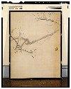
萬國全圖
Shimane University Library Digital Archive Collection
IIIF Discovery in Japan
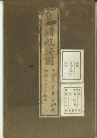
萬國航海圖
Shimane University Library Digital Archive Collection
IIIF Discovery in Japan
萬國航海圖
Shimane University Library Digital Archive Collection
IIIF Discovery in Japan

萬國一覽圖
National Diet Library, Japan
ARC Early Japanese Book Portal Database
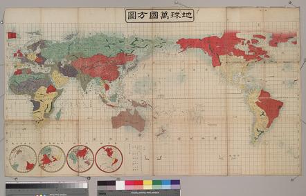
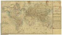
地球萬國方圖
国際日本文化研究センター
SODA Collection: Pictorial and Miscellaneous Materials

地球萬國山海輿地全圖説
Tokyo Metropolitan Central Library
Tokyo Metropolitan Library Edo-Tokyo Digital Collections

地球萬國山海輿地全圖説
Tokyo Metropolitan Central Library
Tokyo Metropolitan Library Edo-Tokyo Digital Collections
![[歴民カード_歴史] 重訂萬国全国](https://khirin-i.rekihaku.ac.jp/iiif/nmjh_rekimin_h/12447078_02.tif/full/200,/0/default.jpg)
[歴民カード_歴史] 重訂萬国全国
National Museum of Japanese History
IIIF Discovery in Japan

武蔵國全圖
Tokyo Metropolitan Central Library
Tokyo Metropolitan Library Edo-Tokyo Digital Collections

萬國一覽圖説 2巻
National Diet Library, Japan
ARC Early Japanese Book Portal Database

萬國一覽圖説 2巻
National Diet Library, Japan
ARC Early Japanese Book Portal Database

萬國一覽圖説 2巻
National Diet Library, Japan
ARC Early Japanese Book Portal Database

國郡全圖 2巻
Doshisha University
IIIF Discovery in Japan

大和全國地圖
Nara Prefectural Library and Information Center
Mahoroba Digital Library

大日本國全圖
Kyoto University Library
IIIF Discovery in Japan

大日本國全圖
Yoshida-South Library, Kyoto University
IIIF Discovery in Japan

大日本國全圖
National Diet Library, Japan
ARC Early Japanese Book Portal Database

重訂万国全図
National Diet Library, Japan
ARC Early Japanese Book Portal Database

朝鮮國全圖 : 附臺灣全島之圖
National Diet Library, Japan
ARC Early Japanese Book Portal Database

新撰縮圖大和全國地圖
Nara Prefectural Library and Information Center
Mahoroba Digital Library
増補繪圖萬寳全書
Kansai University Open Research Center for Asian Studies
IIIF Discovery in Japan
増補繪圖萬寳全書
Kansai University Open Research Center for Asian Studies
IIIF Discovery in Japan
増補繪圖萬寳全書
Kansai University Open Research Center for Asian Studies
IIIF Discovery in Japan
新訂万国全図
Kyushu National Museum
Integrated Collections Database of the National Museums, Japan

New Guinea - South Coast. Freshwater Bay to C. Blackwood
Stanford University Libraries
Stanford Libraries SearchWorks

(Southeast Asia, China &c.)
Stanford University Libraries
Stanford Libraries SearchWorks
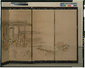
梅図・芦雁図襖
Tokyo National Museum
ARC Ukiyo-e Portal Database

Western Portions of Flores
Stanford University Libraries
Stanford Libraries SearchWorks

Karta Morskykh Otkrytii Rossiiskimi Moreplavatelimi na Tikhom ... [transliterated from the Cyrilli...
Stanford University Libraries
Stanford Libraries SearchWorks

(Southeast Asia, China &c.)
Stanford University Libraries
Stanford Libraries SearchWorks

Plans of Anchorages in Tomori Gulf and Adjacent Coast
Stanford University Libraries
Stanford Libraries SearchWorks

Ryukyu Islands roads, railroads and cables
Stanford University Libraries
Stanford Libraries SearchWorks

Jūmanbunnoichi Maroerapputō fukin
Stanford University Libraries
Stanford Libraries SearchWorks

Japan, Manchuria, and adjacent regions
Stanford University Libraries
Stanford Libraries SearchWorks

Carte Reduite Des Mers Comprises Entre L'Asie et L'Amerique Apelees par les Navigateurs Mer Du Sud...
Stanford University Libraries
Stanford Libraries SearchWorks
![[Russian Map of Northeastern Asia, Japan, Korea, China, Alaska, etc.] ( Summary map of hydrographi...](https://stacks.stanford.edu/image/iiif/pj697kr2558%2F35405/full/!200,200/0/default.jpg)
[Russian Map of Northeastern Asia, Japan, Korea, China, Alaska, etc.] ( Summary map of hydrographi...
Stanford University Libraries
Stanford Libraries SearchWorks
雨宿り図屏風
Tokyo National Museum
ARC Ukiyo-e Portal Database

Approach to West Coast of Gazelle Peninsula
Stanford University Libraries
Stanford Libraries SearchWorks

Chart of Discoveries made in 1787, in the Seas of China and Tartary, by the Boussole and Astrolabe...
Stanford University Libraries
Stanford Libraries SearchWorks

南瞻部洲之図
Kyoto University Library
IIIF Discovery in Japan

木の花の歌
Omiya Library, Saitama
ADEAC: A System of Digitalization and Exhibition for Archive Collections
Last Updated: 2020-04-16
Uploaded: 2021-07-27