
Carte réduite de l'Ocean Oriental depuis le Cap de Bonne Espérance jusqu'au Japon / dressée sur le...

Carte réduite de l'Ocean Oriental depuis le Cap de Bonne Espérance jusqu'au Japon / dressée sur le...

Carte réduite de l'Océan Oriental depuis le Cap de Bonne Espérance jusqu'au Japon / dressée sur le...

Carte réduite de l'Océan Oriental depuis le Cap de Bonne Esperance, jusqu'au Japon : dédiée à l'Ac...

Carte réduite de l'Océan Oriental depuis le Cap de Bonne Esperance, jusqu'au Japon : dédiée à l'Ac...

Carte réduite de l'Océan Oriental depuis le Cap de Bonne Esperance, jusqu'au Japon : dédiée à l'Ac...

Carte réduite de l'Océan oriental depuis le Cap de Espérance jusqu'au Japon / Par Mr. d'Après de M...
Voyages de C. P. Thunberg au Japon par le cap de Bonne-Espérance, les îles de la Sonde, etc

Voyages de C. P. Thunberg au Japon, par le Cap de Bonne-Espérance, les isles de la Sonde, &c. . Tr...

Voyages au Japon, par le cap de bonne-esperance, les isles de la Sonde etc. : Traduits ... et augm...

Voyages au Japon, par le cap de bonne-esperance, les isles de la Sonde etc. : Traduits ... et augm...

Carte generale d'une partie d'Afrique et d'Asie, depuis le Détroit de Gibraltar jusques aux Isles ...

Carte générale d'une partie d'Afrique et d'Asie depuis le détroit de Gibraltar jusqu'aux isles du ...

Japon. Carte / dressée pour les missions catholiques par M. R. Hausermann ; avec le concours de M....
Nieuwe wassende graet kaert van Oost Indien van d. C. d Bono Esperanca tot t'Lant Eso / gedruckt by I. Robyn met Privilege
Carte réduite de l'Océan oriental depuis le Cap de Espérance jusqu'au Japon / Par Mr. d'Après de M...

Carte réduite de l'océan septentrional compris entre l'Asie et l'Amérique ... Par le Sr. Bellin ..
Carte réduite de l'Océan Oriental depuis le Cap de Bonne Esperance, jusqu'au Japon : dédiée à l'Ac...

(Southeast Asia, China &c.)

A new & correct chart of the Indian sea from Cabo Bonea Esperanca to Japan : according to Mr Edwar...

Pas-caart van Zuyd-Zee, tusschen California en ilhas de Ladrones

Laurie and Whittle's New Chart of the Indian and Pacific Oceans Between the Cape of Good Hope, New...
Nisshi oyobi Nichi-Man kokusai renraku un'yu senrozu : Japan-China and Japan-Manchuria through traffic routes

(Southeast Asia, China &c.)
A chart of the eastermost part of the East Indies with all the adjacent islands from Cape Comorin to Iapan / by Iohn Seller, Hydrographer to the King

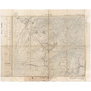
Map of Colorado Territory, Compiled from Government Maps & Actual Surveys. Made In 1861

Tabula Indiae Orientalis et Regnorum Adjacentium J. Van Braam et G. onder de Linden . .

Carte Reduite De L'Ocean Septentrional compris entre l'Asie et l'Amerique Suivant les Decouvertes ...

Iles Kouriles, Yeso et Sakhaline
山中湖(五万分一地形図甲府四号・応急修正版)
Oozuchidaikanshokannaizu

Carte Reduite De L'Ocean Septentrional compris entre l'Asie et l'Amerique Suivant les Decouvertes ...
Carte réduite de l'Océan Oriental depuis le Cap de Bonne Esperance, jusqu'au Japon : dédiée à l'Ac...

Carte Reduite Des Mers Comprises Entre L'Asie et L'Amerique Apelees par les Navigateurs Mer Du Sud...
![Ichimanbun no ichi chikeizu Shinkyō kinbō [cartographic material]](https://stacks.stanford.edu/image/iiif/jc790cg6868%2Fjc790cg6868_00_0001/full/!200,200/0/default.jpg)
Ichimanbun no ichi chikeizu Shinkyō kinbō [cartographic material]
Japanese Empire--802 M
![Hailaerh fukin zu [cartographic material]](https://stacks.stanford.edu/image/iiif/nc103dh1915%2Fnc103dh1915_00_0001/full/!200,200/0/default.jpg)
Hailaerh fukin zu [cartographic material]

Carte Reduite De L'Ocean Septentrional compris entre l'Asie et l'Amerique Suivant les Decouvertes ...
Last Updated:
Uploaded: 2021-07-27