
Carte réduite de l'Océan Oriental depuis le Cap de Bonne Esperance, jusqu'au Japon : dédiée à l'Ac...

Carte réduite de l'Océan Oriental depuis le Cap de Bonne Esperance, jusqu'au Japon : dédiée à l'Ac...

Carte réduite de l'Océan Oriental depuis le Cap de Bonne Esperance, jusqu'au Japon : dédiée à l'Ac...

Carte réduite de l'Océan Oriental depuis le Cap de Bonne Espérance jusqu'au Japon / dressée sur le...

Carte réduite de l'Ocean Oriental depuis le Cap de Bonne Espérance jusqu'au Japon / dressée sur le...

Carte réduite de l'Ocean Oriental depuis le Cap de Bonne Espérance jusqu'au Japon / dressée sur le...

Carte réduite de l'Océan oriental depuis le Cap de Espérance jusqu'au Japon / Par Mr. d'Après de M...

Voyages au Japon, par le cap de bonne-esperance, les isles de la Sonde etc. : Traduits ... et augm...

Voyages au Japon, par le cap de bonne-esperance, les isles de la Sonde etc. : Traduits ... et augm...
Carte réduite de l'Ocean Oriental depuis le Cap de Bonne Espérance jusqu'au Japon / dressée sur le...
Carte réduite de l'Océan Oriental depuis le Cap de Bonne Esperance, jusqu'au Japon : dédiée à l'Ac...
Stanford's map of eastern China, Japan and Korea : the seat of war in 1894
Korea / prepared ... by the Army Map Service, U.S. Army
A new & correct chart of the Indian Sea from Cabo Bonea Esperanca to Japan according to Mr. Edward Wrights projection vulgarly called Mercators chart
Tokyo and vicinity : showing bombed-out areas / prepared ... by Nippon Map Co

A Correct Sea Chart of the Whole World, According to Wright's, Commonly Called Mercator's, Project...

The Japanese empire : with central and southern Manchukuo (Manchuria)
Tokyo

Oonoshinmuranaikenchishitaezu
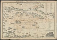
Kōgun senka kakudai ikkenzu : (fu) fukin chiten no koji gaisetsu
Piece

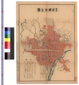
佐賀県管内図

A New and Correct Chart of all the Known World Laid down according to Mercator's Projection

Carte des terres aux environs du Japon ou du nord-est de l'Asie et du nord-ouest de l'Amérique ext...

Sanuki Zōzusan Seisai tōki dairyakuzu

An Improved Map of the United States By Shelton & Kensett

Carte générale de la Tartarie Chinoise dressée sur les cartes particulières faites sur les lieux p...
[Ajia tōbu meisaizu] / Okamura Shōbē cho

「大橋村 行事村 宮市村見取図」
Bird's eye view of Kioto and surrounding country / Y. Shimidzu

Carte du Japon sous la féodalité (Les divisions de Mutsu et Dewa datent de 1868). G. Appert / Grav...

A Chart of the Eastermost part of the East Indies and China from Cape Comarin to Japan with the Ad...
〈最新〉札幌市全図 : 最新札幌市全図
Last Updated:
Uploaded: 2021-07-27