Japanese trapped north of Garapan, on Saipan Island, in the Marianas, attempted to flee by means of boats in...
tf.S. Marines relax on a beach at Saipan Island, major Japanese supply jbase in thft Marianas Group cf the C...

Chart of the Discoveries to the North of Japan, in 1643, by the Dutch Ships the Kastrikum & the Br...

UPPER: Wrecked Japanese planes litter Tinian Island in the Marianas. In center background is a Super-Fortres...
Map showing Pelew Island, immediately north of Dutch New Guinea, and Dili, in Portuguese Timor, between whic...
Midway Island, a lonely United Stales outpost, 1300 miles north-west of Hawaii, attacked on Thursday by airc...
Members of a World War 2, North Island Battalion reconnaissance party, alongside a Bren carrier, in Libya
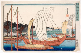
Entering Boats at Tsukuda Island (Tsukudajima Irifune no Zu), series Famous Views of the Eastern Capital (東都名所)
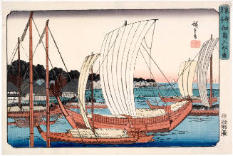
Entering Boats at Tsukuda Island (Tsukudajima Irifune no Zu), series Famous Views of the Eastern Capital (東都名所)

A Map of the Middle British Colonies In North America First Published By Mr. Lewis Evans of Philad...
Spahis of French North African Cavalry in Allied parade through Tunis in World War II - Photograph taken by ...

The great Chinese warship "Ting-Yuen," after being destroyed by the Japanese torpedo-boats, off the southern shore of Liukung Island
Ox carts common means of transport in area of Italian Front occupied by the NZ Division, World War II - Phot...
One of the heavy turret-type guns used by the Japanese to defend the island of Tarawa, recently captured by ...

Tsukada Island by Eitai Bridge in Edo from the series "36 Views of Mt Fuji"
Scale model of Nissan Island, Papua New Guinea, prepared by New Zealand Divisional Engineers in preparation ...
German mine causes building to sag, north of Pesaro, Italy, World War II - Photograph taken by George Kaye
The northern part of Luzon Island, in the Philippines, where a large Japanese force is reported to be attemp...

The Suicide of Two Foreign Clerks who Embezzled Funds from a French Bank in Yokohama, but were Overtaken by an English Ship as they Attempted to Escape, No. 647 from the series The Postal Newspaper (Yūbin hōchi shimbun)

Having Destroyed by Their Own Hands the Fortress of Makungcheng, the Enemy Soldiers Flee, Our Army's Great Victory (Tekihei mizukara Bakōjō o bakuhatsu shite tonsō su wagagun daishōri)
Keelung Harbor, Formosa Island : surveyed by order of Commodore M.C. Perry U.S.N. / by Lieut. G.H. Preble & Pd. Md. Walter F. Jones in the U.S. Ship Macedonian Capt. J. Abbot. ; drawn by Edwd. Sels ; engr. by Selmar Siebert
Page from Book of Okinawan Textiles: "Pub. no. 6 (refers to published version, in Rubel cage: AM1011.1.T-T); 1; Miyako Island, Ramie, Textile used by Royal Family"
To the north, the Japanese strongpoint of Pegu has fallen. In the west the Allies have entered the river por...

Reported to have been bombarded by Japanese warships: A street scene in Tsingtau, capital of the German poss...
A chart of the northern part of the China Sea shewing the passage from Formosa to Japan with the eastern coast of China and the Lekeyo islands / by Van Kuelen ; improved from the maps drawn in China by Father Gaubil in 1752
最終更新日:
登録日: 2020-12-17