
A mapp of the Formosa described by Candidius being Tyawan and part of the coast of Formosa
- Time
- Owner Organization
![[Taiwan and the Coast of Fujian and Guandong, China] Kaart van de Chineesche Kust en van Formosa v...](https://stacks.stanford.edu/image/iiif/zy510ks0323%2F34567/full/!200,200/0/default.jpg)
[Taiwan and the Coast of Fujian and Guandong, China] Kaart van de Chineesche Kust en van Formosa v...
Stanford University Libraries
Stanford Libraries SearchWorks

A Chart of the Coast of China From Cambodia to Nanquam with Part of Japan
Stanford University Libraries
Stanford Libraries SearchWorks

Japan : Nipon, Kiusiu and Sikok, and a part of the coast of Korea / according to Krusenstern's Chart of 1827 ; J & C Walker sculpt
Library of Congress
Trove: National Library of Australia

Japan described and illustrated by the Japanese section ten
Rijksmuseum
Rikijmuseum API

Chart of the Coast of China from Cambodia to Nanquam with Part of Japan
Stanford University Libraries
Stanford Libraries SearchWorks

The latest map of Manchuria, Korea, Formosa, and Saghalien
Stanford University Libraries
Stanford Libraries SearchWorks
A chart of ye eastermost part of the East Indies / by Iohn Seller
National Library of Australia
Trove: National Library of Australia

A portion of the shelter trenches on Motienling, on the E. coast of Wei-Hai-Wei
Rijksmuseum
Europeana API

A portion of the shelter trenches on Motienling, on the E. coast of Wei-Hai-Wei
Rijksmuseum
Rikijmuseum API
(Part of a Pipe)
Minneapolis Institute of Arts
Minneapolis Institute of Art API

Bronze Figurine, Being The Lid Of A Censer
NMNH - Anthropology Dept.
DPLA API
Map of Nanking, the Chinese southern capital, which is being attached by a Japanese army and is expected to ...
National Library of New Zealand
DigitalNZ New Zealand API

Japan described and illustrated by the Japanese section one
Rijksmuseum
Rikijmuseum API

A portion of the Lungmeaoutsuy forts, on the E. coast of Wei-Hai-Wei, and the Japanese torpedo-boat No. 22, run aground
Rijksmuseum
Rikijmuseum API

Part of Japan or Nipon. (with) View of the coast of Japan when we first saw it (Engraved by) W. H(...
Stanford University Libraries
Stanford Libraries SearchWorks
A new plaine and exact map of Asia / described by N.I. Vischer and rendered into English with habits of the countries and manner of the chiefe citties
National Library of Australia
Trove: National Library of Australia

Chart of the S.W. Part of Japan from a dutch MS / by A. Dalrymple ; W. Harrison sc
Bibliothèque nationale de France
Europeana API

Japan described and illustrated by the Japanese section four
Rijksmuseum
Europeana API

A general view of the Peishantsuy forts, on the W. coast of Wei-Hai-Wei
Rijksmuseum
Europeana API

A rear-view of the Peishantsuy forts, on the W. coast of Wei-Hai-Wei
Rijksmuseum
Europeana API

Strategical map of part of Korea and Manchuria / prepared by the Second Division, General Staff (Military In...
Yale University Library
Yale University Library Digital Collections

Morning glory and bamboo (part of a set, F1904.379-381)
Freer and Sackler
DPLA API

A map of the Empire of Japan, made by Dr. Kaempfer [with maps of Kamchatka, Northern coast of Japan, as well...
General Research Division. The New York Public Library
DPLA API
A List Birds of the Islands lying between Kiusiu and Formosa
Tomakomai City Central Library
ADEAC: A System of Digitalization and Exhibition for Archive Collections

Shinchiku shigaizu = : Map of Hsinchu city
Stanford University Libraries
Stanford Libraries SearchWorks

Descripcion De Las Indias Del Poniente
Stanford University Libraries
Stanford Libraries SearchWorks

滿洲歴史地理. : 第壹巻附図 : 後魏時代満洲図 (439-550)
Yoshida-South Library, Kyoto University
IIIF Discovery in Japan
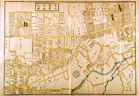
改正青山長者丸辺図 全
Geospatial Information Authority of Japan
FishPix
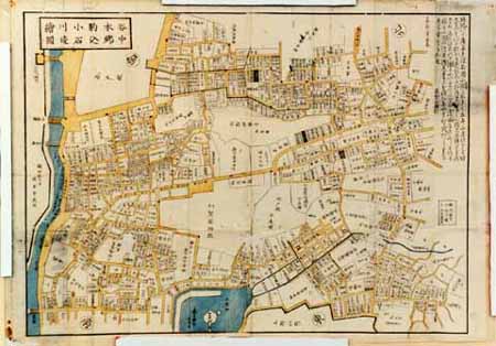
谷中本郷駒込小石川辺絵図
Geospatial Information Authority of Japan
FishPix

Kawagoe, Japan, Saitama-ken, Honshu
Stanford University Libraries
Stanford Libraries SearchWorks

Suite De L'Ocean Oriental Contenant Les Isles De La Sonde Les Costes De Tunquin Et De La Chine Les...
Stanford University Libraries
Stanford Libraries SearchWorks
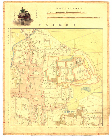
川越城及市街(五千分之一尺)
Geospatial Information Authority of Japan
FishPix
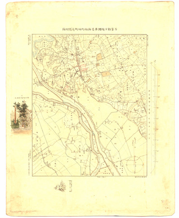
千葉縣下總國東葛飾郡野田町近傍村落
Geospatial Information Authority of Japan
FishPix
![[弘化改正大坂細見図]](https://lapis.nichibun.ac.jp/image?did=6&pic=2&fid=10-68_01_01.jpg)
[弘化改正大坂細見図]
国際日本文化研究センター
SODA Collection: Pictorial and Miscellaneous Materials

Carte particulière des isles du Japon et partie des costes de la Chine
Bibliothèque nationale de France
Europeana API

An Improved Map of the United States By Shelton & Kensett
Stanford University Libraries
Stanford Libraries SearchWorks

都市計畫基本圖. : 6 上賀茂
Yoshida-South Library, Kyoto University
IIIF Discovery in Japan
Last Updated: 2021-01-30
Uploaded: 2021-07-29