
Chart of the S.W. Part of Japan from a dutch MS / by A. Dalrymple ; W. Harrison sc

A Chart of the Coast of China From Cambodia to Nanquam with Part of Japan
Stanford University Libraries
Stanford Libraries SearchWorks

Chart of the Coast of China from Cambodia to Nanquam with Part of Japan
Stanford University Libraries
Stanford Libraries SearchWorks
A chart of ye eastermost part of the East Indies / by Iohn Seller
National Library of Australia
Trove: National Library of Australia
A Chart of the Northern Part of the China Sea [Material cartográfico] : shewing the Passage from F...
Biblioteca Nacional de España
Europeana API

A Chart of the Eastermost part of the East Indies and China from Cape Comarin to Japan with the Ad...
Stanford University Libraries
Stanford Libraries SearchWorks

Japan : Nipon, Kiusiu and Sikok, and a part of the coast of Korea / according to Krusenstern's Chart of 1827 ; J & C Walker sculpt
Library of Congress
Trove: National Library of Australia
A chart of the eastermost part of the East Indies with all the adjacent islands from Cape Comorin to Iapan / by Iohn Seller, Hydrographer to the King
National Library of Australia
Trove: National Library of Australia
The entrance of Nangasacqui the chief port of the island of Kiusiu in the Kingdom of Japan from the manuscript chart of the Dutch East India Company
National Library of Australia
Trove: National Library of Australia

Part of Japan or Nipon. (with) View of the coast of Japan when we first saw it (Engraved by) W. H(...
Stanford University Libraries
Stanford Libraries SearchWorks
A chart of the eastermost part of the East Indies with all the adjacent islands from Cape Comorin to Iapan / by Iohn Seller, Hydrographer to the King ; F. Lamb Sculp
State Library of New South Wales
Trove: National Library of Australia

A chart of the easternmost part of the East Indies with all the adjacent islands from Cape Comorin...
Royal Museums Greenwich
Europeana API
A chart of the South Sea / by J. Seller, J. Colson, W. Fisher, J. Atkinson & J. Thornton ; Dundee, sculp
National Library of Australia
Trove: National Library of Australia

News from the Dutch East Indies: landing of the Dutch troops on Bali
Netherlands Institute for Sound and Vision
Europeana API

News from the Dutch East Indies: landing of the Dutch troops on Bali
Netherlands Institute for Sound and Vision
Europeana API

Japan From The Solomons. (drawn by) Richard Edes Harrison 1943. Copyright 1943 Time Inc. (to accom...
Stanford University Libraries
Stanford Libraries SearchWorks
Example of accent from Japan, by female born 1988
British Library
Europeana API

Plan of the Harbour of Nangasaky : from an ancient MS. communicated in 1762 by capt. Alexander Hum...
Bibliothèque nationale de France
Europeana API

Japan From China. (drawn by) Richard Edes Harrison 1943. Copyright 1943. Time Inc. (to accompany) ...
Stanford University Libraries
Stanford Libraries SearchWorks

A new & correct chart of the Indian sea from Cabo Bonea Esperanca to Japan : according to Mr Edwar...
Bibliothèque nationale de France
Europeana API

A chart of the tradeing part of the East Indies and China, with the adjacent islands, from Surrat ...
Royal Museums Greenwich
Europeana API

A wedding scene in Japan, from a drawing by a native Japanese artist
Art and Picture Collection. The New York Public Library
DPLA API

A wedding scene in Japan, from a drawing by a native Japanese artist
Art and Picture Collection. The New York Public Library
DPLA API

REPRESENTATION OF THE EMPRESS OF JAPAN BY A MALE ACTOR
Auckland Libraries
DigitalNZ New Zealand API

Japan From Siberia. (drawn by) Richard Edes Harrison 1943. (to accompany) Look At The World: The F...
Stanford University Libraries
Stanford Libraries SearchWorks

「軍艦之図」
C. V. Starr East Asian Library, University of California, Berkeley
ARC Ukiyo-e Portal Database

The Kanda Myojin Shrine
Victoria and Albert Museum
Victoria and Albert Museums API
Plan of the Harbour of Nangasaky : from an ancient MS. communicated in 1762 by capt. Alexander Hum...
Bibliothèque nationale de France
Europeana API

(帆船)
C. V. Starr East Asian Library, University of California, Berkeley
ARC Ukiyo-e Portal Database
A Chart of the Coast of China From Cambodia to Nanquam with Part of Japan
Stanford University Libraries
Stanford Libraries SearchWorks

Noordoost Cust van Asia : van Iapan tot Nova Zemla
Stanford University Libraries
Stanford Libraries SearchWorks

Japon. Carte / dressée pour les missions catholiques par M. R. Hausermann ; avec le concours de M....
Bibliothèque nationale de France
Europeana API

「象頭山金比羅八景之内 満濃池遊鶴」
C. V. Starr East Asian Library, University of California, Berkeley
ARC Ukiyo-e Portal Database

Skizze des weges von Tokio nach Yumotto (Nikko Berge) nach eigenen Aufzeichnungen / von E. Knippin...
Bibliothèque nationale de France
Europeana API
A Garden of Celebrated Japanese and Chinese Paintings : [volume 2]
Metropolitan Museum of Art
The Metropolitan Museum of Art Digital Collection
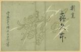
割烹 喜久本
Samukawa Archives
ADEAC: A System of Digitalization and Exhibition for Archive Collections
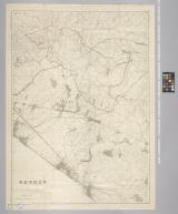
習志野演習場
Funabashi-shi Western Library
ADEAC: A System of Digitalization and Exhibition for Archive Collections

画本狂歌 山満多山 絵本
Keio University Media Center
Digital Collections of Keio University Libraries
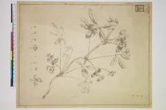
Akebi
Nationaal Museum van Wereldculturen (Rijksmuseum Volkenkunde, Leiden)
ARC Ukiyo-e Portal Database
Last Updated:
Uploaded: 2021-07-27