A Chart of the eastern ocean from C. Good-Hope to the Islands of Japan / drawn from the journals and remarks of the most skilful navigators more especially from those of M. d'Apres de Mannevillette
- Time
- Owner Organization

A Chart of the eastern ocean from C. Good Hope to the Islands of Japan / drawn from the journals and remarks - M. d'Après de Mannevillette
A Chart of the Eastern Ocean from C. Good Hope to the Islands of Japan [Material cartográfico]
A new & accurate map of Asia : drawn from the most approved modern maps & charts / by Thos. Bowen ; engraved for Middletons complete system of geography

Launch of EU/Japan Free Trade Agreement negotiations: extracts from the opening remarks
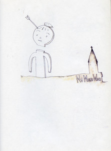
Untitled ("No More War" Gumby decapitated) from the series Time of My Life
Port Moresby : sketch map of the barracks and vicinity drawn from aerial photographs
Laurie and Whittle's new chart of the Indian and Pacific Oceans between the Cape of Good Hope, New Holland and Japan : comprehending New Zealand, New Caledonia, New Britain, New Ireland, New Guinea &c., Louisiade and New Georgia; also The Pelew, New Caroline, Ladrone and Philippine Islands &c. with the most remarkable tracks of the English, Spanish, French and Dutch navigators and chiefly the track of the Walpole, EastIndiaman, Captn. Thos. Butler, 1794 from the Cape of Good Hope to Van Diemen's Land and from thence to China, and the track of the Royal Admiral Captn. Henr. Bond in 1792 and 93 from the Cape to Port Jackson and China
Laurie and Whittle's new chart of the Indian and Pacific Oceans between the Cape of Good Hope, New Holland, and Japan, comprehending New Zealand, New Caledonia, New Britain, New Ireland, New Guinea,&c., Louisiade and New Georgia; also the Pelew, New Caroline, Ladrone, and Philippine Islands; &c. with the most remarkable tracks of the English, Spanish, French and Dutch navigators: and chiefly the track of the Walpole, Eastindiaman, Captn. Thos. Butler, 1794 from the Cape of Good Hope to Van Diemen's Land and, from thence to China, and the track of the Royal Admiral Captn. Henr. Bond in 1792 and 93, from the Cape to Port Jackson and China

A New Map of Asia from the latest Observations Most Humbly Inscrib'd to the Right Honbl. George Ea...

A New Map of Asia from the latest Observations Most Humbly Inscrib'd to the Right Honbl. George Ea...
Theater of war in the Pacific Ocean / compiled and drawn in the Cartographic Section of the National Geographic Society for the National Geographic Magazine
The country trade East-India pilot, for the navigation of the East-Indies and oriental seas, within the limits of the East-India Company, extending from the Cape of Good Hope to China, New Holland and New Zeeland, with the Red Sea, Gulf of Persia, Bay of Bengal, and China Seas / chiefly composed from actual surveys and draughts communicated by experienced officers of the East-India Company, and from the Neptune oriental by M. d'Apres de Mannevillette

Picture of a Ferocious Tiger Drawn from Life (Shasei moko no zu)

A New Chart of The Pacific Ocean, Exhibiting The Western Coast of America from Cape Horn to Beerin...
Has the tide of war turned for China? For two months or more the Japanese have been retreating from strategi...
A chart of the northern part of the China Sea shewing the passage from Formosa to Japan with the eastern coast of China and the Lekeyo islands / by Van Kuelen ; improved from the maps drawn in China by Father Gaubil in 1752

A New Chart of The Pacific Ocean, Exhibiting The Western Coast of America, From Cape Horn To Beeri...

A New Chart of The Pacific Ocean, Exhibiting The Western Coast of America, From Cape Horn To Beeri...
A New Chart of The Pacific Ocean, Exhibiting The Western Coast of America, From Cape Horn To Beeri...

A New and Accurate Map of the World. Drawn from the best Surveys and regulated by Astronomical Obs...

A voyage of discovery to the North Pacific Ocean in which the coast of Asia, from the lat. of 35@ ...
A voyage of discovery to the North Pacific Ocean in which the coast of Asia, from the lat. of 35@ ...

(Composite of) A New Chart of The Pacific Ocean, Exhibiting The Western Coast of America, From Cap...

Courtesans Drawn in Osaka Style (Osaka kakiwake), from "Courtesans of the Three Capitals - A Set of Three (Sanga no tsu keisei sanpukutsui)"
Last Updated: 2020-06-05
Uploaded: 2021-07-22