
Chart of the S.W. Part of Japan from a dutch MS / by A. Dalrymple ; W. Harrison sc

Chart of the S.W. Part of Japan from a dutch MS / by A. Dalrymple ; W. Harrison sc
A chart of ye eastermost part of the East Indies / by Iohn Seller

A Chart of the Coast of China From Cambodia to Nanquam with Part of Japan

Chart of the Coast of China from Cambodia to Nanquam with Part of Japan
A chart of the eastermost part of the East Indies with all the adjacent islands from Cape Comorin to Iapan / by Iohn Seller, Hydrographer to the King

Chart of the Discoveries to the North of Japan, in 1643, by the Dutch Ships the Kastrikum & the Br...
A Chart of the Northern Part of the China Sea [Material cartográfico] : shewing the Passage from F...
A chart of the South Sea / by J. Seller, J. Colson, W. Fisher, J. Atkinson & J. Thornton ; Dundee, sculp

Japan : Nipon, Kiusiu and Sikok, and a part of the coast of Korea / according to Krusenstern's Chart of 1827 ; J & C Walker sculpt
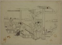
A Dutch Couple (Orandajin), published by Sanjōya Jimbei
A chart of the eastermost part of the East Indies with all the adjacent islands from Cape Comorin to Iapan / by Iohn Seller, Hydrographer to the King ; F. Lamb Sculp

A chart of the easternmost part of the East Indies with all the adjacent islands from Cape Comorin...
DIPTYCH (OR PART OF A LARGER SET?)
A chart of the northern part of the China Sea shewing the passage from Formosa to Japan with the eastern coast of China and the Lekeyo islands / by Van Kuelen ; improved from the maps drawn in China by Father Gaubil in 1752

A Chart of the Eastermost part of the East Indies and China from Cape Comarin to Japan with the Ad...

A Chart of the Eastermost part of the East Indies and China from Cape Comarin to Japan with the Ad...
East gun site, Blumine Island, Marlborough; part one of a two part panorama
Restoration of a Castle by ōta Shunei
Portion of NZ transport south east of Mersa Matruh, Egypt - Photograph taken by W A Whitlock
Chart of the coast of China and of the Japan Islands including the Marianes and a part of the Philippines / compiled by order of Commodore M.C. Perry U.S.N. from the latest authorities with additions and corrections by the U.S. Japan Expedition by Lieuts. W.L. Maury and S. Bent U.S.N. ; drawn by Edw. Sels ; engr. by S. Siebert

Chart of the coast of China and of the Japan islands including the Marianes and part of the Philippines
A chart of the South Sea / by John Seller, Hydrographer to the Kings most Excellent Majestie ; Dundee, sculp

China and Japan by Keith Johnston, F.R.S.E. (with) Islands of Japan. Engraved & printed by W. & A....
The entrance of Nangasacqui the chief port of the island of Kiusiu in the Kingdom of Japan from the manuscript chart of the Dutch East India Company
Chart of the S.W. Part of Japan from a dutch MS / by A. Dalrymple ; W. Harrison sc

Plan of the Harbour of Nangasaky : from an ancient MS. communicated in 1762 by capt. Alexander Hum...

Carte d'une partie de l'Île Jesso levée pendant l'expédition de Laxman au Japon en 1793

Plan of the Harbour of Nangasaky : from an ancient MS. communicated in 1762 by capt. Alexander Hum...

「軍艦之図」
The Kanda Myojin Shrine
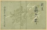
割烹 喜久本
![[Carte de l'Asie orientale] / [par Shihei Hayashi]](https://api.europeana.eu/api/v2/thumbnail-by-url.json?uri=http%3A%2F%2Fgallica.bnf.fr%2Fark%3A%2F12148%2Fbtv1b55000052n.thumbnail.jpg&type=IMAGE)
[Carte de l'Asie orientale] / [par Shihei Hayashi]
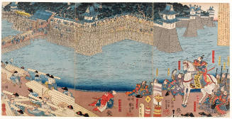
Dai ichi-gun no heitan : Meiji sanjūnana-nen hachi-gatsu nijūgo nichi
Dai ni-gun no heitan : Meiji sanjūnana-nen go-gatsu sanju-nichi
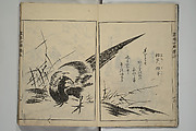
![[Wild boar sleeping beneath bushes during autumn]](https://tile.loc.gov/storage-services/service/pnp/jpd/02400/02431_150px.jpg)
[Wild boar sleeping beneath bushes during autumn]

Japon. Carte / dressée pour les missions catholiques par M. R. Hausermann ; avec le concours de M....

Carte des découvertes au Nord du Japon faites en 1643 par les vaisseaux hollandais le Kastrikum et...

「(正月の景)」

Plata Americae Provincia
画本必用

画本狂歌 山満多山 絵本
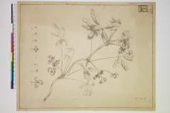
Akebi

Skizze des weges von Tokio nach Yumotto (Nikko Berge) nach eigenen Aufzeichnungen / von E. Knippin...
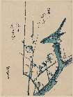
「梅(うめ)に鶯(うぐいす)」

〔神道修成派東口登山講 休伯(ママ)所定宿引札〕

Noordoost Cust van Asia : van Iapan tot Nova Zemla
〔江戸より小金原御鹿狩御立場迄略図〕

Nakagawamuraheizaemongumiimizugunhaokamuranaikenchiryouezu
Last Updated:
Uploaded: 2021-07-27