
Map of Manchuria, Corea & Japan
![[Manchuria] (7 sheet US Military Information Division Map of Manchuria)](https://stacks.stanford.edu/image/iiif/yr430hp5690%2F41524/full/!200,200/0/default.jpg)
[Manchuria] (7 sheet US Military Information Division Map of Manchuria)
Map - Manchuria, Military Situation (1931-1932)
![Map of Manchuria, Corea & Japan [cartographic material]](https://collections.library.yale.edu/iiif/2/15828540/full/!200,200/0/default.jpg)
Map of Manchuria, Corea & Japan [cartographic material]
Map - Manchuria, Military Situation 1932(6-13)

The latest map of Manchuria, Korea, Formosa, and Saghalien

Strategical Map of Part of Korea and Manchuria . . . 1906

Minamimanshuu kouzan bunpuzu = Map showing mineral distribution in South Manchuria
General map of northern China and Manchuria. Report No. 64a(12), USSBS Index Section 2

Korean War 1950-1953 -- Asia, North Korea, South Korea, China, Manchuria, Japan Map / Maps.com(CR)

General Railway Map of Japan and Manchuria : Showing lines open and under construction on March 31...
No. 93.1: Manchuria north, Manchuria areas; No. 93.2: Manchuria east, Manchuria areas; No. 93.3: Mukden, Manchuria areas.; No. 93.4: Manchuria west, Manchuria areas; No. 93.5: Dairen, Manchuria areas, 31 July 1944 Report No. 1-d(36), USSBS Index Section 7

Strategical map of part of Korea and Manchuria / prepared by the Second Division, General Staff (Military In...
Court Exh. No. 666: Outline of map of the Soviet Far East and northern part of Manchuria
Court Exh. No. 765A: Map pf Manchuria published on Page 10 Excerpt from Exhibit for identification No. 765
Court Exh. No. 765A: Map pf Manchuria published on Page 10 Excerpt from Exhibit for identification No. 765
Court Exh. No. 2714: Map of Khalkhin-Gol River District between Manchuria and Outer Mongolia. For idetification only
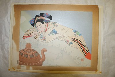
Sandalwood Smoke, Manchuria

Jehol (in Manchuria)
Map - Central Japan Road Map
Map - Northern Japan Road Map
Map - Northern Japan (Road Map)
Map - Southern Japan Road Map

map
Last Updated:
Uploaded: 2020-12-17