
Iapon or Niphon the land of Iesso and Straits of the Vries &c
- Owner Organization

map from "Niphon and Pe-che-li; or, Two years in Japan and Northern China. [With plates and a map....
A new chart of the Indian and Pacific Oceans between the Cape of Good Hope, New Holland and Japan : comprehending New Zealand, New Caledonia, New Britain, New Ireland, New Guinea &c., also the New Caroline, Ladrone and Philippine Islands : with the tracks of the English, French, Spanish and Dutch discoverers
A new mapp of y Empire of China : with its several provinces or kingdomes together w.th [i.e. with] the adjacent Isles of Iapon or Niphon, Formosa, Hainan, etc. / rendred into English & enlarged w.th the Isles of Iapon by Rich. [i.e. Richard] Blome by his Majesties command ; W. Hollar fecit 1669

Japanese play bill from "Niphon and Pe-che-li; or, Two years in Japan and Northern China. [With pl...

The Old And The New, Or Change Of Costume In Japan

A new chart of the Indian and Pacific Oceans between the Cape of Good Hope, New Holland and Japan : comprehending New Zealand, New Caledonia, New Britain, New Ireland, New Guinea &c., Louisade and New Georgia ; also the Pellew, New Caroline, Ladrone and Philippine Islands; with all these which have been discovered in the year 1788; & the tracks of the English, French, Spanish and Dutch discoverers
Laurie and Whittle's new chart of the Indian and Pacific Oceans between the Cape of Good Hope, New Holland, and Japan, comprehending New Zealand, New Caledonia, New Britain, New Ireland, New Guinea,&c., Louisiade and New Georgia; also the Pelew, New Caroline, Ladrone, and Philippine Islands; &c. with the most remarkable tracks of the English, Spanish, French and Dutch navigators: and chiefly the track of the Walpole, Eastindiaman, Captn. Thos. Butler, 1794 from the Cape of Good Hope to Van Diemen's Land and, from thence to China, and the track of the Royal Admiral Captn. Henr. Bond in 1792 and 93, from the Cape to Port Jackson and China
Laurie and Whittle's new chart of the Indian and Pacific Oceans between the Cape of Good Hope, New Holland and Japan : comprehending New Zealand, New Caledonia, New Britain, New Ireland, New Guinea &c., Louisiade and New Georgia; also The Pelew, New Caroline, Ladrone and Philippine Islands &c. with the most remarkable tracks of the English, Spanish, French and Dutch navigators and chiefly the track of the Walpole, EastIndiaman, Captn. Thos. Butler, 1794 from the Cape of Good Hope to Van Diemen's Land and from thence to China, and the track of the Royal Admiral Captn. Henr. Bond in 1792 and 93 from the Cape to Port Jackson and China

Fankwei; or, the San Jacinto in the seas of India, China and Japan
A New Chart of the Indian and Pacific Oceans Between the Cape of Good Hope, New Holland, and Japan...

JAPANESE THREAT TO AUSTRALIA: ENEMY FORCES LAND AT RABAUL, IN NEW GUINEA AND THE SOLOMON ISLANDS
Local people and New Zealand troops watch a heliocopter land, Malaya

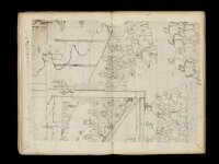
Map of the Island of Japan, Kurile &c. with the Adjacent Coasts of the Chinese Dominions and a Ske...

Map of the Island of Japan, Kurile &c. with the Adjacent Coasts of the Chinese Dominions and a Ske...

FRUITS OF TREACHERY After Pearl Harbour Malaya, the East Indies, New Guinea and New Britain fell like ninepi...
Foreign policy think tanks in China and Japan: characteristics, current profile, and the case of c...
Nippon [electronic resource] : the land and its people. The tradition of performing arts in Japan ...
New Guinea engineer : startling stories of peace and war in Queensland, Papua, New Guinea, New Britain, New Ireland and the Squally Islands / as told to Gillian Heming Shadbolt by wartime RAAF Flying Officer Les Bell

A Map of the Icy Sea in which the several Communications with the Land Waters and other new Discov...

A new and accurate map of the Empire of Japan : laid down from the memoirs of the Portuguese and Dutch, and ...

Haniwa Head and Vase (or) Clay Image

JAPAN MOVES SOUTHWARD IN THE FAR EAST: FRENCH TERRITORY OF INDO-CHINA OCCUPIED BY LAND AND AIR FORCES

WITH THE AUSTRALIANS IN TARAKAN AND NEW GUINEA: JAPANESE GARRISONS BEING REDUCED

A New and Accurate Map of the Empire of Japan Laid down from the Memoirs of the Portugese and Dutc...

India Orient

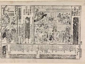
「江戸不忍ヶ池弁財天春之景」 「呼名 池ノ弁天」

Japan. Copyright 1892 by Appleton & Co. (insets) Kurile Islands; Tokyo. (to accompany) The Library...

〔冨士講社諸国商人定宿引札〕

Royaume du Iapon / désigné par le père Ph. Briet,... ; Somer sculp
Kuniyoshi's preparatory drawings, no.39

Japan. (inset) Plan of Yeddo Bay

Chuushinguraanasagashiyanagidaru

Colton's Japan, Nippon, Kiusiu, Sikok, Yesso (Hokkaido) and the Japanese Kuriles. (insets) Yesso a...
![Satsukinohanayoshiokazome、[ataridoshi]hatsutorasoga](http://mfas3.s3.amazonaws.com/styles/grid-2_thumbnail_retina/s3/objects/SC210401.jpg)
Satsukinohanayoshiokazome、[ataridoshi]hatsutorasoga

「東都芝万松山泉岳禅寺略図」 「附四十七士墓碑」
Kanjinkanmontekudanohajimari、yoshiwaraniwakanobanzuke、zenseimisaonohanaguruma

Carte du Japon

Colton's Japan, Nippon, Kiusiu, Sikok, Yesso and the Japanese Kuriles (inset) Yesso and the Japane...
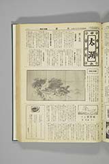
太湖 第45号

「洛北金閣寺」

Amerikatsūjin

「浪花八勝景」 「高津宮秋月」「桜野宮春景」「新町橋行人」「清水寺遠望」「高麗橋晴嵐」「天王寺晩鐘」「堂島川夕照」「弥陀池夜雨」

「大日本十二勝景」 「神都内外宮」「皇都御内裡」「江戸日本橋」「大坂高津宮」「野州日光山」「奥州松島」「安芸厳島」「甲州身延山」「丹後天橋立」「紀州高野山」「太宰府社」「讃州象頭山」

Plan de la ville et du port de Nangasaki d'après un ancien Plan Japonais réduit à moitié de l'Orig...
British and foreign possessions in the vicinity of Australia
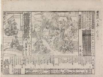
Koinoyamisatsukinouwanari、dannourakabutogunki

純喫茶 白鳥

The Attack and Defeat of the American Fleet under Benedict Arnold, by the Kings Fleet Commanded by...
Last Updated: 2021-01-30
Uploaded: 2021-07-29