
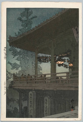
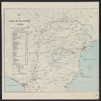
Nara, Yamada, Koyasan, & environs
- Time
- Owner Organization
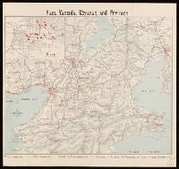
Nara, Yamada, Koyasan, & environs
Yale University Library
Yale University Library Digital Collections
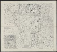
Ooi and Environs
Museum of Modern Art, New York
The Museum of Modern Art (MoMA) Collection

Map of Edo and Its Environs
Art Institute of Chicago
Art Institute of Chicago API

Mt. Fuji & its environs
Stanford University Libraries
Stanford Libraries SearchWorks
Great Gate of Koyasan
Harvard Art Museums
Harvard Art Museums API

Ichinomiya and environs, Aichi Prefecture, Honshu, Japan
Stanford University Libraries
Stanford Libraries SearchWorks
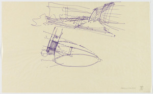
Nara Convention Hall, Nara, Japan, Perspective sketches for plaza and entrance lobby
Museum of Modern Art, New York
The Museum of Modern Art (MoMA) Collection
Ski and Yamada hotspring guide
National Gallery of Victoria
Trove: National Library of Australia

Mount Mikasa, Nara, from the series Shinto and its architecture
Freer and Sackler
DPLA API

Carte topographique de Kyoto et ses environs
Bibliothèque nationale de France
Europeana API
Klokkentoren op de berg Koyasan in de provincie Kii
Royal Library of the Netherlands
Europeana API
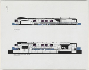
Nara Convention Hall Project, Nara, Japan, Competition drawing: east elevation and cross-sections of large and medium halls
Museum of Modern Art, New York
The Museum of Modern Art (MoMA) Collection

Statue of of Jizo at Jurin-in in Takahata, Nara, from the series "Ten Views of Nara"
Art Institute of Chicago
Art Institute of Chicago API

Bird's-eye-view Kyoto and its environs. (Cover title) Kyoto. Kyoto chokan zue
Stanford University Libraries
Stanford Libraries SearchWorks
Bird's-eye-view of Kyoto and its environs. (Cover title) Kyoto. Kyoto chokan zue.
Stanford University Libraries
Stanford Libraries SearchWorks
Evening in Nara (Later printing by Toshi Yoshida) (Nara no yū), series Kansai District
Honolulu Museum of Art
Honolulu Museum of Art Collection

Tama River of Koyasan, from Six Tama Rivers of Fahionable Dandies
Freer and Sackler
DPLA API

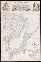
China and Japan. (with) Environs of Peking. (with) Environs of Tokio. (Published at the office of ...
Stanford University Libraries
Stanford Libraries SearchWorks

Burning mountain at an annual festival in Nara, Japan
Museum of New Zealand Te Papa Tongarewa
DigitalNZ New Zealand API

Burning mountain at an annual festival in Nara, Japan
Museum of New Zealand Te Papa Tongarewa
DigitalNZ New Zealand API

Entrance to the Kasuga Shrine at Nara and Group of Consecrated Maidens
General Research Division. The New York Public Library
DPLA API

Matsumoto Takegorō as Yamada Rokurō and Kawarasaki Gonjūrō II as Nishikuni Tarō
Honolulu Museum of Art
Honolulu Museum of Art Collection

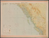
Yokohama and Vicinity
Stanford University Libraries
Stanford Libraries SearchWorks
Rubbing from Thirteenth-Century Relief of Jizō in Wakakusayama, Nara
Harvard Art Museums
Harvard Art Museums API
Nara, Yamada, Koyasan, & environs
Yale University Library
Yale University Library Digital Collections

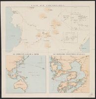
General map of China and adjacent regions showing treaty ports and railroads / prepared for the Department o...
Yale University Library
Yale University Library Digital Collections
Kyoto South : Kyoto Prefecture, Honshu, Japan
Yale University Library
Yale University Library Digital Collections
Islands of Japan
Yale University Library
Yale University Library Digital Collections
Unzen and neighbourhood
Yale University Library
Yale University Library Digital Collections

Ise Bay - North :
Yale University Library
Yale University Library Digital Collections
![[2 Maps of Korea:] Karte von der Koraischen Halbinsel... Nach einem japanischen Originale. 1840 [a...](https://stacks.stanford.edu/image/iiif/qt462tg9589%2F34409/full/!200,200/0/default.jpg)
[2 Maps of Korea:] Karte von der Koraischen Halbinsel... Nach einem japanischen Originale. 1840 [a...
Stanford University Libraries
Stanford Libraries SearchWorks

Nagasaki
Yale University Library
Yale University Library Digital Collections
Map and guide of Hakone and neighbourhood
Yale University Library
Yale University Library Digital Collections
Junō--Shiyatoru / Rikuchi Sokuryōbu, Sanbō Honbu
Yale University Library
Yale University Library Digital Collections

Jūmanbun no ichizu Kokuka oyobi Buragōweshichensuku
Stanford University Libraries
Stanford Libraries SearchWorks

大日本帝国油田地質及地形図 : 第5区 含油凝灰岩(しろ屑)ノ高距線図(北野・岩神・原油田)
Yoshida-South Library, Kyoto University
IIIF Discovery in Japan

Strategical map of part of Korea and Manchuria / prepared by the Second Division, General Staff (Military In...
Yale University Library
Yale University Library Digital Collections

map from "What will Japan do? A forecast, etc"
British Library
Europeana API

Japan and Korea / compiled and drawn in the Cartographic Section of the National Geographic Society ; James ...
Yale University Library
Yale University Library Digital Collections

亜細亜東部略図
Saga Prefectual Library
IIIF Discovery in Japan
![Kuwana kōkū shashin sokuryōzu [cartographic material]](https://stacks.stanford.edu/image/iiif/sp849hm7726%2Fsp849hm7726_00_0001/full/!200,200/0/default.jpg)
Kuwana kōkū shashin sokuryōzu [cartographic material]
Stanford University Libraries
Stanford Libraries SearchWorks
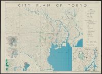
City plan of Tōkyō
Yale University Library
Yale University Library Digital Collections

山城国駅路図全
Kyoto University Library
IIIF Discovery in Japan

The New War Map of Maryland Part of Virginia & Pennsylvania. Published by B.B. Russell . .
Stanford University Libraries
Stanford Libraries SearchWorks
![Shisen fukin gojūmanbun no ichi chishizu [cartographic material] : heiyō chishizu](https://stacks.stanford.edu/image/iiif/nn836py9296%2Fnn836py9296_00_0001/full/!200,200/0/default.jpg)
Shisen fukin gojūmanbun no ichi chishizu [cartographic material] : heiyō chishizu
Stanford University Libraries
Stanford Libraries SearchWorks
Tokyo city bus routes : June, 1948 / compiled and reproduced by the 64th Engineer Base Topographic Bn
National Library of Australia
Trove: National Library of Australia

The Japanese empire : with central and southern Manchukuo (Manchuria)
Yale University Library
Yale University Library Digital Collections

Jūmanbun no ichizu Kita Karafuto oyobi Kokuryūkō karyū
Stanford University Libraries
Stanford Libraries SearchWorks
Last Updated: 2021-01-30
Uploaded: 2021-07-29