
Charts, etc
- Time
- Owner Organization

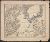
Asia, Japan and Korea : with the surrounding seas and the adjacent coastal region of China / published at Wa...
![Japan and adjacent regions of Asia and the Pacific Ocean [cartographic material] / compiled and drawn in the...](https://collections.library.yale.edu/iiif/2/15510875/full/!200,200/0/default.jpg)
Japan and adjacent regions of Asia and the Pacific Ocean [cartographic material] / compiled and drawn in the...
![Japan and adjacent regions of Asia and the Pacific Ocean [cartographic material] / compiled and drawn in the...](https://collections.library.yale.edu/iiif/2/15509964/full/!200,200/0/default.jpg)
Japan and adjacent regions of Asia and the Pacific Ocean [cartographic material] / compiled and drawn in the...

Japan and Korea. (with) The Japanese Empire. (with) Port Arthur and Adjacent Territory. (with) For...
Japan and adjacent regions of Asia and the Pacific Ocean / compiled and drawn in the Cartographic Section of the National Geographic Society
Stanford's map of the empires of China and Japan : with the adjacent parts of the Russian Empire, ...

Karta Aziatskoi Rossii . . . [Map of the Asian part of Russia and Possessions Adjacent, with the R...

A chart of the tradeing part of the East Indies and China, with the adjacent islands, from Surrat ...

Asia, China--South Korea--Japan, Yellow Sea, including the East China Sea and Korea Strait [electr...
Maps showing geology, oil and gas fields and geologic provinces of the Asia Pacific Region [electr...

China (East) and Korea. Scale 1: 7,500,000. Japan. Scale 1:5,000,000 (Published at the office of "...

Map of China And the Surrounding Regions. Compiled from the latest information by E. Bretscheider....

General map of China and adjacent regions showing treaty ports and railroads / prepared for the Department o...

Eastern Asia, showing Japan, Korea, Manchuria and adjoining parts of Siberia and China. 185 miles ...

Map of the Island of Japan, Kurile &c. with the Adjacent Coasts of the Chinese Dominions and a Ske...

Map of the Island of Japan, Kurile &c. with the Adjacent Coasts of the Chinese Dominions and a Ske...
Stanford's map of the empires of China and Japan with the adjacent parts of the Russian Empire, India, Burma &c / Stanford's Geogl. Estabt
General map of China and adjacent regions, showing treaty ports and railways / prepared for the Department of State, by the Topographic Branch, U.S. Geological Survey

China and Japan. (with) Environs of Peking. (with) Environs of Tokio. (Published at the office of ...
A map of the East-Indies and adjacent countries : with settlements, factories, and territories : explaining what belongs to England, Spain, France, Holland, Denmark, Portugal, etc. with many remarks not extant in any other map / by H. Moll, geog
A map of the East-Indies and adjacent countries : with settlements, factories, and territories : explaining what belongs to England, Spain, France, Holland, Denmark, Portugal, etc. with many remarks not extant in any other map / by H. Moll, geog
A new chart of the Pacific Ocean : exhibiting the western coast of America, from Cape Horn to Beerings Strait, the eastern shores of Asia including Japan, China and Australia and all the numerous islands and known dangers situated in Polynesia and Australasia / correctly drawn and regulated according to the most approved and modern surveys and astronomical observations by J.W. Norie
Tsunamis in the Pacific Basin, 1900-1983 / map produced by Patricia A. Lockridge, National Geophysical Data Center and Ronald H. Smith, Cooperative Institute for Research in Environmental Sciences ; published by National Geophysical Data Center and World Data Center A for Solid Earth Geophysics with support from Office of U.S. Foreign Disaster Assistance, Agency for International Development in cooperation with Circum-Pacific Council for Energy and Mineral Resources, Map Project
Asia, Japan and Korea : with the surrounding seas and the adjacent coastal region of China / published at Wa...
China (östlicheTheil), Korea und Japan im Massstab 1:7.500.000

Carte Physique & Politique. : No. 2 : l'Europe et du Bassin de la Méditerranée

(上陸)
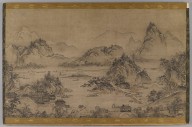
Landscape of West Lake
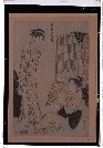
「風俗東之錦」

Hyakumanbun no ichi Nanpō kōkūzu

Carte Des Indes Orientales dessinee suivant les Observations les plus recentes dont le principal e...

Carte Physique & Politique. : No. 16 : l'Asie

1904 war map of Russia and the continent of Asia

Farmer and Elephant, Album Leaf Painting
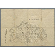
公余探勝図

「浅草御坊御遷仏略図」 「浅草御坊御遷仏略図」

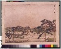
Snow at Dusk at Hira (Hira no bosetsu), from the series Eight Views of Omi in Etching Style (Doban Omi hakkei)
Map of the Island of Japan, Kurile &c. with the Adjacent Coasts of the Chinese Dominions and a Ske...
(Lower Sheet to) Map of the Island of Japan, Kurile &c. with the Adjacent Coasts of the Chinese Do...
Iaponia Regnvm
Pas-caert van't Oostelyckste deel van Oost Indien : met alle de Eylanden daer onder gelegen, van Cabo Comorin tot aen Japan / by Hendrick Doncker Boekverkooper en Graadbooghmaacker Inde Nieuwbrughsteegh

Iedo

(Composite Map of) Map of the Island of Japan, Kurile &c. with the Adjacent Coasts of the Chinese ...
富士山頂上図(表口、須山口)
Piece

ehonkaikasen
公余探勝図
Last Updated: 2021-01-30
Uploaded: 2021-07-29