
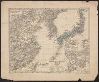
Asia, Japan and Korea : with the surrounding seas and the adjacent coastal region of China / published at Wa...
- Time
- Owner Organization

Charts, etc
Yale University Library
Yale University Library Digital Collections
![Japan and adjacent regions of Asia and the Pacific Ocean [cartographic material] / compiled and drawn in the...](https://collections.library.yale.edu/iiif/2/15510875/full/!200,200/0/default.jpg)
Japan and adjacent regions of Asia and the Pacific Ocean [cartographic material] / compiled and drawn in the...
Yale University Library
Yale University Library Digital Collections
![Japan and adjacent regions of Asia and the Pacific Ocean [cartographic material] / compiled and drawn in the...](https://collections.library.yale.edu/iiif/2/15509964/full/!200,200/0/default.jpg)
Japan and adjacent regions of Asia and the Pacific Ocean [cartographic material] / compiled and drawn in the...
Yale University Library
Yale University Library Digital Collections

Japan and Korea. (with) The Japanese Empire. (with) Port Arthur and Adjacent Territory. (with) For...
Stanford University Libraries
Stanford Libraries SearchWorks
Japan and adjacent regions of Asia and the Pacific Ocean / compiled and drawn in the Cartographic Section of the National Geographic Society
National Library of Australia
Trove: National Library of Australia
Stanford's map of the empires of China and Japan : with the adjacent parts of the Russian Empire, ...
VU University Amsterdam Library
Europeana API

Karta Aziatskoi Rossii . . . [Map of the Asian part of Russia and Possessions Adjacent, with the R...
Stanford University Libraries
Stanford Libraries SearchWorks

A chart of the tradeing part of the East Indies and China, with the adjacent islands, from Surrat ...
Royal Museums Greenwich
Europeana API

Asia, China--South Korea--Japan, Yellow Sea, including the East China Sea and Korea Strait [electr...
Stanford University Libraries
Stanford Libraries SearchWorks
Maps showing geology, oil and gas fields and geologic provinces of the Asia Pacific Region [electr...
Stanford University Libraries
Stanford Libraries SearchWorks

China (East) and Korea. Scale 1: 7,500,000. Japan. Scale 1:5,000,000 (Published at the office of "...
Stanford University Libraries
Stanford Libraries SearchWorks

Map of China And the Surrounding Regions. Compiled from the latest information by E. Bretscheider....
Stanford University Libraries
Stanford Libraries SearchWorks

General map of China and adjacent regions showing treaty ports and railroads / prepared for the Department o...
Yale University Library
Yale University Library Digital Collections

Eastern Asia, showing Japan, Korea, Manchuria and adjoining parts of Siberia and China. 185 miles ...
Bibliothèque nationale de France
Europeana API

Map of the Island of Japan, Kurile &c. with the Adjacent Coasts of the Chinese Dominions and a Ske...
Stanford University Libraries
Stanford Libraries SearchWorks

Map of the Island of Japan, Kurile &c. with the Adjacent Coasts of the Chinese Dominions and a Ske...
Stanford University Libraries
Stanford Libraries SearchWorks
Stanford's map of the empires of China and Japan with the adjacent parts of the Russian Empire, India, Burma &c / Stanford's Geogl. Estabt
National Library of Australia
Trove: National Library of Australia
General map of China and adjacent regions, showing treaty ports and railways / prepared for the Department of State, by the Topographic Branch, U.S. Geological Survey
National Library of Australia
Trove: National Library of Australia

China and Japan. (with) Environs of Peking. (with) Environs of Tokio. (Published at the office of ...
Stanford University Libraries
Stanford Libraries SearchWorks
A map of the East-Indies and adjacent countries : with settlements, factories, and territories : explaining what belongs to England, Spain, France, Holland, Denmark, Portugal, etc. with many remarks not extant in any other map / by H. Moll, geog
National Library of Australia
Trove: National Library of Australia
A map of the East-Indies and adjacent countries : with settlements, factories, and territories : explaining what belongs to England, Spain, France, Holland, Denmark, Portugal, etc. with many remarks not extant in any other map / by H. Moll, geog
State Library of New South Wales
Trove: National Library of Australia
A new chart of the Pacific Ocean : exhibiting the western coast of America, from Cape Horn to Beerings Strait, the eastern shores of Asia including Japan, China and Australia and all the numerous islands and known dangers situated in Polynesia and Australasia / correctly drawn and regulated according to the most approved and modern surveys and astronomical observations by J.W. Norie
State Library of New South Wales
Trove: National Library of Australia
Tsunamis in the Pacific Basin, 1900-1983 / map produced by Patricia A. Lockridge, National Geophysical Data Center and Ronald H. Smith, Cooperative Institute for Research in Environmental Sciences ; published by National Geophysical Data Center and World Data Center A for Solid Earth Geophysics with support from Office of U.S. Foreign Disaster Assistance, Agency for International Development in cooperation with Circum-Pacific Council for Energy and Mineral Resources, Map Project
National Library of Australia
Trove: National Library of Australia
Charts, etc
Yale University Library
Yale University Library Digital Collections
Iaponia Regnvm
VU University Amsterdam Library
Europeana API
China (östlicheTheil), Korea und Japan im Massstab 1:7.500.000
Yale University Library
Yale University Library Digital Collections

Carte Des Indes Orientales dessinee suivant les Observations les plus recentes dont le principal e...
Stanford University Libraries
Stanford Libraries SearchWorks

日本本州南岸自東京海湾至和泉海
Yoshida-South Library, Kyoto University
IIIF Discovery in Japan

Carte Des Indes et de la Chine Dressee sur plusieurs Relations particulieres Rectifees par quelque...
Stanford University Libraries
Stanford Libraries SearchWorks
Metropolitan Museum of Art
The Metropolitan Museum of Art Open Access CSV

Mikoshinyuudou
Nationaal Museum van Wereldculturen (Rijksmuseum Volkenkunde, Leiden)
ARC Ukiyo-e Portal Database

写生蝶之図
Tokyo National Museum
ARC Ukiyo-e Portal Database

(春の神のけそう)
C. V. Starr East Asian Library, University of California, Berkeley
ARC Ukiyo-e Portal Database

L'Empire de la Chine d'après l'Atlas Chinois, avec les Isles du Japon / Par M. Bonne, ..
Bibliothèque nationale de France
Europeana API

National school board series : No. 7 : Europa
Yoshida-South Library, Kyoto University
IIIF Discovery in Japan
Gojuusantsugimeishozue、fujisawa、nanchounomatsubarahidarifuji
Nationaal Museum van Wereldculturen (Rijksmuseum Volkenkunde, Leiden)
ARC Ukiyo-e Portal Database
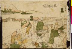
Nihonbashi
Nationaal Museum van Wereldculturen (Rijksmuseum Volkenkunde, Leiden)
ARC Ukiyo-e Portal Database

Hyakumanbun no ichi Nanpō kōkūzu
Stanford University Libraries
Stanford Libraries SearchWorks

Japanse motieven, onder andere konijnen, een vogel en rietstengels
Rijksmuseum
Europeana API

「象頭山金比羅八景之内 満濃池遊鶴」
C. V. Starr East Asian Library, University of California, Berkeley
ARC Ukiyo-e Portal Database

Song Wan, 'Giant in the Clouds'
Victoria and Albert Museum
Victoria and Albert Museums API
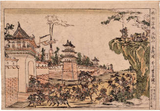
The Battle of Kyūsenzan, series Newly Published Perspective Pictures
Honolulu Museum of Art
Honolulu Museum of Art Collection

Japan, Mandshuria (Showing The Course of the Amur River) The Kurile Isles &c. Accroding to the Bri...
Stanford University Libraries
Stanford Libraries SearchWorks
![[海流]](https://rmda.kulib.kyoto-u.ac.jp/iiif/RB00024029/RB00024029_00001_0.ptif/full/200,/0/default.jpg)
[海流]
Yoshida-South Library, Kyoto University
IIIF Discovery in Japan

The Empire of Japan Divided into Seven Principal Parts and Subdivided ino Sixty Six Kingdoms; with...
Stanford University Libraries
Stanford Libraries SearchWorks
Träsnitt, Bildkonst, Woodblock, Woodcut, Print
Museum of Far Eastern Antiquities, Stockholm
Europeana API

Meishoedohyakkei、bikunibashi setchuu
Nationaal Museum van Wereldculturen (Rijksmuseum Volkenkunde, Leiden)
ARC Ukiyo-e Portal Database
Last Updated: 2021-01-30
Uploaded: 2021-07-29