
Japan / drawn under the direction of Mr. Pinkerton by L. Hebert ; Neele sculpt
- People
- Time
- Owner Organization

Japan. Drawn under the direction of Mr. Pinkerton by L. Hebert. Neele sculpt 352 Strand. London: p...
Stanford University Libraries
Stanford Libraries SearchWorks

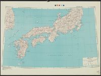
Japan road map, 1:1,000,000 / prepared under the direction of the Chief of Engineers, U.S. Army by the Army ...
Yale University Library
Yale University Library Digital Collections
Handbook to the colony of Victoria / prepared under the direction of the Victorian Government by Henry Heylyn Hayter
National Library of Australia
Trove: National Library of Australia
Series ; 5207
Yale University Library
Yale University Library Digital Collections

Corea and Japan. J. & G. Menzies sculpt., Edinr. Drawn & engraved for Thomson's New general atlas,...
Stanford University Libraries
Stanford Libraries SearchWorks
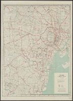
City map, central Tokyo / prepared under the direction of the Engineer, GHQ, FEC ; by the 64th Engineer Base Topographic Battalion
National Library of Australia
Trove: National Library of Australia
The story of Japanese farming in California. Prepared under the direction of Emil T. H. Bunje. Ber...
University of California Libraries
Europeana API
Chart of the world shewing the track of the U.S. steam frigates Mississippi, Susquehanna and Powhatan as flagships of the Japan Squadron under the command of Commodore M.C. Perry U.S.N. 1853-54 / drawn by Edw. Sels ; engr. by Selmar Siebert
National Library of Australia
Trove: National Library of Australia
City map, central Tokyo. December 1946 / prepared under direction of the chief engineer, general headquarter...
Yale University Library
Yale University Library Digital Collections

China and Japan. London: Published by Henry Teesdale & Co. Drawn & Engraved by J. Dower, Pentonvil...
Stanford University Libraries
Stanford Libraries SearchWorks
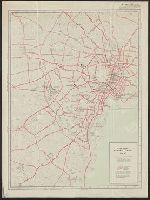
City map, central Tokyo. October 1947 / prepared under direction of the chief engineer, GHQ, FEC, byt the 64...
Yale University Library
Yale University Library Digital Collections

Japan. Drawn by A. Arrowsmith. Engraved by Sidy. Hall. Published, 1817, by A Constable & Co. Edinb...
Stanford University Libraries
Stanford Libraries SearchWorks

Japanese shrine representing the goddess of benevolence, presented to the Auckland Museum by Mr L D Nathan
Auckland Libraries
DigitalNZ New Zealand API
Basutos unloading ammunition under direction of New Zealanders on the Italian Front, World War II - Photogra...
Alexander Turnbull Library
DigitalNZ New Zealand API

Topographical map of the Japanese Empire, 1899 / Imperial Geological Survey of Japan ; drawn by T. Togawa an...
Yale University Library
Yale University Library Digital Collections
SCENES AND LIFE IN THE " LAND OF THE CHRYSANTHEMUM "—HAPPY JAPAN. (.Photos kindly lent by Mr A. Middleton.)...
National Library of New Zealand
DigitalNZ New Zealand API

China and Japan. Drawn & engraved by J. Dower. London, Published by Henry Teesdale & Co. (to accom...
Stanford University Libraries
Stanford Libraries SearchWorks
Reconnoissance of the Gulf and survey of the western shore of the Bay of Yedo / by order of Commodore M.C. Perry U.S.N. by Lieut. W.L. Maury and other officers of the U.S. Japan Expedition in 1853-54 ; drawn by Edw. Sels ; engr. by Selmar Siebert
National Library of Australia
Trove: National Library of Australia
The Prime Minister of Japan, Mr Nobusuke Kishi, with officials
Alexander Turnbull Library
DigitalNZ New Zealand API
The Prime Minister of Japan, Mr Nobusuke Kishi, with officials
Alexander Turnbull Library
DigitalNZ New Zealand API
The Prime Minister of Japan, Mr Nobusuke Kishi, with officials
Alexander Turnbull Library
DigitalNZ New Zealand API
Migrant arrivals and departures to New Zealand by citizens of Japan - By direction of travel, 2001–2019, num...
http://dbpedia.org/resource/Figshare
DigitalNZ New Zealand API
[The Hon Mr T L Macdonald addressing the crew of HMNZS Hawea, Korea]
Alexander Turnbull Library
DigitalNZ New Zealand API
Empire of Japan / published under the superintendence of the Society for the Diffusion of Useful Knowledge
National Library of Australia
Trove: National Library of Australia
![Japan [and Korea]](https://stacks.stanford.edu/image/iiif/xv761my3964%2F41979/full/!200,200/0/default.jpg)
Japan [and Korea]
Stanford University Libraries
Stanford Libraries SearchWorks
Het is goed om nieuwe kleding te dragen
Rijksmuseum
Rikijmuseum API

Greece in the fifth century B.C
Yoshida-South Library, Kyoto University
IIIF Discovery in Japan
Corea and Japan. J. & G. Menzies sculpt., Edinr. Drawn & engraved for Thomson's New general atlas,...
Stanford University Libraries
Stanford Libraries SearchWorks

Kawasaki
Library of Congress
Digital Collections, Library of Congress

Nova Et Accurata Iaponiae Terrae Esonis Ac Insularum . . . (Korea shown as an island)
Stanford University Libraries
Stanford Libraries SearchWorks

Map of Chosen (Korea)
Yale University Library
Yale University Library Digital Collections

Corea and Japan
Stanford University Libraries
Stanford Libraries SearchWorks

The Islands of Japan, by James Wyld,..
Bibliothèque nationale de France
Europeana API

Carte des terres aux environs du Japon ou du nord-est de l'Asie et du nord-ouest de l'Amérique ext...
Bibliothèque nationale de France
Europeana API

No. 12 from the series Korean Acrobats on Horseback
Philadelphia Museum of Art
Philadelphia Museum of Art collection
![上総国[東海道図]](https://rmda.kulib.kyoto-u.ac.jp/iiif/RB00020024/RB00020024_00001_0.ptif/full/200,/0/default.jpg)
上総国[東海道図]
Kyoto University Library
IIIF Discovery in Japan
Last Updated: 2021-01-30
Uploaded: 2021-07-29