
Japan, population changes 1935-1940
- Time
- Owner Organization

Kobe, density of population : 1940
Stanford University Libraries
Stanford Libraries SearchWorks

Population densities in Japan
Stanford University Libraries
Stanford Libraries SearchWorks
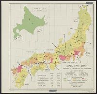
Japan: population densities by prefectures and province
Yale University Library
Yale University Library Digital Collections

Japan : population densities by prefectures and provinces
Stanford University Libraries
Stanford Libraries SearchWorks
![[Prins Chichibu, beschermheer Olympische Spelen in Japan 1940...]](https://api.europeana.eu/api/v2/thumbnail-by-url.json?uri=http%3A%2F%2Fwww.beeldbankwo2.nl%2Fcgi-bin%2Ffrsiserver.dll%2Fthumbnail%2F50680-thumb.jpg%3Ffrskey%3D50680&type=IMAGE)
[Prins Chichibu, beschermheer Olympische Spelen in Japan 1940...]
NIOD Institute for War, Holocaust and Genocide Studies
Europeana API

Japan, population, showing the relative amount of population from light, lowest, to dark, highest
The Miriam and Ira D. Wallach Division of Art, Prints and Photographs. The New York Public Library
DPLA API

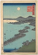
Central Japan (central and northern Honshū) distribution of population
Stanford University Libraries
Stanford Libraries SearchWorks

Life Full of Changes
Minneapolis Institute of Arts
Minneapolis Institute of Art API

The Japanese Empire: territorial changes
Stanford University Libraries
Stanford Libraries SearchWorks

Population densities in Japan : Densities by prefectures and provinces
Stanford University Libraries
Stanford Libraries SearchWorks
Social and Psychological Aspects of Ongoing Changes in Japan :Introduction
German National Library
Europeana API
Socio-Demographic Changes in Japan and Germany and Cross-Cultural Comparisons of the Value of Chil...
German National Library
Europeana API

Japán kávéház - Szilveszter 1935
Hungarian Museum of Trade and Tourism
Europeana API
The Japanese journal of population
Stanford University Libraries
Stanford Libraries SearchWorks
Geisha's : Lachende geisha in traditionele kleding. Japan, 1940
Royal Library of the Netherlands
Europeana API
Geisha's : Lachende geisha in traditionele kleding. Japan, 1940
Royal Library of the Netherlands
Europeana API
![[Japanese population increase.]](https://api.europeana.eu/api/v2/thumbnail-by-url.json?uri=http%3A%2F%2Fwww.beeldbankwo2.nl%2Fcgi-bin%2Ffrsiserver.dll%2Fthumbnail%2F49360-thumb.jpg%3Ffrskey%3D49360&type=IMAGE)
[Japanese population increase.]
NIOD Institute for War, Holocaust and Genocide Studies
Europeana API
Der Schein des Bündnisses - Deutschland und Japan im Krieg (1940 - 1945)
German National Library
Europeana API
Tropische culturen, rijstbouw Japan. Rijstoogst, dorp met bundels geoogste rijsthalmen. 1940
Royal Library of the Netherlands
Europeana API
Vrouwen onderzoeken gouden munten op gaafheid. Osaka, Japan, 1940
Royal Library of the Netherlands
Europeana API

New Zealand’s Japanese population, 1981–2001
New Zealand Ministry for Culture and Heritage
DigitalNZ New Zealand API

The Japan –US Military Alliance and the Asia-Pacific Challenges: Prospects for Deep Changes
Complutense University Library of Madrid
Europeana API
Geisha's : Groep Geisha's tijdens het bespelen van traditionele instrumenten. Japan, 1940
Royal Library of the Netherlands
Europeana API
Metro van Osaka met reizigers in Westerse en traditionele kleding. Japan 1940
Royal Library of the Netherlands
Europeana API

Japan, spring areas
Yale University Library
Yale University Library Digital Collections
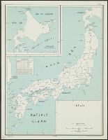
Japan
Yale University Library
Yale University Library Digital Collections

Japan, radiotelephone and radiotelegraph stations : 1941
Yale University Library
Yale University Library Digital Collections

Southwest Japan (Kyūshū, Shikoku, and southwest Honshū) administrative divisions
Stanford University Libraries
Stanford Libraries SearchWorks
![Japan, spring areas [cartographic material].](https://stacks.stanford.edu/image/iiif/gp763ck4840%2Fgp763ck4840_00_0001/full/!200,200/0/default.jpg)
Japan, spring areas [cartographic material].
Stanford University Libraries
Stanford Libraries SearchWorks

Kūchū shashin yōzu Gomanbunnoichi zu Bisumaruku guntō, Rabauru kinbō
Stanford University Libraries
Stanford Libraries SearchWorks
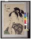
「青楼七小町」 「扇屋内瀧川」「男なみ」「女なみ」
Tokyo National Museum
ARC Ukiyo-e Portal Database

Provinces of Kansu and Ninghsia : Board of Economic Warfare / drawn in R. and A., O.S.S
Yale University Library
Yale University Library Digital Collections

Japan cities and towns : (shi and machi)
Yale University Library
Yale University Library Digital Collections
![Kantō area [cartographic material] : highways and waterways](https://stacks.stanford.edu/image/iiif/gd204cf5107%2Fgd204cf5107_00_0001/full/!200,200/0/default.jpg)
Kantō area [cartographic material] : highways and waterways
Stanford University Libraries
Stanford Libraries SearchWorks

「荒事 八代目団十郎 市川白猿」 「嘉永七寅年 浄延信士 八月六日 行年三十二才」
National Diet Library, Japan
ARC Ukiyo-e Portal Database

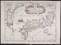
Carte des Isles du Japon et la Presqu Isle de Coree Avec les Costes de la Chine. Depuis Pekin Jusqu'a Canton...
Yale University Library
Yale University Library Digital Collections
Isola del Giapone e penisola de Corea / Vincenzo Coronelli
Yale University Library
Yale University Library Digital Collections

Central Japan (Central and Northern Honshū). Administrative divisions. No. 5282
Stanford University Libraries
Stanford Libraries SearchWorks
Metropolitan Museum of Art
The Metropolitan Museum of Art Open Access CSV
![[春英祭礼之図]](http://www.arc.ritsumei.ac.jp/archive01/theater/th_image/PB/kokkai/rarebook.ndl.go.jp/pre/th_image/gazou/W0000008/w0000120/w0000000/w0000003.jpg)
[春英祭礼之図]
National Diet Library, Japan
ARC Ukiyo-e Portal Database
![Government railroads of Japan [cartographic material].](https://stacks.stanford.edu/image/iiif/kn953gw3179%2Fkn953gw3179_0001/full/!200,200/0/default.jpg)
Government railroads of Japan [cartographic material].
Stanford University Libraries
Stanford Libraries SearchWorks

Nyūjōjiatō fukin sozu
Stanford University Libraries
Stanford Libraries SearchWorks

Isola del Giapone e penisola de Corea. Dedicata al Molto Revdo. Pre. Fontaine della compagnia de G...
Stanford University Libraries
Stanford Libraries SearchWorks
Koumyoubijinrokkasen
Tokyo National Museum
ARC Ukiyo-e Portal Database
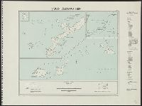
Okinawa-ken
Yale University Library
Yale University Library Digital Collections
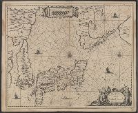
Nova et Accurata Japoniae, Terrae Esonis, ac Insularem Adjacentium ex Novissimâ detectione descriptio
Yale University Library
Yale University Library Digital Collections
Kaart van Oost-Azië / J. Wackie
VU University Amsterdam Library
Europeana API

Torokina Hikōjo
Stanford University Libraries
Stanford Libraries SearchWorks
Last Updated: 2021-01-30
Uploaded: 2021-07-29