
The Japanese empire : with central and southern Manchukuo (Manchuria)
- Time
- Owner Organization

The Japanese empire : with central and southern Manchukuo (Manchuria)

JAPANESE TROOPS OPERATING IN THE MOUNTAINS OF SOUTHERN MANCHURIA

Japan and Korea. (with) The Japanese Empire. (with) Port Arthur and Adjacent Territory. (with) For...

The Chinese Empire and Japan

The birds of the Japanese Empire
The birds of the Japanese Empire

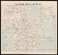
Opposing the Japanese in Manchuria

Tobacco production and consumption in the Japanese empire
Tobacco production and consumption in the Japanese empire

THE WAR IN MANCHURIA: SERIOUS FIGHTING BETWEEN CHINESE AND JAPANESE TROOPS

The Japanese Empire: territorial changes

Chinese Empire And Japan

Chinese Empire And Japan

Chinese Empire and Japan

Soldiers of the Russian empire passing through the gates of Mukden, Manchuria

SERIOUS GIGHTING BETWEEN CHINESE AND JAPANESE TROOPS IN MANCHURIA: THE JAPANESE OCCUPATION OF MUKDEN
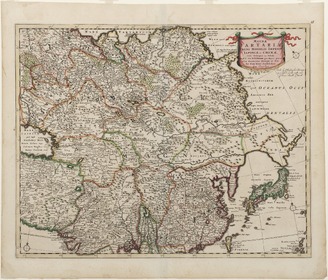
Stanford's map of the empires of China and Japan : with the adjacent parts of the Russian Empire, ...

Hokuryo, from the series Korea and Manchuria
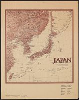
Japanese Empire--802 M
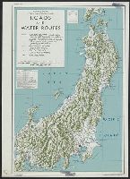
Central Japan :

Telecommunication and the Japanese Empire : a preliminary analysis of telegraphic traffic

Rand, McNally & Co.'s China. Chinese Empire with Japan and Korea

Terebridae of the Japanese empire / by Y. Hirase
Terebridae of the Japanese empire / by Y. Hirase
The Japanese empire : with central and southern Manchukuo (Manchuria)

佐賀県管内図

Nagasaki

Map of Chosen (Korea)

China, Contains 15 Subject Provinces, including the 2 Islands of Hainan Formosa and the Tributary ...
![Map of Manchuria, Corea & Japan [cartographic material]](https://collections.library.yale.edu/iiif/2/15828540/full/!200,200/0/default.jpg)
Map of Manchuria, Corea & Japan [cartographic material]

佐賀県管内図
![Japan and adjacent regions of Asia and the Pacific Ocean [cartographic material] / compiled and drawn in the...](https://collections.library.yale.edu/iiif/2/15510875/full/!200,200/0/default.jpg)
Japan and adjacent regions of Asia and the Pacific Ocean [cartographic material] / compiled and drawn in the...

Asia According to the best Authorities

日本交通分縣地圖 第二十九 佐賀縣
![Indo oyobi Seia [cartographic material] : Roppyakmanbun no ichi](https://stacks.stanford.edu/image/iiif/dx650yf2686%2Fdx650yf2686_00_0001/full/!200,200/0/default.jpg)
Indo oyobi Seia [cartographic material] : Roppyakmanbun no ichi

Tiefenkarte des Japanischen Binnenmeeres : Setouchi / von Dr. N. Yamasaki

Gojūmanbun no ichi Gobaikaru hōmen sozu
<i>Map of Tartary</i>
Nara, Yamada, Koyasan, & environs

Ise Bay - North :

Mandchourie Corée, Japon et côtes orientales de la chine d'après les documents russes, japonais et...
![[Carte du théâtre de la guerre en extrême orient] / [dressée par V. Adrianov]](https://api.europeana.eu/api/v2/thumbnail-by-url.json?uri=http%3A%2F%2Fgallica.bnf.fr%2Fark%3A%2F12148%2Fbtv1b53060752p.thumbnail.jpg&type=IMAGE)
[Carte du théâtre de la guerre en extrême orient] / [dressée par V. Adrianov]
Japan and adjacent regions / prepared and distributed by Army Information Branch, Army Service Forces

Japan and it's relation to the territory bordering on the Pacific ocean

Rand, McNally & Co.'s 1904 war map of Russia and the continent of Asia
China Divided into its Great Provinces and the Isles of Japan [Material cartográfico]
Korea / prepared ... by the Army Map Service, U.S. Army

1904 war map of Russia and the continent of Asia
Last Updated: 2021-01-30
Uploaded: 2021-07-29