
China divided into its great provinces and the Isles of Japan by Samuel Dunn
- Time
- Owner Organization

China, divided into its great provinces, and the Isles of Japan
China Divided into its Great Provinces and the Isles of Japan [Material cartográfico]

China divided into its Great Provinces, and The Isle of Japan . . . 1774

Asia According to the Sieur D'Anville Divided into its Empires, Kingdoms and States Showing the Eu...
The empire of Japan divided into seven principal parts and subdivided into six kingdoms with the k...

The Empire of Japan divided into seven principal parts and subdivided into sixty-six kingdoms; wit...
The Empire of Japan : divided into seven principal parts and subdivided into sixty six Kingdoms : ...
The Empire of Japan divided into seven principal parts and subdivided into sixty six kingdoms : wi...

The Empire of Japan Divided into Seven Principal Parts and Subdivided ino Sixty Six Kingdoms; with...

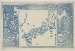
The Sixty-odd Provinces of Japan, a Catalogue of Famous Sites Shown at a Single Glance and Divided into a Game Board
Asia divided into its principall regions in which may be seen the extent of the empires, monarchies, kingdoms and states which at present divide Asia / described by Sanson ; corrected and amended by William Berry
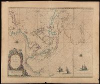
A new mapp of y Empire of China : with its several provinces or kingdomes together w.th [i.e. with] the adjacent Isles of Iapon or Niphon, Formosa, Hainan, etc. / rendred into English & enlarged w.th the Isles of Iapon by Rich. [i.e. Richard] Blome by his Majesties command ; W. Hollar fecit 1669

Asia distinguished into its principall parts
China and Japan / by Keith Johnston

ASIA Divided into its Principal STATES and REGIONS;with ALL THE ISLAND and THE NEW DISCOVERIES(アジア図)
Asia and its islands according to Danville : divided into empires, kingdoms, states, regions &ca. with the European possessions and settlements in the East Indies and an exact delineation of all the discoveries made in the Eastern parts by the English under Captn. Cook

Japan from "The Earth and its Inhabitants. The European section of the Universal Geography by E. R...
China and Japan / by W. and A. K. Johnston
3' outrages by the[Southerners on' Japanese residents In China,' at Tsinan and its vicinity, refultsd In the...
Calcutta to Liverpool by China, Japan and America in 1877, by H.W.N

The domestication of the cormorant in China and Japan / by Berthold Laufer, Curator, Department of...
The domestication of the cormorant in China and Japan / by Berthold Laufer, Curator, Department of...

China and Japan by Keith Johnston, F.R.S.E. (with) Islands of Japan. Engraved & printed by W. & A....
Japan, the islands of Loochoo & Formosa, and the maritime provinces of China with the tract of the Morrison's voyage in 1837 / J. Arrowsmith, Lith

L'Empire de la Chine avec les isles du Japon. A Paris, ches Lattre, rue St. Jacq. (ca. 1800)

Das Chinesische Reich mit den Schutz-Staaten, und Japan: entw. u. gez. v. C.G R.(eichard) 1826. Ge...

Hyakumanbun no ichi Nanpō kōkūzu

Album leaf
Paskaerte zynde t'Oosterdeel van Oost Indien : met alle de Eylanden daer ontrendt geleegen van C. Comorin to...

L'Empire de la Chine d'après l'Atlas Chinois avec les Isles du Japon . .

Iaponiae Insulae Descriptio. Ludoico Teisera auctore. Cum Imperatorio, Regio et Brabantiae | privi...

Indiae Orientalis, Insularumque Adiacentium Typus. Cum Privilegio

神埼二万分ノ一

Kuniyoshi's preparatory drawings, no.39

Partie du Japon. Asie no. 75. (Dresse par Ph. Vandermaelen, lithographie par H Ode. Deuxieme parti...

L'Empire de la Chine d'après l'Atlas Chinois, avec les Isles du Japon / Par M. Bonne, ..
Japanse schildering van huis in sneeuwlandschap

Tabula Tartariae et majoris partis regni Chinae / edita a F. de Wit ; Lhuilier fecit
「秋津洲」
Iaponia Regnum [Martino Martini]
Empire of Japan / published under the superintendence of the Society for the Diffusion of Useful Knowledge

Zee-atlassen, wereldkaarten enz. >> "A new and correct outline chart intended for the use of...
![[Japan] (Published in Manila!)](https://stacks.stanford.edu/image/iiif/gv355sq3352%2F37869hs/full/!200,200/0/default.jpg)
[Japan] (Published in Manila!)

Kuniyoshi's preparatory drawings, no.39
![Shina busshi ryūdo sōgō zu [cartographic material]](https://stacks.stanford.edu/image/iiif/sy422nt0000%2Fsy422nt0000_00_0001/full/!200,200/0/default.jpg)
Shina busshi ryūdo sōgō zu [cartographic material]

Empire of Japan. (with) Nagasaki Harbour. Engraved by J. & C. Walker. Published under the superint...

Kuniyoshi's preparatory drawings, no.48

Kuniyoshi's preparatory drawings, no.39
Last Updated: 2021-01-30
Uploaded: 2021-07-29