A new map of the empires, states, provinces &c of Asia : including also the Turkish & Russian dominions in Europe & New Holland / compiled from the most authentic observations by Robert Wilkinson ; Walsh script. ; W. Palmer sculpt
- Time
- Owner Organization

A New Map of Asia from the latest Observations Most Humbly Inscrib'd to the Right Honbl. George Ea...

A New Map of Asia from the latest Observations Most Humbly Inscrib'd to the Right Honbl. George Ea...
To the Right Honourable William, Lord Cowper, Lord High Chancellor of Great Britain, this map of Asia : according to ye newest and most exact observations is most humbly dedicated / by your Lordship's most humble servant, Herman Moll, geographer
Laurie and Whittle's new chart of the Indian and Pacific Oceans between the Cape of Good Hope, New Holland, and Japan, comprehending New Zealand, New Caledonia, New Britain, New Ireland, New Guinea,&c., Louisiade and New Georgia; also the Pelew, New Caroline, Ladrone, and Philippine Islands; &c. with the most remarkable tracks of the English, Spanish, French and Dutch navigators: and chiefly the track of the Walpole, Eastindiaman, Captn. Thos. Butler, 1794 from the Cape of Good Hope to Van Diemen's Land and, from thence to China, and the track of the Royal Admiral Captn. Henr. Bond in 1792 and 93, from the Cape to Port Jackson and China
Laurie and Whittle's new chart of the Indian and Pacific Oceans between the Cape of Good Hope, New Holland and Japan : comprehending New Zealand, New Caledonia, New Britain, New Ireland, New Guinea &c., Louisiade and New Georgia; also The Pelew, New Caroline, Ladrone and Philippine Islands &c. with the most remarkable tracks of the English, Spanish, French and Dutch navigators and chiefly the track of the Walpole, EastIndiaman, Captn. Thos. Butler, 1794 from the Cape of Good Hope to Van Diemen's Land and from thence to China, and the track of the Royal Admiral Captn. Henr. Bond in 1792 and 93 from the Cape to Port Jackson and China
A new & accurate map of Asia : drawn from the most approved modern maps & charts / by Thos. Bowen ; engraved for Middletons complete system of geography

A new chart of the Pacific Ocean : exhibiting the western coast of America, from Cape Horn to Beerings Strait, the eastern shores of Asia including Japan, China and Australia and all the numerous islands and known dangers situated in Polynesia and Australasia / correctly drawn and regulated according to the most approved and modern surveys and astronomical observations by J.W. Norie
Navigantium atque itinerantium bibliotheca ; Or, A complete collection of voyages and travels : Consisting of above six hundred of the most authentic writers ... Containing whatever has been observed worthy of notice in Europe, Asia, Africa, and America ... the climate, soil and produce ... of each country: likewise the religion, manners, and customs ... To which is prefixed a copious introduction, comprehending the rise and progress of the art of navigation ... together with the invention and use of the loadstone ... / by John Harris ... .
「江都名所 金竜山之図」
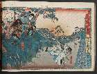
「伊賀越道中双六 十二」 「伊賀の上野に於て和田志津摩父の讐沢井俣五郎を討図」「和田志津摩」「沢井俣五郎」

(Composite Map of) Map of the Island of Japan, Kurile &c. with the Adjacent Coasts of the Chinese ...
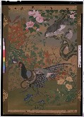
花鳥図

A Map of the East-Indies and the Adjacent Countries; with the Settlements, Factories and Territori...
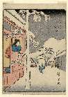
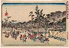
「(人物東海道)五十三次」 「水口(みなくち)」
L'empire de la Chine : d'après l'atlas Chinois, avec les isles du Japon / par M. Bonne, Membre de la Societʹe Litteraire Militre. Ingenieur Gʹeographe &c

東亜現勢地図

Atlas Russicus mappa una generali et undeviginti specialibus vastissimum imperium Russicum adjacen...

Tiefenkarte des Japanischen Binnenmeeres : Setouchi / von Dr. N. Yamasaki
A new map of India & China from the latest observations / by I. Senex
Imperii Sinarum nova descriptio [prepared by Martino Martini]
Japanse schildering met diverse eenden

China and Japan
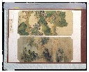
山水花鳥雑画帖_山水図

Ost-Indien

A Chart of the Eastermost part of the East Indies and China from Cape Comarin to Japan with the Ad...

Tatariae Sinensis Mappa Geographica ex Tabulis secialibus R.R.P.P. Iesuitarum nec non Relationibus...

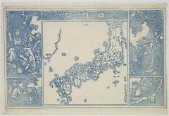
Nijūmanbun no ichi Chishizu
「秋津洲」

Australien (Sudland) auch Polynesien oder Inselwelt, insgemein der funfte Welltheil . . . 1802
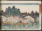
「東都名所」 「芝増上寺山内ノ図」

Northwestern America Showing The Territory Ceded By Russia To The United States Compiled For The D...

Asia According to the best Authorities
Last Updated: 2020-06-05
Uploaded: 2021-07-22