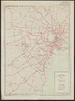
Tokyo and vicinity : showing bombed-out areas / prepared ... by Nippon Map Co
- People
- Time
- Owner Organization

Tokyo and vicinity, showing bombed-out areas. (Regional map on verso)
![Tokyo and vicinity, showing bombed-out areas [cartographic material]](https://stacks.stanford.edu/image/iiif/jx217xm7539%2Fjx217xm7539_00_0001/full/!200,200/0/default.jpg)
Tokyo and vicinity, showing bombed-out areas [cartographic material]
New railway map of Tokyo and vicinity. Published by Japan Guide Map Co., Ltd. Compiled and printed...
Map showing New Britain and the town of Rabaul, which has been bombed by Japanese aircraft. (Evening Post, 0...

General map of China and adjacent regions showing treaty ports and railroads / prepared for the Department o...

(Shikotsu, Toya and vicinity). (to accompany) Shomitsu Nippon chizu. (Atlas of Japan). Nippon Shoi...
General map of China and adjacent regions, showing treaty ports and railways / prepared for the Department of State, by the Topographic Branch, U.S. Geological Survey

Erie Railway and connections. (inset) Map of New York City & vicinity issued by N.Y.L.E. & W. R.R....
Blueprint map showing area destroyed or burned by atomic bomb and areas burned out or partially destroyed by other air raids, Map showing location and range of each air-raid warning siren. Report No. 5c, No. 5d, USSBS Index Section 2
City map, central Tokyo / prepared under the direction of the Engineer, GHQ, FEC ; by the 64th Engineer Base Topographic Battalion
City map, central Tokyo / prepared under the direction of Office of the Engineer, HQ, AFFE, by the 64th Engineer Battalion (Base Topographic)

Target Tokyo. Newsmap. Prepared and Distributed by the Army Orientation Course. Special Service Di...
Court Exh. No. 882: Copies of map prepared and issued by the American Army Map Service showing mandated islands of Japan and their situation with respect to other countries
Target Tokyo. Newsmap. Monday, October 18, 1943. ... Vol. II No. 26. Prepared and Distributed by t...
Map of Nagasaki City showing A-bomb damage (prepared by Lieutenant Colonel Oya, 1st Demobilization Ministry Tokyo). Report No. 3t(8), USSBS Index Section 2
City map, central Tokyo. October 1947 / prepared under direction of the chief engineer, GHQ, FEC, byt the 64...
Gouvt. Groote Oost. Res. Molukken (Nieuw-Guinea) Division Great East Residency Moluccas (New Guinea) / prepared and reproduced by Base Map Plant, USASOS, SWPA ... from Dutch map printed by Topografische Dienst (Topographic Service)
Map showing the area now occupied by Japanese troops when they advanced on Canton. (Evening Post, 22 October...

Map of China And the Surrounding Regions. Compiled from the latest information by E. Bretscheider....
East Asia and North Pacific 1:4,350,000 / prepared under the direction of the Chief of Engineers by the Army Map Service (AM) ; U.S. Army, Washington, D.C
Map showing area damaged by the atomic bomb at Nagasaki. (A numbered key to map shows important buildings as designated on the map.) (Original and seven copies.) (Prepared by Nagasaki Prefecture police department, Hoan-ka Public welfare section). Report No. 3t(14), USSBS Index Section 2
Yokohama city map : corrected to May 1954 / prepared under the direction of Office of the Engineer, AFFE, by the 29th Engineer Battalion (Base Topographic)
Map of Nagasaki atomic-bomb damage (extent and type of damage to various buildings is shown). (Prepared by Central Non-Life Insurance Corporation, Tokyo). Report No. 3t(12), USSBS Index Section 2
Map of Hiroshima atomic-bomb damage (ex-tent and type of damage to various buildings is shown). (Prepared by Central Non-Life In-surance Corporation, Tokyo). Report No. 3t(11), USSBS Index Section 2
Tokyo and vicinity, showing bombed-out areas [cartographic material]
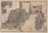
静岡県管内全図 : 静岡県管内全図
![[Carte du théâtre de la guerre en extrême orient] / [dressée par V. Adrianov]](https://api.europeana.eu/api/v2/thumbnail-by-url.json?uri=http%3A%2F%2Fgallica.bnf.fr%2Fark%3A%2F12148%2Fbtv1b53060752p.thumbnail.jpg&type=IMAGE)
[Carte du théâtre de la guerre en extrême orient] / [dressée par V. Adrianov]
.jpg)
「風流養老滝」
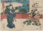
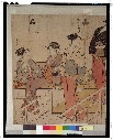
「笹の三五兵へ」 「市川海老蔵/源五兵衛」「中村芝翫」

Eastern Asia, showing Japan, Korea, Manchuria and adjoining parts of Siberia and China. 185 miles ...
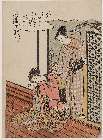
「略(やつし)近江八景」 「堅田(かただ)落雁(らくがん)」

Kaikoku zenzu
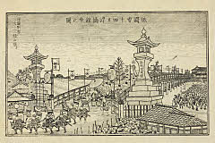
「祇園会十四日浮橋館幸之図」
Asia divided into its principall regions in which may be seen the extent of the empires, monarchies, kingdoms and states which at present divide Asia / described by Sanson ; corrected and amended by William Berry
「四条河原夕涼体」
Tokyo
「淀川堤之図」
Accuratissima totius Asiae tabula : in omnes partes divisa, de nova correcta, ac in lucem edita / per Fredericum de Witt Amstelodami cum privilegio D.D. ordinum Hollandiae Westristacqs ; F. de Wit excudit
L'empire de la Chine : d'après l'atlas Chinois, avec les isles du Japon / par M. Bonne, Membre de la Societʹe Litteraire Militre. Ingenieur Gʹeographe &c
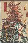
「不動 ふどう」「十八番の内 九」 「不動明王の霊像」「矜羯羅童子」「制多伽童子」

Boushuuzu

Kaikoku zenzu
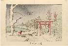
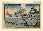
「箱根神社雪」

Yamanashiken kannai zenzu
公余探勝図

「扇屋内 花扇」 (見立普賢菩薩)

「(行書東海道)東海道五十三次之内」 「御油(ごゆ)」
A new map of India & China from the latest observations / by I. Senex
Last Updated: 2020-06-05
Uploaded: 2021-07-22