
The birds of the Japanese Empire
The birds of the Japanese Empire

The Japanese Empire: territorial changes
Dau Nihon Teikoku kōsanzu : Mineral distribution of Japanese empire

Terebridae of the Japanese empire / by Y. Hirase
Terebridae of the Japanese empire / by Y. Hirase

Map of the Great Japanese Empire (Dainihon Kokugun Yochi Zenzu)

Empire of Japan

Empire of Japan . .

The Japanese empire : with central and southern Manchukuo (Manchuria)

The Japanese empire : with central and southern Manchukuo (Manchuria)

Chinese Empire & Japan

Tobacco production and consumption in the Japanese empire
Tobacco production and consumption in the Japanese empire
Japanese Empire / produced under the direction of Alexander Gross, F.R.G.S

Chinese Empire And Japan

Chinese Empire And Japan

Chinese Empire and Japan

Chinese Empire
Landkarte des: Empire of Japan/Kaiserreich Japan

Russian Empire

The Chinese Empire and Japan

Geological map of the Japanese Empire on the scale of 1:1,000,000
Chinese Empire, and Japan
A new & accurate map of Asia : drawn from the most approved modern maps & charts / by Thos. Bowen ; engraved for Middletons complete system of geography

A New and Correct Chart of all the Known World Laid down according to Mercator's Projection

Mappemonde ou Carte Reduite Des Parties Connues Du Globe Pour servir au Voyage de La Perouse …. 17...
Zeekaart van het oostelijk deel van de Indische Oceaan, van India tot Australië en Japan
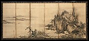
Screen

Karte von Australien oder Polynesien, nach den Zeichnungen, Reisebe Schreibungen und Tagebucher de...
IAPONIA REGNVM

Karte von Australien oder Polynesien, nach den Zeichnungen, Reisebe Schreibungen und Tagebucher de...
A chart of the eastermost part of the East Indies with all the adjacent islands from Cape Comorin to Iapan / by Iohn Seller, Hydrographer to the King

Karta Morskykh Otkrytii Rossiiskimi Moreplavatelimi na Tikhom ... [transliterated from the Cyrilli...

富士山名細図并東海名所案内

Carte De La Louisiane Colonie Francaise avec le Cours du Fleuve St Louis…1757

Carte réduite de l'Océan Oriental depuis le Cap de Bonne Esperance, jusqu'au Japon : dédiée à l'Ac...
Itchō Picture Album : [volume 3]
Pacific Ocean [by Sidney E. Morse]

Paskaerte Zynde t'Oosterdeel Van Oost Indien, met alle de Eylanden daer ontrendt geleegen van C.Co...

A Chart of the Eastermost part of the East Indies and China from Cape Comarin to Japan with the Ad...

Carte Reduite De L'Ocean Septentrional compris entre l'Asie et l'Amerique Suivante les Decouvertes...

Carte réduite de l'océan septentrional compris entre l'Asie et l'Amérique ... Par le Sr. Bellin ..
![[Railroads in China, Manchuria, Korea, Japan and the eastern U.S.S.R.] [cartographic material]](https://stacks.stanford.edu/image/iiif/pf710vm7134%2Fpf710vm7134_00_0001/full/!200,200/0/default.jpg)
[Railroads in China, Manchuria, Korea, Japan and the eastern U.S.S.R.] [cartographic material]
蘭亭曲水図屏風
Nieuwe wassende graet kaert van Oost Indien van d. C. d Bono Esperanca tot t'Lant Eso / gedruckt by I. Robyn met Privilege

Carte Reduite De L'Ocean Septentrional compris entre l'Asie et l'Amerique Suivant les Decouvertes ...

(Southeast Asia, China &c.)
Last Updated: 2020-06-05
Uploaded: 2021-07-22