
A new chart of the Pacific Ocean - with courses plotted on it of the whaling ships LEVI STARBUCK, MARCIA and WILLIAM ROTCH
- Time
- Owner Organization

Map of the Pacific Ocean

(Composite of) A New Chart of The Pacific Ocean, Exhibiting The Western Coast of America, From Cap...

A New Chart of The Pacific Ocean, Exhibiting The Western Coast of America from Cape Horn to Beerin...

A New Chart of The Pacific Ocean, Exhibiting The Western Coast of America, From Cape Horn To Beeri...

A New Chart of The Pacific Ocean, Exhibiting The Western Coast of America, From Cape Horn To Beeri...
A New Chart of The Pacific Ocean, Exhibiting The Western Coast of America, From Cape Horn To Beeri...

Laurie and Whittle's New Chart of the Indian and Pacific Oceans Between the Cape of Good Hope, New...

Laurie and Whittle's New Chart of the Indian and Pacific Oceans Between the Cape of Good Hope, New...
A New Chart of the Indian and Pacific Oceans Between the Cape of Good Hope, New Holland, and Japan...

Pacific Ocean, Approaches to south east part of New Guinea

Pacific ocean, Boshu, from the series Souvenirs of travels, third collection

Pacific ocean, Boshu, from the series Souvenirs of travels, third collection

North Pacific Ocean : Eastern Part of Hawaiin Islands
![[Spanish Chart of the Philippines, China, Japan, Korea, Kamtchatka, Western Pacific]](https://stacks.stanford.edu/image/iiif/nk348cb2252%2F42187sh/full/!200,200/0/default.jpg)
[Spanish Chart of the Philippines, China, Japan, Korea, Kamtchatka, Western Pacific]

Japan and it's relation to the territory bordering on the Pacific ocean

A voyage of discovery to the North Pacific Ocean in which the coast of Asia, from the lat. of 35@ ...
A voyage of discovery to the North Pacific Ocean in which the coast of Asia, from the lat. of 35@ ...

Jigsaw puzzle, "The Riddle of the Pacific"

Jigsaw puzzle, 'The Riddle of the Pacific'
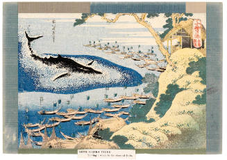
Whaling off Gotō (Gotō Kujira Tsuki), series One Thousand Pictures of the Ocean

Reported Dangers to navigation in the Pacific Ocean, inclusive of the China and Japan Seas and the...

TRAINING SHIPS OF THE JAPANESE NAVY VISITING WELLINGTON THIS WEEK IN THE COURSE OF A PACIFIC CRUISE
Seinan Taiheiyo seizu [Map of southwest Pacific Ocean] / compiled by Asahi Shinbunsha

Japan and its relation to the territory bordering on the Pacific Ocean

中尾之内 第壱号

川北之内 上

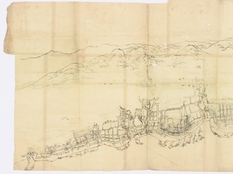
painting; handscroll
北海道測量図福山市街図

寺井津ノ内字浄盃全図

為重村之内字石塚分土居外全図
〔色丹島〕

東脊振村松隈字豆野全図
「辛丑春」
![Ma-ta : [estampe] / dessins de Georges Bigot](https://api.europeana.eu/thumbnail/v2/url.json?uri=https%3A%2F%2Fgallica.bnf.fr%2Fiiif%2Fark%3A%2F12148%2Fbtv1b105079538%2Ff1%2Ffull%2F512%2C%2F0%2Fnative.jpg&type=IMAGE)
Ma-ta : [estampe] / dessins de Georges Bigot
置戸村明細図(T12)
.jpg)
表紙
王晋郷/三白図
Album of Iconographic Drawings of the Esoteric Buddhist Pantheon (Shingon sect)
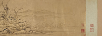
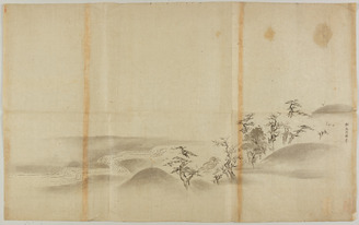
Landscape
Album of Iconographic Drawings of the Esoteric Buddhist Pantheon (Shingon sect)
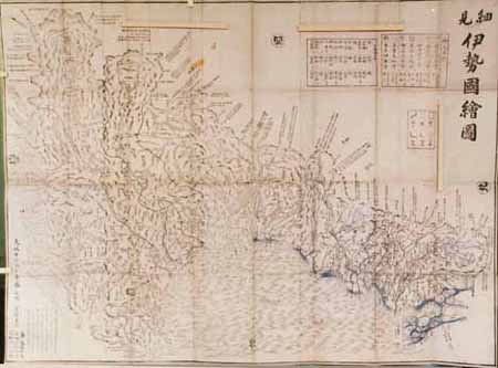
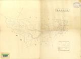
Saiken isenokuniezu
探幽/山水図
![Spring and Summer [right of a pair of Landscapes of the Four Seasons]](https://2.api.artsmia.org/60174.jpg)
Spring and Summer [right of a pair of Landscapes of the Four Seasons]
山水図屏風

hanging scroll; painting

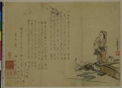
surimono; diptych print
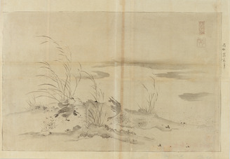
蘿窓/芦雁図
Gomanbun no ichi seibu Papua, Sarumi kinbō yōzu, nos. 1-3 (sheet 3)
Last Updated: 2020-06-05
Uploaded: 2021-07-22