Asia with the islands adioyning described, the atire of the people, & townes of importance, all of them newly augmented
- People
- Time
- Owner Organization
Asia with the islands adioyning described, the atire of the people & townes of importance, all of them newly augmented by I.S. Ano dom. 1626 / Sculptum apud Abrahamum Goos

Among the People of All Nations: Americans

A chart of the easternmost part of the East Indies with all the adjacent islands from Cape Comorin...
A new plaine and exact map of Asia / described by N.I. Vischer and rendered into English with habits of the countries and manner of the chiefe citties
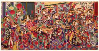
Merrymaking with All of the Flowers of the Yoshiwara Brothel District

Islands of Japan. (with) Japan, Mandshuria, (Showing the Course of the Amur River) The Kurile Isle...

Chinese and Japanese ports. (with) The mainland of Japan with the islands of Kiushiu & Shikoku. Ge...
Asia and its islands according to Danville : divided into empires, kingdoms, states, regions &ca. with the European possessions and settlements in the East Indies and an exact delineation of all the discoveries made in the Eastern parts by the English under Captn. Cook

A Map of Marco Polo's Voyages & Travels in the 13th Century trhough a great Part of Asia, all Tart...

A chart of the eastermost part of the East Indies with all the adjacent islands from Cape Comorin to Iapan / by Iohn Seller, Hydrographer to the King ; F. Lamb Sculp
Asia with its islands and different regions : according to their modern divisions ; also the discoveries made by Capt. Cook

A chart of the tradeing part of the East Indies and China, with the adjacent islands, from Surrat ...
A chart of the eastermost part of the East Indies with all the adjacent islands from Cape Comorin to Iapan / by Iohn Seller, Hydrographer to the King

map from "The Land of the Morning, an account of Japan and its people. ... With illustrations, etc"

map from "The Land of the Morning, an account of Japan and its people. ... With illustrations, etc"
Language is the proof of a people : a story about canoe making
Asia divided into its principall regions in which may be seen the extent of the empires, monarchies, kingdoms and states which at present divide Asia / described by Sanson ; corrected and amended by William Berry

A voyage of discovery to the North Pacific Ocean in which the coast of Asia, from the lat. of 35@ ...
A voyage of discovery to the North Pacific Ocean in which the coast of Asia, from the lat. of 35@ ...

Map of Asia

Map of Asia showing its Gt. Political Divisions, and, also, the Various routes of travel between L...

Charts, etc

Asia, Japan and Korea : with the surrounding seas and the adjacent coastal region of China / published at Wa...
WAR IN THE EAST This map shows Malaya and the Philippine Islands and the principal scenes of the Japanese of...
Last Updated: 2020-06-05
Uploaded: 2021-07-22