Reconnoissance of the Gulf and survey of the western shore of the Bay of Yedo / by order of Commodore M.C. Perry U.S.N. by Lieut. W.L. Maury and other officers of the U.S. Japan Expedition in 1853-54 ; drawn by Edw. Sels ; engr. by Selmar Siebert
- Time
- Owner Organization
Western shore of the Bay of Yedo / surveyed by order of Commodore M.C. Perry U.S.N. by Lieut. Wm. L. Maury and other officers of the Japan Expedition 1854 ; drawn by Edward Sels ; engraved by Selmar Siebert
Simoda Harbor, I. of Nippon / surveyed by order of Commodore M.C. Perry U.S.N. by Lieut. W.L. Maury, Lieut. Bent, Lieut. S. Nicholson, Act. Lieut. A. Barbot, Act. Mr. G.V. Denniston, Pd. Mdn. T.T. Houston in 1854 ; drawn by Edward Sels ; engraved by S. Siebert, lettering by C.A. Knight
The harbor of Hakodadi, Yesso Id. Japan / surveyed by order of Commodore M.C. Perry U.S.N. by Lieuts. W.L. Maury and G.H. Preble, S. Nicholson & A. Barbot in 1854 ; drawn by Edward Sels ; engraved by S. Siebert
Keelung Harbor, Formosa Island : surveyed by order of Commodore M.C. Perry U.S.N. / by Lieut. G.H. Preble & Pd. Md. Walter F. Jones in the U.S. Ship Macedonian Capt. J. Abbot. ; drawn by Edwd. Sels ; engr. by Selmar Siebert
Chart of the coast of China and of the Japan Islands including the Marianes and a part of the Philippines / compiled by order of Commodore M.C. Perry U.S.N. from the latest authorities with additions and corrections by the U.S. Japan Expedition by Lieuts. W.L. Maury and S. Bent U.S.N. ; drawn by Edw. Sels ; engr. by S. Siebert

Western shore of the Bay of Yedo / surveyed by order of Commodore M.C. Perry U.S.N. by Lieut. Wm. L. Maury a...
Chart of the world shewing the track of the U.S. steam frigates Mississippi, Susquehanna and Powhatan as flagships of the Japan Squadron under the command of Commodore M.C. Perry U.S.N. 1853-54 / drawn by Edw. Sels ; engr. by Selmar Siebert
Island of Lew Chew : surveyed by order of Commodore M.C. Perry U.S.N. / by W.B. Whiting, Silas Bent, G.B. Balch, I. Mathews & A. Barbot, Lieutenants U.S.N. ; drawing by Edward Sels ; engraved by Selmar Siebert
Shah Bay, Lew Chew I. surveyed by order of Commodore M.C. Perry U.S.N. / by Lieut. W.B. Whiting and Alph. Barbot of the U.S. Ship Vandalia, J. Pope Commr. ; engraved by Selmar Siebert ; drawn by S. Bent
The harbor of Napha, Lew Chew Id. surveyed by order of Commodore M.C. Perry U.S.N. / by Lieut. S. Bent assisted by F.S. Conover, J.W. Bennet and D. Ochiltree, Actg. Masters ; J.H. March, E.H. Grey, Pd. Midshipmen ; O.F. Stanton, W.F. Boardman, Midshipmen ; drawn by S. Bent ; engraved by Selmar Siebert
The Coffin Islands / surveyed by order of Commodore M.C. Perry U.S.N. by Lieuts. G.B. Balch, G.H. Cooper & L.A. Beardslee Mid. of the U.S. Ship Plymouth Commander John Kelly U.S.N. ; engraved by S. Siebert, lettering by C.A. Knight
Lew Chew Id. Deep Bay : surveyed by order of Commodore M.C. Perry U.S.N. / by Lieut. W.B. Whiting and A. Barbot, U.S. Ship Vandalia, J. Pope Commander ; engraved by S. Siebert, lettering by C.A. Knight
Map of the Japan Islands : copied from von Siebold's with slight additions & corrections, by the U.S. Japan Expedition and other authorities / Compiled by order of Commodore M.C. Perry, U.S.N. by Lieuts. W.L. Maury and Silas Bent ; James Ackerman, lith. 379 Broady NY
(Lew Chew) Tubootch & Suco Harbors / surveyed July 1854 by Lieuts. William B. Whiting and Alphonse Barbot, U.S.N. belonging to U.S. Ship Vandalia, John Pope Commander by Order of Commodore Matthew C. Perry Commanding U.S. Naval Forces in East Indies, China and Japan Seas ; drawn by Lieut. S. Bent ; engraved by S. Siebert, lettering by C.A. Knight
[Briefing charts of Japan] reproduced by 30th Engr. Top. Bn
Harbours in Kii Channel / Surveyed by Lieut. C. Bullock, J.H. Kerr, & G. Robinson, Masters, R.N. 1861. Engraved under the Direction of Captn. G.A. Bedford, R.N. by Davies & Powell
Map of Japan / by the Welcome Society ; engraved by H. Kobayashi

Chart of the Discoveries made in 1787, in the Seas of China and Tartary by the Boussole and Astrol...

THE CONFUSION IN THE TOWN OF PORT ARTHUR CAUSED BY THE BOMBARDMENT BY THE JAPANESE FLEET THE WAR IN THE FAR ...
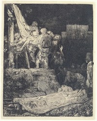
The Descent from the Cross by Torchlight
A chart of the northern part of the China Sea shewing the passage from Formosa to Japan with the eastern coast of China and the Lekeyo islands / by Van Kuelen ; improved from the maps drawn in China by Father Gaubil in 1752

Sanekadsura, a shrub, the infusion of the leaves whereof is used by some instead of the infusion of the Oren...

Chart of Discoveries made in 1787, in the Seas of China and Tartary, by the Boussole and Astrolabe...
.jpg)
THE LAND OF THE FREE — —from White Coolie, by Ronald Hastain, the sketch by Ronald Serale
Last Updated: 2020-06-05
Uploaded: 2021-07-22