
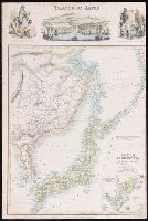
Japan, Mandshuria (Showing The Course of the Amur River) The Kurile Isles &c. Accroding to the Bri...
- People
- Time
- Owner Organization

Japan, Mandshuria (Showing The Course of the Amur River) The Kurile Isles &c. Accroding to the Bri...
Stanford University Libraries
Stanford Libraries SearchWorks
Islands of Japan
Yale University Library
Yale University Library Digital Collections

(Lower Sheet to) Map of the Island of Japan, Kurile &c. with the Adjacent Coasts of the Chinese Do...
Stanford University Libraries
Stanford Libraries SearchWorks
Map of the Island of Japan, Kurile &c. with the Adjacent Coasts of the Chinese Dominions and a Ske...
Stanford University Libraries
Stanford Libraries SearchWorks

Map of the Island of Japan, Kurile &c. with the Adjacent Coasts of the Chinese Dominions and a Ske...
Stanford University Libraries
Stanford Libraries SearchWorks
![[Japanese Red Cross taking care of enemy soldiers near the Amur River]](https://tile.loc.gov/storage-services/service/pnp/jpd/02500/02519_150px.jpg)
[Japanese Red Cross taking care of enemy soldiers near the Amur River]
Library of Congress
Digital Collections, Library of Congress
![[Japanese Red Cross taking care of enemy soldiers near the Amur River]](https://www.gumtree.com/static/1/resources/assets/rwd/images/orphans/a37b37d99e7cef805f354d47.noimage_thumbnail.png)
[Japanese Red Cross taking care of enemy soldiers near the Amur River]
Library of Congress
Trove: National Library of Australia

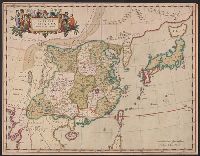
China, divided into its great provinces, and the Isles of Japan
Lionel Pincus and Princess Firyal Map Division. The New York Public Library
DPLA API

Grand Shrine of Ise, of the Highest Sanctity in Japan, Sacred to the Imperial Ancestress; Showing Pure Archa...
General Research Division. The New York Public Library
DPLA API
Appendix C - Documents Relating to the New Constitution of Japan
NDL Digital Collections
NDL Digital Collections

The Islands of Japan, by James Wyld,..
Bibliothèque nationale de France
Europeana API

The Islands of Japan, by James Wyld,..
Bibliothèque nationale de France
Europeana API

China divided into its great provinces and the Isles of Japan by Samuel Dunn
Yale University Library
Yale University Library Digital Collections

Japan, rice, showing the relative amount of production in colors, from light, lowest, to dark, highest
The Miriam and Ira D. Wallach Division of Art, Prints and Photographs. The New York Public Library
DPLA API

Japan, silk, showing the relative amount of production in colors, from light, lowest, to dark, highest
The Miriam and Ira D. Wallach Division of Art, Prints and Photographs. The New York Public Library
DPLA API

Cartoon, 'To the citizens of Japan and Sendai'
Museum of New Zealand Te Papa Tongarewa
DigitalNZ New Zealand API

Cartoon, 'To the citizens of Japan and Sendai'
Museum of New Zealand Te Papa Tongarewa
DigitalNZ New Zealand API

Wrestling, the popular Japanese sport - showing one of the effective "holds" - Tokyo, Japan
Library of Congress
Digital Collections, Library of Congress

(Map of the Ishikari plains, Japan). (to accompany) Shomitsu Nippon chizu. (Atlas of Japan). Nippo...
Stanford University Libraries
Stanford Libraries SearchWorks

The Empire of China and Island of Japan, Agreeable to Modern History
Stanford University Libraries
Stanford Libraries SearchWorks

Colton's Japan Nippon, Kiusiu, Sikok,Yesso and the Japanese Kuriles
Stanford University Libraries
Stanford Libraries SearchWorks

Colton's Japan Nippon, Kiusiu, Sikok,Yesso and the Japanese Kuriles
Stanford University Libraries
Stanford Libraries SearchWorks
The 'Western Pacific, showing the geographical relationship of Japan, French Indo-China, the Netherlands Eas...
National Library of New Zealand
DigitalNZ New Zealand API

Japan Nippon, Kiusiu, Sikok, Yesso And The Japanese Kuriles. (with) two inset maps: Yesso And The ...
Stanford University Libraries
Stanford Libraries SearchWorks
Japan, Mandshuria (Showing The Course of the Amur River) The Kurile Isles &c. Accroding to the Bri...
Stanford University Libraries
Stanford Libraries SearchWorks
Himekomatsunenohinoasobi、ogurinohangankurumakaidou
Museum of Fine Arts, Boston
ARC Banzuke (Playbills) Portal Database

A New Map of India & China From the latest Observations
Stanford University Libraries
Stanford Libraries SearchWorks
Imperii Sinarum nova descriptio
Yale University Library
Yale University Library Digital Collections

Carte Des Indes et de la Chine Dressee sur plusieurs Rectifees par quelques Observations Par Guill...
Stanford University Libraries
Stanford Libraries SearchWorks
Raifukujinohana
Nationaal Museum van Wereldculturen (Rijksmuseum Volkenkunde, Leiden)
ARC Ukiyo-e Portal Database

A New Map of Chinese & Independent Tartary, From The Latest Authorities . . . 1806
Stanford University Libraries
Stanford Libraries SearchWorks

〔富士山三尊九尊来迎図〕
Mt.Fuji World Heritage Center, Shizuoka
ADEAC: A System of Digitalization and Exhibition for Archive Collections

China (Ostl. Theil), Korea Und Japan Im Maassstabe Von 1:7.500.000. Von A Petermann. Bearbeitet vo...
Stanford University Libraries
Stanford Libraries SearchWorks

Carte Nouvelle de Tout L'Empire de la Grande Russie Dans L'Estat Ou Il S'Este Trouve A La Mort De ...
Stanford University Libraries
Stanford Libraries SearchWorks

Plan de la ville et du port de Nangasaki d'après un ancien Plan Japonais réduit à moitié de l'Orig...
Bibliothèque nationale de France
Europeana API

1904 war map of Russia and the continent of Asia
Yale University Library
Yale University Library Digital Collections

L'empire du Japon divisé en sept principales parties, et subdivisé en soixante et six royaumes / p...
Bibliothèque nationale de France
Europeana API

Carte Des Indes et de la Chine Dressee sur plusieurs Relations particulieres Rectifees par quelque...
Stanford University Libraries
Stanford Libraries SearchWorks

Corea and Japan
Stanford University Libraries
Stanford Libraries SearchWorks

「安芸厳島神社之図」
Tokyo Metropolitan Central Library
ARC Ukiyo-e Portal Database
Last Updated: 2020-04-17
Uploaded: 2021-09-21