
China and Japan. Drawn and Engraved for Dr. Playfair's Geography. Engraved by H. Cooper, 28 Chance...
- People
- Time
- Owner Organization
China and Japan / drawn and engraved for Dr. Playfair's Geography; engraved by H. Cooper, 28 Chancery Lane
National Library of Australia
Trove: National Library of Australia

China and Japan. London: Published by Henry Teesdale & Co. Drawn & Engraved by J. Dower, Pentonvil...
Stanford University Libraries
Stanford Libraries SearchWorks

China and Japan. Drawn & engraved by J. Dower. London, Published by Henry Teesdale & Co. (to accom...
Stanford University Libraries
Stanford Libraries SearchWorks

Corea and Japan. J. & G. Menzies sculpt., Edinr. Drawn & engraved for Thomson's New general atlas,...
Stanford University Libraries
Stanford Libraries SearchWorks
North Pacific Ocean / compiled & drawn by J.W. Appleton ; engraved by Homewood & Son
National Library of Australia
Trove: National Library of Australia

Japan. Drawn by A. Arrowsmith. Engraved by Sidy. Hall. Published, 1817, by A Constable & Co. Edinb...
Stanford University Libraries
Stanford Libraries SearchWorks
A new & accurate map of Asia : drawn from the most approved modern maps & charts / by Thos. Bowen ; engraved for Middletons complete system of geography
National Library of Australia
Trove: National Library of Australia

Map of the Empire of China and Japan. J.W. del. (engraved by) Stockley, Sc London, James Wyld, Cha...
Stanford University Libraries
Stanford Libraries SearchWorks
Abel Tasman and his journal... / [by Dr. Hocken]
National Library of Australia
Trove: National Library of Australia

China, Engraved Expressly for the Standard World Atlas. (inset) Japan or Nippon
Stanford University Libraries
Stanford Libraries SearchWorks
The harbor of Hakodadi, Yesso Id. Japan / surveyed by order of Commodore M.C. Perry U.S.N. by Lieuts. W.L. Maury and G.H. Preble, S. Nicholson & A. Barbot in 1854 ; drawn by Edward Sels ; engraved by S. Siebert
National Library of Australia
Trove: National Library of Australia
Members of 28 (Maori) Battalion in line for patriotic parcels, near Tripoli - Photograph taken by Dr C N D'A...
Alexander Turnbull Library
DigitalNZ New Zealand API
Shah Bay, Lew Chew I. surveyed by order of Commodore M.C. Perry U.S.N. / by Lieut. W.B. Whiting and Alph. Barbot of the U.S. Ship Vandalia, J. Pope Commr. ; engraved by Selmar Siebert ; drawn by S. Bent
National Library of Australia
Trove: National Library of Australia

Part of Japan or Nipon. (with) View of the coast of Japan when we first saw it (Engraved by) W. H(...
Stanford University Libraries
Stanford Libraries SearchWorks

Japan / drawn under the direction of Mr. Pinkerton by L. Hebert ; Neele sculpt
Yale University Library
Yale University Library Digital Collections
China and Japan with adjoining countries / compiled and published by H.E.C.Robinson Pty. Ltd
National Library of Australia
Trove: National Library of Australia
View from 28 (Maori) Battalion Regimental Aid Post in entrance to crypt, Cassino - Photograph taken by Dr C ...
Alexander Turnbull Library
DigitalNZ New Zealand API

China divided into its great provinces and the Isles of Japan by Samuel Dunn
Yale University Library
Yale University Library Digital Collections
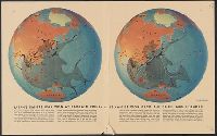
Japan's empire was won at bargain prices... / drawn by Richard Edes Harrison
Yale University Library
Yale University Library Digital Collections
Members of 28 (Maori) Battalion with German staff car, El Alamein, Egypt - Photograph taken by Dr C N D'Arcy
Alexander Turnbull Library
DigitalNZ New Zealand API

A map of the Empire of Japan, made by Dr. Kaempfer [with maps of Kamchatka, Northern coast of Japan, as well...
General Research Division. The New York Public Library
DPLA API

Japan. Drawn under the direction of Mr. Pinkerton by L. Hebert. Neele sculpt 352 Strand. London: p...
Stanford University Libraries
Stanford Libraries SearchWorks
Regimental Aid Post of the 28 (Maori) Battalion in the New Zealand Box, El Alamein - Photograph taken by Dr ...
Alexander Turnbull Library
DigitalNZ New Zealand API

Farmers of forty centuries; or, Permanent agriculture in China, Korea and Japan. Edited by J.P. Br...
Library of Congress
Europeana API

Das Chinesische Reich und das Kaiserthum Japan. (Chinese Empire and Japan.)
Stanford University Libraries
Stanford Libraries SearchWorks

The Kingdome of China
Stanford University Libraries
Stanford Libraries SearchWorks

Tabula Tartariae et majoris partis Regni Chinae
Stanford University Libraries
Stanford Libraries SearchWorks
Pas-caert van't Oostelyckste deel van Oost Indien : met alle de Eylanden daer onder gelegen, van Cabo Comorin tot aen Japan / by Hendrick Doncker Boekverkooper en Graadbooghmaacker Inde Nieuwbrughsteegh
National Library of Australia
Trove: National Library of Australia

Das Chinesische Reich mit seinen Schutzstaaten, den Landern der Mandschu und Mongolen, Ost Turkist...
Stanford University Libraries
Stanford Libraries SearchWorks
China and Japan. Drawn & engraved by J. Dower. London, Published by Henry Teesdale & Co. (to accom...
Stanford University Libraries
Stanford Libraries SearchWorks

「猿ヶ島敵討之図」
British Museum
ARC Ukiyo-e Portal Database

「大仏耳塚」
C. V. Starr East Asian Library, University of California, Berkeley
ARC Ukiyo-e Portal Database

Tatariae Sinensis Mappa Geographica ex Tabulis secialibus R.R.P.P. Iesuitarum nec non Relationibus...
Stanford University Libraries
Stanford Libraries SearchWorks

「秋津洲」
C. V. Starr East Asian Library, University of California, Berkeley
ARC Ukiyo-e Portal Database

The Empire of Japan Divided into Seven Principal Parts and Subdivided ino Sixty Six Kingdoms; with...
Stanford University Libraries
Stanford Libraries SearchWorks

China and Japan. (with) Islands of Japan. By Keith Johnston, F.R.S.E. Keith Johnston's General Atl...
Stanford University Libraries
Stanford Libraries SearchWorks

Das Chinesische Reich Mit Seinen Schutzstaaten Nebst Dem Japanishcen Inselreiche. . . .1833
Stanford University Libraries
Stanford Libraries SearchWorks
Last Updated: 2020-04-17
Uploaded: 2021-09-21