
Map of Asia showing its gt. political divisions, and also the various routes of travel between Lon...
- Time
- Owner Organization

Map of Asia showing its gt. political divisions, and also the various routes of travel between Lon...

Map of Asia showing its gt. political divisions, and also the various routes of travel between Lon...

Map Of Asia Showing its Gt. Political Divisions, and also the Various Routes of Travel Between Lon...

Map Of Asia Showing its Gt. Political Divisions, and also the Various Routes of Travel Between Lon...

Map of Asia showing its gt. political divisions, and also various routes of travel between London ...

Map of Asia showing its gt. political divisions, and also various routes of travel between London ...

Map of Asia showing its gt. political divisions, and also various routes of travel between London ...

Map of Asia Showing its Gt. Political Divisions, and, also, the Various routes of Travel Between L...

Map of Asia showing its Gt. Political Divisions, and, also, the Various routes of travel between L...

Map of Asia Showing its Gt. Political Divisions and...Routes of Trade between London & India, Chin...

Map of Asia Showing its Gt. Political Divisions and...Routes of Trade between London & India, Chin...

Map of Asia Showing its Gt. Political Divisions and...Routes of Trade between London & India, Chin...

Map of Asia Showing its Gt. Political Divisions and...Routes of Trade between London & India, Chin...
![Tokyo : [base map showing political divisions]](https://stacks.stanford.edu/image/iiif/jw443fg4075%2Fjw443fg4075_00_0001/full/!200,200/0/default.jpg)
Tokyo : [base map showing political divisions]
![Osaka : [base map showing political divisions]](https://stacks.stanford.edu/image/iiif/rk252rh2515%2Frk252rh2515_00_0001/full/!200,200/0/default.jpg)
Osaka : [base map showing political divisions]
![Yokohama : [base map showing political divisions]](https://stacks.stanford.edu/image/iiif/hg765ms3579%2Fhg765ms3579_00_0001/full/!200,200/0/default.jpg)
Yokohama : [base map showing political divisions]
Court Exh. No. 2570: Map showing various sectors or divisions of the city of Hankow, and showing the various routes of entry of the several units and their disposition
Court Exh. No. 2570: Map showing various sectors or divisions of the city of Hankow, and showing the various routes of entry of the several units and their disposition
Stanford's London atlas of universal geography exhibiting the physical and political divisions of the various countries of the world
Asia with its islands and different regions : according to their modern divisions ; also the discoveries made by Capt. Cook

Welfare map of Peiping : also showing other points if interest. (Drawn by) Atterburt

Illustration showing various kinds of discoloration of the lips due to smallpox

Asia distinguished into its principall parts

Eastern Asia, showing Japan, Korea, Manchuria and adjoining parts of Siberia and China. 185 miles ...
Map of Asia showing its Gt. Political Divisions, and, also, the Various routes of travel between L...
Map of Asia showing its gt. political divisions, and also the various routes of travel between Lon...
Map of Asia Showing its Gt. Political Divisions, and, also, the Various routes of Travel Between L...
Map of Asia showing its gt. political divisions, and also the various routes of travel between Lon...

Chinese Empire and Japan
Map of Asia showing its gt. political divisions, and also various routes of travel between London ...
Map Of Asia Showing its Gt. Political Divisions, and also the Various Routes of Travel Between Lon...
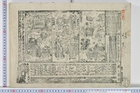
Shidayakatamitsuginofunauta

Chinese Empire And Japan

Asia (Eastern Sheet)
Map of Asia showing its gt. political divisions, and also various routes of travel between London ...
Banzeiokunikabuki

Japan

China and Japan

Chinae, olim Sinarum regionis nova descriptio auctore Ludovico Georgio . . . 1584
Ieyasu - Schrein, Holztafel (Tür) (Nikko Toshogu)

Sharpe's Corresponding Maps. South Eastern Asia. Birmah - China - Japan London - Published by Chap...
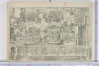
![[はなだすきがんりゅうじま]、[きくじどうしょさごと]](http://mfas3.s3.amazonaws.com/styles/grid-2_thumbnail_retina/s3/objects/SC209350.jpg)
[はなだすきがんりゅうじま]、[きくじどうしょさごと]
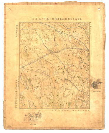
東京府管下武蔵國東多摩郡上高井戸村近傍

Carte de L'Empire Chinois et du Japon
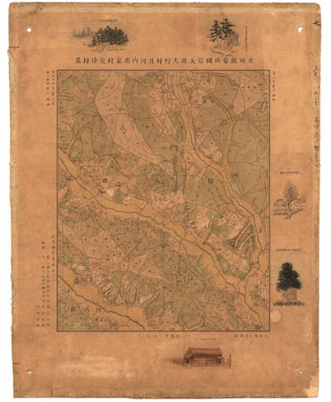
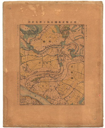
茨城縣常陸國信太郡久野村及河内郡泉村近傍村落
![[はなだすきがんりゅうじま]、[きくじどうしょさごと]](http://mfas3.s3.amazonaws.com/styles/grid-2_thumbnail_retina/s3/objects/SC209318.jpg)
[はなだすきがんりゅうじま]、[きくじどうしょさごと]
埼玉縣武蔵國北埼玉郡麦倉村

Chinese Empire And Japan. Entered ... 1835 by Thomas Illman ... New York
Last Updated: 2020-04-17
Uploaded: 2021-09-21