
China divided into its Great Provinces, and The Isle of Japan . . . 1774
- People
- Time
- Owner Organization

China, divided into its great provinces, and the Isles of Japan
China Divided into its Great Provinces and the Isles of Japan [Material cartográfico]

China divided into its great provinces and the Isles of Japan by Samuel Dunn
The Empire of Japan : divided into seven principal parts and subdivided into sixty six Kingdoms : ...
The empire of Japan divided into seven principal parts and subdivided into six kingdoms with the k...
The Empire of Japan divided into seven principal parts and subdivided into sixty six kingdoms : wi...

The Empire of Japan divided into seven principal parts and subdivided into sixty-six kingdoms; wit...

Asia According to the Sieur D'Anville Divided into its Empires, Kingdoms and States Showing the Eu...

The Empire of Japan Divided into Seven Principal Parts and Subdivided ino Sixty Six Kingdoms; with...

Asia distinguished into its principall parts

The Sixty-odd Provinces of Japan, a Catalogue of Famous Sites Shown at a Single Glance and Divided into a Game Board
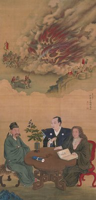
A Meeting of Japan, China, and the West

China, Contains 15 Subject Provinces, including the 2 Islands of Hainan Formosa and the Tributary ...

China, Contains 15 Subject Provinces, including the 2 Islands of Hainan Formosa and the Tributary ...

China, Contains 15 Subject Provinces, including the 2 Islands of Hainan Formosa and the Tributary ...

China, Contains 15 Subject Provinces, including the 2 Islands of Hainan Formosa and the Tributary ...

A New Mapp of ye Empire of China With its severall Provinces or kingdomes, Together wth. the adjac...

Chart of the coast of China and of the Japan islands including the Marianes and part of the Philippines
Asia divided into its principall regions in which may be seen the extent of the empires, monarchies, kingdoms and states which at present divide Asia / described by Sanson ; corrected and amended by William Berry
Japan, the islands of Loochoo & Formosa, and the maritime provinces of China with the tract of the Morrison's voyage in 1837 / J. Arrowsmith, Lith
The land of the morning: an account of Japan and its people

Fankwei; or, the San Jacinto in the seas of India, China and Japan

The Empire of China and Island of Japan, Agreeable to Modern History

Report on the ichthyology of the seas of China and Japan /

L'Empire de la Chine d'après l'Atlas Chinois avec les Isles du Japon . .

Asia According to the best Authorities

Sibérie, partie de l'empire chinois, îles du Japon / par Fx Delamarche, fils

L'Empire de la Chine d'après l'Atlas Chinois avec les Isles du Japon . .

Map of the Empire of China and Japan. J.W. del. (engraved by) Stockley, Sc London, James Wyld, Cha...
China, Contains 15 Subject Provinces, including the 2 Islands of Hainan Formosa and the Tributary ...

Das Chinesische Reich mit seinen Schutzstaaten (den Ländern der Mandschu und Mongolen, Ost Turkist...

Carte De La Coree et Du Japon
China veteribus Sinarum Regio nunc incolis Tame dicta
Imperii Sinarum nova descriptio [prepared by Martino Martini]

Royaume du Japon

L'Empire de la Chine d'après l'Atlas Chinois avec les Isles du Japon . .

Mandchourie et Coree de Kharbine a Seoul de Port-Arthur a Vladivostok Traduction de la Carte d'Eta...

Carte de l'Asie orientale comprenant l'empire chinois le Japon les états de l'Indo-Chine et le gra...

Carte Des Indes et de la Chine Dressee sur plusieurs Rectifees par quelques Observations Par Guill...

India : quae orientalis dicitur et insulae adiacentes

Carte de L'Asie selon le auteurs Anciens enrichie de Remarques Historiques sur les changemens qui ...

Ost-Indien
![Carte De L'Empire De La Chine . . . An XII [Shows Formosa]](https://stacks.stanford.edu/image/iiif/qv486bn8087%2F18739/full/!200,200/0/default.jpg)
Carte De L'Empire De La Chine . . . An XII [Shows Formosa]

China and Japan

Carte des Indes Orientales . . . 1677

Tartarie Chinoise, Roy, De Coree et Isles Du Japon
![Keijō Kinbō [cartographic material]](https://stacks.stanford.edu/image/iiif/jk515ck5320%2Fjk515ck5320_00_0001/full/!200,200/0/default.jpg)
Keijō Kinbō [cartographic material]
Tabula Tartariae et majoris partis regni Chinae / edita a F. de Wit ; Lhuilier fecit
Last Updated: 2020-04-17
Uploaded: 2021-09-21