
Karta Aziatskoi Rossii . . . [Map of the Asian part of Russia and Possessions Adjacent, with the R...
- People
- Time
- Owner Organization
Stanford's map of the empires of China and Japan : with the adjacent parts of the Russian Empire, ...

(Composite Map of) Map of the Island of Japan, Kurile &c. with the Adjacent Coasts of the Chinese ...

A chart of the tradeing part of the East Indies and China, with the adjacent islands, from Surrat ...

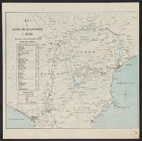
[Transport Map of Russia: 'Map of the routes of Steamships, Communication lines, Railways and Road...

A Map of the East-Indies and the Adjacent Countries; with the Settlements, Factories and Territori...

A Map of the East-Indies and the Adjacent Countries; with the Settlements, Factories and Territori...

A Map of the East-Indies and the Adjacent Countries; with the Settlements, Factories and Territori...

A Map of the East-Indies and the Adjacent Countries; with the Settlements, Factories and Territori...

A Map of the East-Indies and the Adjacent Countries; with the Settlements, Factories and Territori...

A Map of the East-Indies and the Adjacent Countries; with the Settlements, Factories and Territori...

Map of the Island of Japan, Kurile &c. with the Adjacent Coasts of the Chinese Dominions and a Ske...

Map of the Island of Japan, Kurile &c. with the Adjacent Coasts of the Chinese Dominions and a Ske...

(Upper Sheet to) Map of the Island of Japan, Kurile &c. with the Adjacent Coasts of the Chinese Do...
(Lower Sheet to) Map of the Island of Japan, Kurile &c. with the Adjacent Coasts of the Chinese Do...
Stanford's map of the empires of China and Japan with the adjacent parts of the Russian Empire, India, Burma &c / Stanford's Geogl. Estabt
Stanford's map of China & Japan with the adjacent parts of the Russian Repubcs. India, Burma &c / Stanford's Geographical Establishment

Geologic map of the eastern part of Hakone Volcano
Map and guide of Hakone and neighbourhood

A chart of the easternmost part of the East Indies with all the adjacent islands from Cape Comorin...

Charts, etc

Asia, Japan and Korea : with the surrounding seas and the adjacent coastal region of China / published at Wa...

Map of Edo and Its Environs

A map of the city of Nagasaki, and of the adjacent country; Sorts of money current in the Japanese Empire

General map of China and adjacent regions, showing treaty ports and railways
![Empire of Japan [C & J Favre Brandt, Yokohama]](https://stacks.stanford.edu/image/iiif/sf796wm2159%2F25128/full/!200,200/0/default.jpg)
Empire of Japan [C & J Favre Brandt, Yokohama]

「秋津洲」

「里俗相伝而西湖之八詠在金沢云其景光如図」

Karta Aziatskoi Rossii i smezhnykhi s neiu vladenii : S ukazanem puti sldovaniia Gosudaria Imperat...
唐子遊び

冨士登山口全図
Seven Sages of the Bamboo Grove

Map of Asia Showing its Gt. Political Divisions, and, also, the Various routes of Travel Between L...

「浅草御坊御遷仏略図」
Shidayakatamitsuginofunauta

Hanging scroll
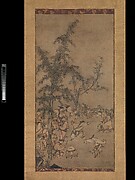
Fenggan, Hanshan, and Shide

The history of Japan, giving an account of the ancient and present state and government of that empire; of i...

「SOSANO KILLS THE EIGHT HEADED DRAGON AND SAVES INADA HIME」
松に山鳩

Tatariae Sinensis Mappa Geographica ex Tabulis secialibus R.R.P.P. Iesuitarum nec non Relationibus...

Kuniyoshi's preparatory drawings, no.39

「新撰仮名手本忠臣蔵」

谷文晁像

Carte de la Tartarie Chinoise. Projettee et assujettie aux observations astronomiques par M. Bonne...

Map of Asia showing its Gt. Political Divisions, and, also, the Various routes of travel between L...

「真洲先稲荷」「隅田川眺望」
Gotaiheikishiraishibanashi
![Shina busshi ryūdo sōgō zu [cartographic material]](https://stacks.stanford.edu/image/iiif/sy422nt0000%2Fsy422nt0000_00_0001/full/!200,200/0/default.jpg)
Shina busshi ryūdo sōgō zu [cartographic material]
Last Updated: 2020-04-17
Uploaded: 2021-09-21