
Rand McNally map of Eastern Asia and Western Pacific Ocean. (Mercator projection). Copyright by Ra...
- Time
- Owner Organization

Rand McNally map of Eastern Asia and Western Pacific Ocean. Mercator projection. Copyright by Rand...
Stanford University Libraries
Stanford Libraries SearchWorks

Rand, McNally & Company's indexed atlas of the world map of Japan Copyright 1892, by Rand, McNally...
Stanford University Libraries
Stanford Libraries SearchWorks
![[World War II battlefronts]. Map VI. The Southwest Pacific. Copyright, 1944, by Remington Rand, In...](https://stacks.stanford.edu/image/iiif/vs321mz7073%2F6758006/full/!200,200/0/default.jpg)
[World War II battlefronts]. Map VI. The Southwest Pacific. Copyright, 1944, by Remington Rand, In...
Stanford University Libraries
Stanford Libraries SearchWorks

Map of the Pacific Ocean
Philadelphia Museum of Art
Philadelphia Museum of Art collection
Seinan Taiheiyo seizu [Map of southwest Pacific Ocean] / compiled by Asahi Shinbunsha
National Library of Australia
Trove: National Library of Australia
Hagstrom's map of the Pacific and the Far East : on Mercator's projection
National Library of Australia
Trove: National Library of Australia

Dated Events. On To Tokyo. Map of the Pacific and the Far East. Stanley Turner, 44. Copyright, Can...
Stanford University Libraries
Stanford Libraries SearchWorks
![Japan and adjacent regions of Asia and the Pacific Ocean [cartographic material] / compiled and drawn in the...](https://collections.library.yale.edu/iiif/2/15510875/full/!200,200/0/default.jpg)
Japan and adjacent regions of Asia and the Pacific Ocean [cartographic material] / compiled and drawn in the...
Yale University Library
Yale University Library Digital Collections
![Japan and adjacent regions of Asia and the Pacific Ocean [cartographic material] / compiled and drawn in the...](https://collections.library.yale.edu/iiif/2/15509964/full/!200,200/0/default.jpg)
Japan and adjacent regions of Asia and the Pacific Ocean [cartographic material] / compiled and drawn in the...
Yale University Library
Yale University Library Digital Collections
North Pacific Ocean / compiled & drawn by J.W. Appleton ; engraved by Homewood & Son
National Library of Australia
Trove: National Library of Australia

(Composite of) A New Chart of The Pacific Ocean, Exhibiting The Western Coast of America, From Cap...
Stanford University Libraries
Stanford Libraries SearchWorks

A New Chart of The Pacific Ocean, Exhibiting The Western Coast of America from Cape Horn to Beerin...
Stanford University Libraries
Stanford Libraries SearchWorks
Span of the U.S. in the Pacific / news map by staff artist Sundberg
National Library of Australia
Trove: National Library of Australia

A New Chart of The Pacific Ocean, Exhibiting The Western Coast of America, From Cape Horn To Beeri...
Stanford University Libraries
Stanford Libraries SearchWorks

A New Chart of The Pacific Ocean, Exhibiting The Western Coast of America, From Cape Horn To Beeri...
Stanford University Libraries
Stanford Libraries SearchWorks
Japan and adjacent regions of Asia and the Pacific Ocean / compiled and drawn in the Cartographic Section of the National Geographic Society
National Library of Australia
Trove: National Library of Australia

A voyage of discovery to the North Pacific Ocean in which the coast of Asia, from the lat. of 35@ ...
Canadiana.org
Europeana API
A voyage of discovery to the North Pacific Ocean in which the coast of Asia, from the lat. of 35@ ...
Canadiana.org
Europeana API
A new chart of the Pacific Ocean : exhibiting the western coast of America, from Cape Horn to Beerings Strait, the eastern shores of Asia including Japan, China and Australia and all the numerous islands and known dangers situated in Polynesia and Australasia / correctly drawn and regulated according to the most approved and modern surveys and astronomical observations by J.W. Norie
State Library of New South Wales
Trove: National Library of Australia

Kagoshima, Kagoshima Prefecture, Kyushu, Japan
Stanford University Libraries
Stanford Libraries SearchWorks

A New and Correct Chart of all the Known World Laid down according to Mercator's Projection
Stanford University Libraries
Stanford Libraries SearchWorks

Hikone, Shiga Prefecture, Honshu, Japan
Stanford University Libraries
Stanford Libraries SearchWorks

Oost Indien Wassende-Graade Paskaart, vertoonende nevens het Oosterlykste van Afrika, meede de Zee...
Stanford University Libraries
Stanford Libraries SearchWorks
China and Japan
VU University Amsterdam Library
Europeana API

Carte des Indes, de la Chine & des Iles de Sumatra, Java &c.
Stanford University Libraries
Stanford Libraries SearchWorks

A New and Correct Chart of all the Known World Laid down according to Mercator's Projection
Stanford University Libraries
Stanford Libraries SearchWorks
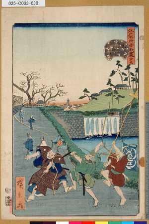
「江戸名所道戯盡」 「廿九」「虎の御門外の景」
Tokyo Metropolitan Central Library
ARC Ukiyo-e Portal Database

Meishoedohyakkeikasumigaseki
Art Institute of Chicago
ARC Ukiyo-e Portal Database

Karte von Australien oder Polynesien, nach den Zeichnungen, Reisebe Schreibungen und Tagebucher de...
Stanford University Libraries
Stanford Libraries SearchWorks

Carte Des Indes et de la Chine Dressee sur plusieurs Relations particulieres Rectifees par quelque...
Stanford University Libraries
Stanford Libraries SearchWorks
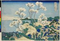
「富嶽三十六景」 「東海道品川御殿山ノ不二」
British Museum
ARC Ukiyo-e Portal Database
Last Updated: 2020-04-17
Uploaded: 2021-09-21