
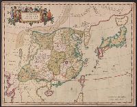
China, Contains 15 Subject Provinces, including the 2 Islands of Hainan Formosa and the Tributary ...
- People
- Time
- Owner Organization

China, Contains 15 Subject Provinces, including the 2 Islands of Hainan Formosa and the Tributary ...

China, Contains 15 Subject Provinces, including the 2 Islands of Hainan Formosa and the Tributary ...

China, Contains 15 Subject Provinces, including the 2 Islands of Hainan Formosa and the Tributary ...

Figures and descriptions of the fishes of Japan : including Riukiu Islands, Bonin Islands, Formosa...
Figures and descriptions of the fishes of Japan : including Riukiu Islands, Bonin Islands, Formosa...

Chart of the coast of China and of the Japan islands including the Marianes and part of the Philippines
Japan, the islands of Loochoo & Formosa, and the maritime provinces of China with the tract of the Morrison's voyage in 1837 / J. Arrowsmith, Lith

Sketch of a voyage to the India and China seas, including Japan and the Pacific islands, for the p...

North West Pacific Ocean : Including Yellow, Japan & Okhotsk Seas, the Kuril Islands and Kamchatka

639/* Celebes, Halmaheras (Including Morotai) and Adjacent Islands >> 639/5/2 [Celebes, Halm...

639/* Celebes, Halmaheras (Including Morotai) and Adjacent Islands >> 639/8/2 [Celebes, Halm...

639/* Celebes, Halmaheras (Including Morotai) and Adjacent Islands >> 639/9/2 [Celebes, Halm...
A chart of the northern part of the China Sea shewing the passage from Formosa to Japan : with the eastern coast of China and the Lekeyo Islands

China divided into its great provinces and the Isles of Japan by Samuel Dunn
A chart of the northern part of the China Sea shewing the passage from Formosa to Japan with the eastern coast of China and the Lekeyo islands / by Van Kuelen ; improved from the maps drawn in China by Father Gaubil in 1752
A new mapp of y Empire of China : with its several provinces or kingdomes together w.th [i.e. with] the adjacent Isles of Iapon or Niphon, Formosa, Hainan, etc. / rendred into English & enlarged w.th the Isles of Iapon by Rich. [i.e. Richard] Blome by his Majesties command ; W. Hollar fecit 1669
Prisoner of war supply missions to China, Korea, Formosa, Manchuria and the Japanese Home Islands, 27 August-20 September 1945. Report No. 2-b(75), USSBS Index; Section 7
Chart of the coast of China and of the Japan Islands including the Marianes and a part of the Philippines / compiled by order of Commodore M.C. Perry U.S.N. from the latest authorities with additions and corrections by the U.S. Japan Expedition by Lieuts. W.L. Maury and S. Bent U.S.N. ; drawn by Edw. Sels ; engr. by S. Siebert
A new chart of the Pacific Ocean : exhibiting the western coast of America, from Cape Horn to Beerings Strait, the eastern shores of Asia including Japan, China and Australia and all the numerous islands and known dangers situated in Polynesia and Australasia / correctly drawn and regulated according to the most approved and modern surveys and astronomical observations by J.W. Norie
China, Contains 15 Subject Provinces, including the 2 Islands of Hainan Formosa and the Tributary ...
China, Contains 15 Subject Provinces, including the 2 Islands of Hainan Formosa and the Tributary ...

1904 war map of Russia and the continent of Asia

A New Map of Great Tartary and China, with the adjoyning Parts of Asia, Taken from Mr. De Fer's Ma...

A New and Accurate Map of the Colony of Massachusets Bay, In North America from a Late Survey

Asiae Nova Delineatio . .

Asia Concinnata Secundum Observationes Academiae Regalis Scientiarum . .

Nieuwe Kaart van't Keizerryk. Japan na de Nieuste ontdekkingen

Tartariae Sive Magni Chami Regni typus
Imperii Sinarum nova descriptio

Asia (Eastern Sheet)

Indiae Orientalis Insularumque Adiacientium Typus

Asiae Recentissima Delineatio Qua Status et Imperia Totius Orientis unacum Orientalibus Indiis…

Indiae Orientalis Insularumque Adiacientium Typus

To the Right Honorable William Lord Cowper Lord High Chancellor of Great Britain This Map of Asia ...

Insularum Japoniae

Asiae Nova Descriptio

Tartariae Sive Magni Chami Regni typus

L'Empire de la Chine, avec les Isles Du Japon, et la Corree

Imperium Japonicum in sexaginta et octo provincias divisum ex ipsorum Japonensium mappis & observationibus K...

Chinese Empire & Japan

Asia

Indiae Orientalis Insularumque Adiacientium Typus

Map Of Asia Showing its Gt. Political Divisions, and also the Various Routes of Travel Between Lon...
Last Updated: 2020-04-17
Uploaded: 2021-09-21