
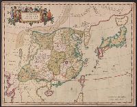
China, Contains 15 Subject Provinces, including the 2 Islands of Hainan Formosa and the Tributary ...
- People
- Time
- Owner Organization

China, Contains 15 Subject Provinces, including the 2 Islands of Hainan Formosa and the Tributary ...
Stanford University Libraries
Stanford Libraries SearchWorks

Figures and descriptions of the fishes of Japan : including Riukiu Islands, Bonin Islands, Formosa...
スミソニアン図書館
Europeana API
Japan, the islands of Loochoo & Formosa, and the maritime provinces of China with the tract of the Morrison's voyage in 1837 / J. Arrowsmith, Lith
National Library of Australia
Trove: National Library of Australia

Sketch of a voyage to the India and China seas, including Japan and the Pacific islands, for the p...
Research Libraries UK
Europeana API

639/* Celebes, Halmaheras (Including Morotai) and Adjacent Islands >> 639/5/2 [Celebes, Halm...
Nationaal Archief
Europeana API

639/* Celebes, Halmaheras (Including Morotai) and Adjacent Islands >> 639/8/2 [Celebes, Halm...
Nationaal Archief
Europeana API

639/* Celebes, Halmaheras (Including Morotai) and Adjacent Islands >> 639/9/2 [Celebes, Halm...
Nationaal Archief
Europeana API

China, divided into its great provinces, and the Isles of Japan
Lionel Pincus and Princess Firyal Map Division. The New York Public Library
DPLA API

China divided into its great provinces and the Isles of Japan by Samuel Dunn
Yale University Library
Yale University Library Digital Collections
The Philippine Islands, Molucas, Siam, Cambodia, Japan and China, at the close of the sixteenth ce...
Biblioteca Nacional de España
Europeana API

A chart of the tradeing part of the East Indies and China, with the adjacent islands, from Surrat ...
Royal Museums Greenwich
Europeana API
Prisoner of war supply missions to China, Korea, Formosa, Manchuria and the Japanese Home Islands, 27 August-20 September 1945. Report No. 2-b(75), USSBS Index; Section 7
NDL Digital Collections
NDL Digital Collections
A new mapp of y Empire of China : with its several provinces or kingdomes together w.th [i.e. with] the adjacent Isles of Iapon or Niphon, Formosa, Hainan, etc. / rendred into English & enlarged w.th the Isles of Iapon by Rich. [i.e. Richard] Blome by his Majesties command ; W. Hollar fecit 1669
National Library of Australia
Trove: National Library of Australia
A new chart of the Pacific Ocean : exhibiting the western coast of America, from Cape Horn to Beerings Strait, the eastern shores of Asia including Japan, China and Australia and all the numerous islands and known dangers situated in Polynesia and Australasia / correctly drawn and regulated according to the most approved and modern surveys and astronomical observations by J.W. Norie
State Library of New South Wales
Trove: National Library of Australia

Narrative of the Earl of Elgin's Mission to China and Japan in the Years 1857, '58, '59 - 2
Bavarian State Library
Europeana API

Sakura Island and Osumi Province (Osumi Sakurajima, section of sheet no. 18 from the series "Cutout Pictures of the Provinces (Kunizukushi harimaze zue)"
Art Institute of Chicago
Art Institute of Chicago API
Laurie and Whittle's new chart of the Indian and Pacific Oceans between the Cape of Good Hope, New Holland and Japan : comprehending New Zealand, New Caledonia, New Britain, New Ireland, New Guinea &c., Louisiade and New Georgia; also The Pelew, New Caroline, Ladrone and Philippine Islands &c. with the most remarkable tracks of the English, Spanish, French and Dutch navigators and chiefly the track of the Walpole, EastIndiaman, Captn. Thos. Butler, 1794 from the Cape of Good Hope to Van Diemen's Land and from thence to China, and the track of the Royal Admiral Captn. Henr. Bond in 1792 and 93 from the Cape to Port Jackson and China
State Library of New South Wales
Trove: National Library of Australia
Asia and its islands according to Danville : divided into empires, kingdoms, states, regions &ca. with the European possessions and settlements in the East Indies and an exact delineation of all the discoveries made in the Eastern parts by the English under Captn. Cook
State Library of New South Wales
Trove: National Library of Australia
USS San Jacinto action report: Air operations against Japanese air and naval forces and coastal objectives in the Home Islands (July 1 - August 15, 1945) Report No. 2-d(58): USS San Jacinto, USSBS Index Section 7
NDL Digital Collections
NDL Digital Collections
China, Contains 15 Subject Provinces, including the 2 Islands of Hainan Formosa and the Tributary ...
Stanford University Libraries
Stanford Libraries SearchWorks

1904 war map of Russia and the continent of Asia
Yale University Library
Yale University Library Digital Collections

Asia Concinnata Secundum Observationes Academiae Regalis Scientiarum . .
Stanford University Libraries
Stanford Libraries SearchWorks

Tartariae Sive Magni Chami Regni typus
Stanford University Libraries
Stanford Libraries SearchWorks

Asiae Nova Delineatio . .
Stanford University Libraries
Stanford Libraries SearchWorks

Asiae Nova Descriptio
Stanford University Libraries
Stanford Libraries SearchWorks

China and Japan
Stanford University Libraries
Stanford Libraries SearchWorks

Johnson's China and Japan. Entered ... 1868. (inset) Vicinity of Canton and Hong Kong
Stanford University Libraries
Stanford Libraries SearchWorks
Imperii Sinarum nova descriptio
Yale University Library
Yale University Library Digital Collections

Map Of Asia Showing its Gt. Political Divisions, and also the Various Routes of Travel Between Lon...
Stanford University Libraries
Stanford Libraries SearchWorks

Carte Generale de l'Empire Chinois et du Japon. Dresse par A. Brue, Geographe Reoue par E. Levasse...
Stanford University Libraries
Stanford Libraries SearchWorks

Chinese Empire & Japan
Stanford University Libraries
Stanford Libraries SearchWorks

Asia According to the best Authorities
Stanford University Libraries
Stanford Libraries SearchWorks

「新板植木つくし」
National Diet Library, Japan
ARC Ukiyo-e Portal Database
Last Updated: 2020-04-17
Uploaded: 2021-09-21