
A Chart of The Entrance of Cape Fear River Surveyed By Order of The Honorable J.K. Paulding, Sec. ...
- People
- Time
- Owner Organization

Beaufort Harbour North Carolina Surveyed By Order of The Honorable J.K. Paulding, Sec. of the Navy...
Stanford University Libraries
Stanford Libraries SearchWorks

Western shore of the Bay of Yedo / surveyed by order of Commodore M.C. Perry U.S.N. by Lieut. Wm. L. Maury a...
Yale University Library
Yale University Library Digital Collections
The entrance of Nangasacqui the chief port of the island of Kiusiu in the Kingdom of Japan from the manuscript chart of the Dutch East India Company
National Library of Australia
Trove: National Library of Australia

Laurie and Whittle's New Chart of the Indian and Pacific Oceans Between the Cape of Good Hope, New...
Stanford University Libraries
Stanford Libraries SearchWorks

Laurie and Whittle's New Chart of the Indian and Pacific Oceans Between the Cape of Good Hope, New...
Stanford University Libraries
Stanford Libraries SearchWorks
Shah Bay, Lew Chew I. surveyed by order of Commodore M.C. Perry U.S.N. / by Lieut. W.B. Whiting and Alph. Barbot of the U.S. Ship Vandalia, J. Pope Commr. ; engraved by Selmar Siebert ; drawn by S. Bent
National Library of Australia
Trove: National Library of Australia
The harbor of Hakodadi, Yesso Id. Japan / surveyed by order of Commodore M.C. Perry U.S.N. by Lieuts. W.L. Maury and G.H. Preble, S. Nicholson & A. Barbot in 1854 ; drawn by Edward Sels ; engraved by S. Siebert
National Library of Australia
Trove: National Library of Australia
A chart of the eastermost part of the East Indies with all the adjacent islands from Cape Comorin to Iapan / by Iohn Seller, Hydrographer to the King
National Library of Australia
Trove: National Library of Australia
THE SINKING OF FOUR STEAMERS AT PORT ARTHUR BY JAPANESE TO BLOCK THE ENTRANCE. Admiral Togo's report of the...
National Library of New Zealand
DigitalNZ New Zealand API
A chart of ye eastermost part of the East Indies / by Iohn Seller
National Library of Australia
Trove: National Library of Australia
Keelung Harbor, Formosa Island : surveyed by order of Commodore M.C. Perry U.S.N. / by Lieut. G.H. Preble & Pd. Md. Walter F. Jones in the U.S. Ship Macedonian Capt. J. Abbot. ; drawn by Edwd. Sels ; engr. by Selmar Siebert
National Library of Australia
Trove: National Library of Australia

Entrance gate to Mimoguri Shrine, from the the series, Famous Places of the Eastern Capital
Freer and Sackler
DPLA API

Chart Prepared By James B. Moore, To Accompany His Memorial To Congress Respecting the subject of ...
Stanford University Libraries
Stanford Libraries SearchWorks

A chart of the eastermost part of the East Indies with all the adjacent islands from Cape Comorin to Iapan / by Iohn Seller, Hydrographer to the King ; F. Lamb Sculp
State Library of New South Wales
Trove: National Library of Australia
Ruins of the gateway that barred entrance to Petra, Jordan - Photograph taken by M D Elias
Alexander Turnbull Library
DigitalNZ New Zealand API
Chart of the Kuro Siwo or Japan Stream of the Pacific : analogous to the Gulf Stream of the Atlantic, as investigated by the Officers of the U.S. Japan Expedition in 1854
National Library of Australia
Trove: National Library of Australia
Tivo empty houses in Alpha Place, Kilburn, London, were set on fire recently by order of the Willesden Counc...
National Library of New Zealand
DigitalNZ New Zealand API
Reconnoissance of the Gulf and survey of the western shore of the Bay of Yedo / by order of Commodore M.C. Perry U.S.N. by Lieut. W.L. Maury and other officers of the U.S. Japan Expedition in 1853-54 ; drawn by Edw. Sels ; engr. by Selmar Siebert
National Library of Australia
Trove: National Library of Australia
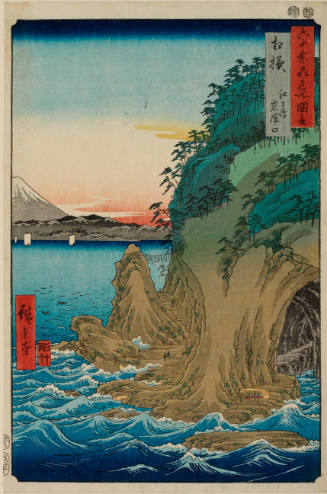
Sagami Province, Enoshima, The Entrance to the Caves, series Pictures of Famous Places in the Sixty Odd Provinces
Honolulu Museum of Art
Honolulu Museum of Art Collection

Tokugawa Ieyasu at the Entrance to a Palace, from the series A mirror of Famous Generals of Japan (Dai nippon meishō kagami)
Philadelphia Museum of Art
Philadelphia Museum of Art collection
Notice in three languages at entrance to the Wailing Wall in Jerusalem, Palestine - Photograph taken by M D ...
Alexander Turnbull Library
DigitalNZ New Zealand API
New Zealanders at the entrance of their dug-out on 5th Army Front, Italy, World War II - Photograph taken by...
Alexander Turnbull Library
DigitalNZ New Zealand API
Aerial view of a town set above the Sangro River, Italy - Photograph taken by George Kaye
Alexander Turnbull Library
DigitalNZ New Zealand API
NZ transport on the edge of the Sangro River in Italy, World War II - Photograph taken by George Kaye
Alexander Turnbull Library
DigitalNZ New Zealand API
matsubaranpu
British Museum
ARC Early Japanese Book Portal Database
Gōshū shūikizu : Roppyakumanbun no ichi
National Library of Australia
Trove: National Library of Australia
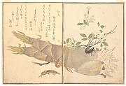
Mole Cricket (Kera); Earwig, (Hasami-mushi), from the Picture Book of Crawling Creatures (Ehon mushi erami)
Metropolitan Museum of Art
The Metropolitan Museum of Art Open Access CSV
「(東海道五十三次)鞠子」 「岡部へ三里」
Museum of Fine Arts, Boston
ARC Ukiyo-e Portal Database
![薩摩国[西海道図]](https://rmda.kulib.kyoto-u.ac.jp/iiif/RB00020071/RB00020071_00001_0.ptif/full/200,/0/default.jpg)
薩摩国[西海道図]
Kyoto University Library
IIIF Discovery in Japan

千吉兵衛書状
Sakai City Central Library
ADEAC: A System of Digitalization and Exhibition for Archive Collections
![[二十四孝] 「とうふじん」](http://www.arc.ritsumei.ac.jp/archive01/theater/th_image/PB/kokkai/rarebook.ndl.go.jp/pre/th_image/gazou/W0000008/w0000112/w0000006/w0000034.jpg)
[二十四孝] 「とうふじん」
National Diet Library, Japan
ARC Ukiyo-e Portal Database
[二十四孝] 「王祥」
National Diet Library, Japan
ARC Ukiyo-e Portal Database
[二十四孝] 「ごもう」
National Diet Library, Japan
ARC Ukiyo-e Portal Database
[二十四孝] 「くわつきよ」
National Diet Library, Japan
ARC Ukiyo-e Portal Database

板野郡大代村絵図
Tokushima Prefectural Library
ADEAC: A System of Digitalization and Exhibition for Archive Collections
![Carte de la Découverte faite en [1735] par les Hollandois, à la partie la plus orientale de l'Asie...](https://api.europeana.eu/api/v2/thumbnail-by-url.json?uri=http%3A%2F%2Fgallica.bnf.fr%2Fark%3A%2F12148%2Fbtv1b53032838p.thumbnail.jpg&type=IMAGE)
Carte de la Découverte faite en [1735] par les Hollandois, à la partie la plus orientale de l'Asie...
Bibliothèque nationale de France
Europeana API
新三十六歌仙図帖
Tokyo National Museum
ARC Ukiyo-e Portal Database

Carte generale d'une partie d'Afrique et d'Asie, depuis le Détroit de Gibraltar jusques aux Isles ...
Bibliothèque nationale de France
Europeana API

Tonamigunyamadagumisaimyoumuraryounaikenchiezu
Imizu City Shinminato Museum
ADEAC: A System of Digitalization and Exhibition for Archive Collections
Last Updated: 2020-04-17
Uploaded: 2021-09-21