
A Map of the East-Indies and the Adjacent Countries; with the Settlements, Factories and Territori...
- People
- Time
- Owner Organization

A Map of the East-Indies and the Adjacent Countries; with the Settlements, Factories and Territori...
Stanford University Libraries
Stanford Libraries SearchWorks

A Map of the East-Indies and the Adjacent Countries; with the Settlements, Factories and Territori...
Stanford University Libraries
Stanford Libraries SearchWorks

A Map of the East-Indies and the Adjacent Countries; with the Settlements, Factories and Territori...
Stanford University Libraries
Stanford Libraries SearchWorks
A map of the East-Indies and adjacent countries : with settlements, factories, and territories : explaining what belongs to England, Spain, France, Holland, Denmark, Portugal, etc. with many remarks not extant in any other map / by H. Moll, geog
National Library of Australia
Trove: National Library of Australia

A chart of the tradeing part of the East Indies and China, with the adjacent islands, from Surrat ...
Royal Museums Greenwich
Europeana API

A chart of the easternmost part of the East Indies with all the adjacent islands from Cape Comorin...
Royal Museums Greenwich
Europeana API

Map of the Island of Japan, Kurile &c. with the Adjacent Coasts of the Chinese Dominions and a Ske...
Stanford University Libraries
Stanford Libraries SearchWorks

Map of the Island of Japan, Kurile &c. with the Adjacent Coasts of the Chinese Dominions and a Ske...
Stanford University Libraries
Stanford Libraries SearchWorks

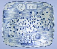
A map of the city of Nagasaki, and of the adjacent country; Sorts of money current in the Japanese Empire
General Research Division. The New York Public Library
DPLA API
A chart of the eastermost part of the East Indies with all the adjacent islands from Cape Comorin to Iapan / by Iohn Seller, Hydrographer to the King
National Library of Australia
Trove: National Library of Australia
This map shows, by the cross-lining, the Netherlands East Indies and also the island possessions of the U.S....
National Library of New Zealand
DigitalNZ New Zealand API
(Lower Sheet to) Map of the Island of Japan, Kurile &c. with the Adjacent Coasts of the Chinese Do...
Stanford University Libraries
Stanford Libraries SearchWorks
.jpg)
SOUTH-EAST ASIA AND EAST INDIES ARCHIPELAGO
New Zealand Electronic Text Collection
DigitalNZ New Zealand API

A Chart of the Eastermost part of the East Indies and China from Cape Comarin to Japan with the Ad...
Stanford University Libraries
Stanford Libraries SearchWorks

General map of China and adjacent regions, showing treaty ports and railways
Stanford University Libraries
Stanford Libraries SearchWorks

A chart of the eastermost part of the East Indies with all the adjacent islands from Cape Comorin to Iapan / by Iohn Seller, Hydrographer to the King ; F. Lamb Sculp
State Library of New South Wales
Trove: National Library of Australia
Stanford's map of China & Japan with the adjacent parts of the Russian Repubcs. India, Burma &c / Stanford's Geographical Establishment
National Library of Australia
Trove: National Library of Australia
Dish with a map of Japan and inscription
Rijksmuseum
Europeana API
A chart of ye eastermost part of the East Indies / by Iohn Seller
National Library of Australia
Trove: National Library of Australia
A view of-the Regent's residence at Medan, capital of the Netherlands East Indies island of Sumatra, The Jap...
National Library of New Zealand
DigitalNZ New Zealand API
![Japan and adjacent regions of Asia and the Pacific Ocean [cartographic material] / compiled and drawn in the...](https://collections.library.yale.edu/iiif/2/15510875/full/!200,200/0/default.jpg)
Japan and adjacent regions of Asia and the Pacific Ocean [cartographic material] / compiled and drawn in the...
Yale University Library
Yale University Library Digital Collections
![Japan and adjacent regions of Asia and the Pacific Ocean [cartographic material] / compiled and drawn in the...](https://collections.library.yale.edu/iiif/2/15509964/full/!200,200/0/default.jpg)
Japan and adjacent regions of Asia and the Pacific Ocean [cartographic material] / compiled and drawn in the...
Yale University Library
Yale University Library Digital Collections
![[Chinese Text with Image of a Map of the World]](https://api.europeana.eu/api/v2/thumbnail-by-url.json?uri=http%3A%2F%2Fmedia.iwm.org.uk%2Fiwm%2FmediaLib%2F191%2Fmedia-191923%2Flarge.jpg&type=IMAGE)
[Chinese Text with Image of a Map of the World]
Imperial War Museum
Europeana API
WAR IN THE EAST This map shows Malaya and the Philippine Islands and the principal scenes of the Japanese of...
National Library of New Zealand
DigitalNZ New Zealand API

To the Right Honorable William Lord Cowper Lord High Chancellor of Great Britain This Map of Asia ...
Stanford University Libraries
Stanford Libraries SearchWorks
A Map of the East-Indies and the Adjacent Countries; with the Settlements, Factories and Territori...
Stanford University Libraries
Stanford Libraries SearchWorks

L'Empire de la Chine d'après l'Atlas Chinois avec les Isles du Japon . .
Stanford University Libraries
Stanford Libraries SearchWorks

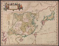
Tabula Tartariae et majoris partis regni Chinae / edita a F. de Wit ; Lhuilier fecit
Yale University Library
Yale University Library Digital Collections

To the Right Honorable William Lord Cowper Lord High Chancellor of Great Britain This Map of Asia ...
Stanford University Libraries
Stanford Libraries SearchWorks

Asiae Nova Delineatio . .
Stanford University Libraries
Stanford Libraries SearchWorks

Carte des Indes, de la Chine & des Iles de Sumatra, Java &c.
Stanford University Libraries
Stanford Libraries SearchWorks

Carte Des Indes et de la Chine Dressee sur plusieurs Relations particulieres Rectifees par quelque...
Stanford University Libraries
Stanford Libraries SearchWorks
A Map of the East-Indies and the Adjacent Countries; with the Settlements, Factories and Territori...
Stanford University Libraries
Stanford Libraries SearchWorks

Asiae Recentissima Delineatio Qua Status et Imperia Totius Orientis unacum Orientalibus Indiis…
Stanford University Libraries
Stanford Libraries SearchWorks

Magnae Tartariae Magni Mogolis Imperii Iaponiae et Chinae Nova Descriptio
Stanford University Libraries
Stanford Libraries SearchWorks
Imperii Sinarum nova descriptio
Yale University Library
Yale University Library Digital Collections

China, Contains 15 Subject Provinces, including the 2 Islands of Hainan Formosa and the Tributary ...
Stanford University Libraries
Stanford Libraries SearchWorks

A New Map of Great Tartary and China, with the adjoyning Parts of Asia, Taken from Mr. De Fer's Ma...
Stanford University Libraries
Stanford Libraries SearchWorks
Last Updated: 2020-04-17
Uploaded: 2021-09-21