
Pacific Front. 21. Amphibious Blitzkrieg
- Time
- Owner Organization
World War 2 New Zealand soldiers, during an amphibious training session, Pacific area
Alexander Turnbull Library
DigitalNZ New Zealand API
![Pacific war [electronic resource].](https://www.gumtree.com/static/1/resources/assets/rwd/images/orphans/a37b37d99e7cef805f354d47.noimage_thumbnail.png)
Pacific war [electronic resource].
Stanford University Libraries
Stanford Libraries SearchWorks
Pacific journal of mathematics for industry
Stanford University Libraries
Stanford Libraries SearchWorks
Pacific crucible : war at sea in the Pacific, 1941-1942 / Ian W. Toll
National Library of Australia
Trove: National Library of Australia
World War II troops, Pacific region
Alexander Turnbull Library
DigitalNZ New Zealand API
Atlas of isotope hydrology - Asia and the Pacific
National Library of Australia
Trove: National Library of Australia
North Pacific Ocean, Japan, Nampō-Shotō [electronic resource]
Stanford University Libraries
Stanford Libraries SearchWorks
World in action. Warclouds in the Pacific [electronic resource]
Stanford University Libraries
Stanford Libraries SearchWorks
The Japanese air-strip on Woleai Island, in the Pacific, ivas rendered useless by Pacific Fleet dive-bombers...
National Library of New Zealand
DigitalNZ New Zealand API
South Pacific - Fiji - Anti-tank wall, Suva Peninsula
Alexander Turnbull Library
DigitalNZ New Zealand API
World War II soldiers, Pacific region
Alexander Turnbull Library
DigitalNZ New Zealand API
.jpg)
The War against Japan: Allied Operations in the Pacific
New Zealand Electronic Text Collection
DigitalNZ New Zealand API
The mighty guns of an American battleship shelling the Japanese on Okinawa. In the foreground amphibious cra...
National Library of New Zealand
DigitalNZ New Zealand API
Theater of war. Episode 2, Under attack, Pearl Harbor [electronic resource] : the Pacific campaign
Stanford University Libraries
Stanford Libraries SearchWorks
World War II, Pacific region, after a rainstorm
Alexander Turnbull Library
DigitalNZ New Zealand API
NZ Engineers' experimental amphibious bren carrier taking ground coming ashore from the Nile at Maadi, Egypt...
Alexander Turnbull Library
DigitalNZ New Zealand API
Unidentified World War II soldiers, Pacific Area
Alexander Turnbull Library
DigitalNZ New Zealand API
Nara, series 1953 Calendar for the Pacific Transport Lines (1953年太平洋航運線カレンダー)
Honolulu Museum of Art
Honolulu Museum of Art Collection

JAPANESE SHIPS DESTROYED BY BOMBERS IN PACIFIC AND INDIAN OCEANS
Auckland Libraries
DigitalNZ New Zealand API
NZ Engineers' experimental amphibious bren carrier enters the water of the Nile at Maadi, Egypt - Photograph...
Alexander Turnbull Library
DigitalNZ New Zealand API
Inland Sea, series 1953 Calendar for the Pacific Transport Lines (1953年太平洋航運線カレンダー)
Honolulu Museum of Art
Honolulu Museum of Art Collection
Enoshima, series 1953 Calendar for the Pacific Transport Lines (1953年太平洋航運線カレンダー)
Honolulu Museum of Art
Honolulu Museum of Art Collection

Himeji Castle, series 1953 Calendar for the Pacific Transport Lines (1953年太平洋航運線カレンダー)
Honolulu Museum of Art
Honolulu Museum of Art Collection
Chūson Temple, series 1953 Calendar for the Pacific Transport Lines (1953年太平洋航運線カレンダー)
Honolulu Museum of Art
Honolulu Museum of Art Collection

Two Rabbits, from The Picture Book of Realistic Paintings of Hokusai (Hokusai shashin gafu)
Art Institute of Chicago
Art Institute of Chicago API

The world as known to the ancients
Yoshida-South Library, Kyoto University
IIIF Discovery in Japan

大日本帝國豫察東部地形圖
Department of Science, Kyoto University
IIIF Discovery in Japan

「曽我物語図会」 「五郎時致」「十郎祐成」
National Diet Library, Japan
ARC Ukiyo-e Portal Database
![America Bay [cartographic material]](https://stacks.stanford.edu/image/iiif/nj035cf2832%2Fnj035cf2832_00_0001/full/!200,200/0/default.jpg)
America Bay [cartographic material]
Stanford University Libraries
Stanford Libraries SearchWorks

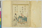
画本狂歌 山満多山 絵本
Keio University Media Center
Digital Collections of Keio University Libraries
Picture Book of the Souvenirs of Edo : [volume 04]
Metropolitan Museum of Art
The Metropolitan Museum of Art Digital Collection
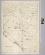
習志野演習場
Funabashi-shi Western Library
ADEAC: A System of Digitalization and Exhibition for Archive Collections

Hokusai soga (Object)
British Museum
British Museum Collection
![[Japan] (Published in Manila!)](https://stacks.stanford.edu/image/iiif/gv355sq3352%2F37869hs/full/!200,200/0/default.jpg)
[Japan] (Published in Manila!)
Stanford University Libraries
Stanford Libraries SearchWorks
jiraiyagouketsumonogatari
Art Research Center, Ritsumeikan University
ARC Early Japanese Book Portal Database
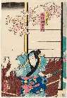
「下部鹿蔵 市村羽左エ門」
Museum of Fine Arts, Boston
ARC Ukiyo-e Portal Database
Last Updated: 2020-04-17
Uploaded: 2021-09-21