

Shinchiku shigaizu = : Map of Hsinchu city

Taichū shigaizu = Map of T'ai-chung city

Nagasaki shigai zenzu = The map of nagasaki city. Kiushiu. Japan

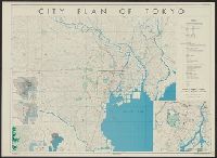
Map of Tokyo : city communications

Jitchi tōsoku Kōbe shigai zenzu = New map of Kobe

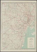
Central Tokyo : city map.
![Kaisei Atami Shigai Zenzu. [Revised Map of the Entire City of Atami]](https://collections.library.yale.edu/iiif/2/15510883/full/!200,200/0/default.jpg)
Kaisei Atami Shigai Zenzu. [Revised Map of the Entire City of Atami]
Akita City: Map of city. Report No. 14f(1)(f), USSBS Index Section 2

Guide to Tokyo City

Koubeshi zenzu = Map of Kobe

Koubeshi zenzu = Map of Kobe
City of Kobe 192A
Map- city of Tokyo. Report No. 12g(3), USSBS Index Section 2

A map of the city of Nagasaki, and of the adjacent country; Sorts of money current in the Japanese Empire
Map of city of Kyoto showing locations of sirens. Report No. 6d, USSBS Index Section 2
City plan of Yokohama
Japanese map of Nagasaki City giving brief history of city and other information. Report No. 3t(19), USSBS Index Section 2

City plan of Kōbe.
City plan of Tōkyō

Bird's Eye View of the City of Nebraska City. Otoe County Nebraska 1868

The City of Paris, France
Map of Kyoto City water system. Report No. 6h, USSBS Index Section 2

Hokutō onsen fukinzu = Map of Beitou hot springs and surrounding area
City map, central Tokyo. December 1946 / prepared under direction of the chief engineer, general headquarter...

(Composite of) Carta General Para Las Navegaciones a la India Oriental Por El Mar Del Sur Y el gra...

Ryukyu Islands roads, railroads and cables
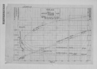
〔軍艦加古 馬力・速力関係曲線図〕

Koufushi zenzu

Japan, Manchuria, and adjacent regions
Chart of Japanese islands and surrounding seas

Karta Morskykh Otkrytii Rossiiskimi Moreplavatelimi na Tikhom ... [transliterated from the Cyrilli...

Peleng Strait to Tomori Gulf
Taichū shigaizu = Map of T'ai-chung city

Rongorapputō fukin

Koufushi zenzu

Eastern Portion of Flores to Lomblem

Ryōtō Kaiwan : Daitzu Shan to Fuchou Chao

Approach to West Coast of Gazelle Peninsula
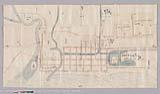
青森御町絵図
![[Palembang and Bangka Island, Indonesia] Het Eiland Banka. 1819 [and] De Rivier van Palembang. 1821](https://stacks.stanford.edu/image/iiif/vz793zp5933%2F36200/full/!200,200/0/default.jpg)
[Palembang and Bangka Island, Indonesia] Het Eiland Banka. 1819 [and] De Rivier van Palembang. 1821

Carta General Para Las Navegaciones a la India Oriental Por El Mar Del Sur Y el grande Oceano que ...
Carta General Para Las Navegaciones a la India Oriental Por El Mar Del Sur Y el grande Oceano que ...

Manshū Gomanbun no ichi Haisen Kokusan fukin
![[Russian Map of Northeastern Asia, Japan, Korea, China, Alaska, etc.] ( Summary map of hydrographi...](https://stacks.stanford.edu/image/iiif/pj697kr2558%2F35405/full/!200,200/0/default.jpg)
[Russian Map of Northeastern Asia, Japan, Korea, China, Alaska, etc.] ( Summary map of hydrographi...

Durville Island and Approaches
Nitshikan kōro ryakuzu

Koufushi zenzu
![Jūmanbunnoichi ponapetō fukin [cartographic material]](https://stacks.stanford.edu/image/iiif/gy526zz1113%2Fgy526zz1113_00_0001/full/!200,200/0/default.jpg)
Jūmanbunnoichi ponapetō fukin [cartographic material]
Last Updated: 2020-04-17
Uploaded: 2021-09-21