
![Kantō area [cartographic material] : highways and waterways](https://stacks.stanford.edu/image/iiif/gd204cf5107%2Fgd204cf5107_00_0001/full/!200,200/0/default.jpg)
Kantō area [cartographic material] : highways and waterways
Stanford University Libraries
Stanford Libraries SearchWorks
Frontispiece (Kantō), series Striking Views of Mount Fuji
Honolulu Museum of Art
Honolulu Museum of Art Collection

Japan Series: Ginza Area, Tokyo
Museum of New Zealand Te Papa Tongarewa
DigitalNZ New Zealand API

Map of Marunouchi area
Stanford University Libraries
Stanford Libraries SearchWorks

Japan area: showing area covered by studies
Monash University Library
Trove: National Library of Australia
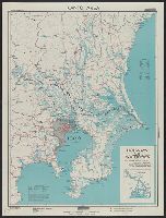
Kantō area : highways and waterways
Yale University Library
Yale University Library Digital Collections
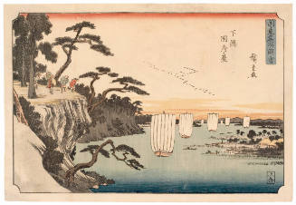
Kōnodai in Shimōsa Province (Shimōsa Kōnodai), series Pictures of Famous Views of Kantō
Honolulu Museum of Art
Honolulu Museum of Art Collection
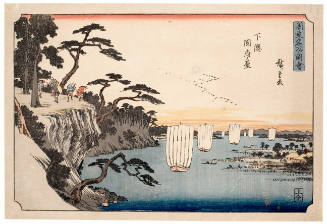
Kōnodai in Shimōsa Province (Shimōsa Kōnodai), series Pictures of Famous Views of Kantō
Honolulu Museum of Art
Honolulu Museum of Art Collection
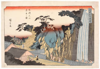
The Rōben Waterfall at ōyama in Sagami Province, series Pictures of Famous Views of Kantō
Honolulu Museum of Art
Honolulu Museum of Art Collection
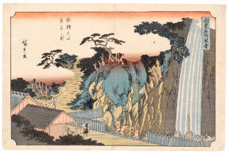
The Rōben Waterfall at ōyama in Sagami Province, series Pictures of Famous Views of Kantō
Honolulu Museum of Art
Honolulu Museum of Art Collection
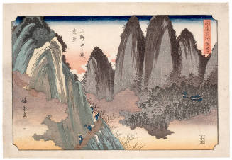
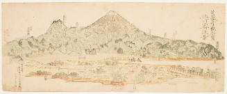
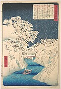
Distant View of Mt. Nakano in Kōzuke Province, series Pictures of Famous Views of Kantō
Honolulu Museum of Art
Honolulu Museum of Art Collection
![[Tokyo waxes jubilant over capture of Wuhan Area.]](https://api.europeana.eu/api/v2/thumbnail-by-url.json?uri=http%3A%2F%2Fwww.beeldbankwo2.nl%2Fcgi-bin%2Ffrsiserver.dll%2Fthumbnail%2F49387-thumb.jpg%3Ffrskey%3D49387&type=IMAGE)
[Tokyo waxes jubilant over capture of Wuhan Area.]
NIOD Institute for War, Holocaust and Genocide Studies
Europeana API

Osaka-Kobe area: Nishinomiya: Hyogo Prefecture, Honshu, Japan
Monash University Library
Trove: National Library of Australia
Tohoku Area
NDL Digital Collections
NDL Digital Collections
Kimki Area
NDL Digital Collections
NDL Digital Collections
Kyushu Area
NDL Digital Collections
NDL Digital Collections
Kanto Area
NDL Digital Collections
NDL Digital Collections
Hokkaido Area
NDL Digital Collections
NDL Digital Collections
A view of the area from below Hangmans Hill, Cassino
Alexander Turnbull Library
DigitalNZ New Zealand API
General view of the packing area of the Hove Dump, Cassino area, Italy - Photograph taken by George Bull
Alexander Turnbull Library
DigitalNZ New Zealand API
![Sketch map of Sendai area [cartographic material] : Honshu-Japan](https://stacks.stanford.edu/image/iiif/vt543dv4637%2Fvt543dv4637_00_0001/full/!200,200/0/default.jpg)
Sketch map of Sendai area [cartographic material] : Honshu-Japan
Stanford University Libraries
Stanford Libraries SearchWorks

Osaka-Kobe area: Osaka North: Osaka Prefecture, Honshu, Japan
Monash University Library
Trove: National Library of Australia

CAPITAL OF DEFEATED JAPAN: TOKYO AREA CHOSEN FOR FIRST ALLIED LANDINGS
Auckland Libraries
DigitalNZ New Zealand API

Osaka-Kobe area: Kobe Proper: Hyogo Prefecture, Honshu, Japan
Monash University Library
Trove: National Library of Australia
Kantō area [cartographic material] : highways and waterways
Stanford University Libraries
Stanford Libraries SearchWorks
「末広五十三次」 「舞阪」
Metropolitan Museum of Art
ARC Ukiyo-e Portal Database
Woodblock print
Metropolitan Museum of Art
The Metropolitan Museum of Art Open Access CSV

Australia - West Coast. Shark Bay
Stanford University Libraries
Stanford Libraries SearchWorks

China. (with) Islands of Japan. By Keith Johnston, F.R.S.E. Keith Johnston's General Atlas. Engrav...
Stanford University Libraries
Stanford Libraries SearchWorks

China and Japan
Stanford University Libraries
Stanford Libraries SearchWorks

Das Chinesische Reich Mit Seinen Schutzstaaten, Nebst dem Japanischen Inselreiche Gotha, bei Justu...
Stanford University Libraries
Stanford Libraries SearchWorks

China, Contains 15 Subject Provinces, including the 2 Islands of Hainan Formosa and the Tributary ...
Stanford University Libraries
Stanford Libraries SearchWorks

La Partie Orientale de l'Asie ou se trouvent Le Grand Empire des Tartares Chinois et celuy du Japon
Stanford University Libraries
Stanford Libraries SearchWorks

Ost-Indien
Stanford University Libraries
Stanford Libraries SearchWorks
Metropolitan Museum of Art
The Metropolitan Museum of Art Open Access CSV

Sharpe's Corresponding Maps. South Eastern Asia. Birmah - China - Japan London - Published by Chap...
Stanford University Libraries
Stanford Libraries SearchWorks

Imperii Russici et Tatariae Universae tam majoris et Asiaticae quam minoris et Europae Tabula . .....
Stanford University Libraries
Stanford Libraries SearchWorks

No. 69. China und Japan
Stanford University Libraries
Stanford Libraries SearchWorks

L'empire du Japon divisé en sept principales parties, et subdivisé en soixante et six royaumes / p...
Bibliothèque nationale de France
Europeana API

China and Japan. Drawn & engraved by J. Dower. London, Published by Henry Teesdale & Co. (to accom...
Stanford University Libraries
Stanford Libraries SearchWorks

Nr. 56. Nord-& Mittel-Asien. ... von H. Hebenicht
Stanford University Libraries
Stanford Libraries SearchWorks

「宮本無三四」
National Diet Library, Japan
ARC Ukiyo-e Portal Database

Das Chinesische Reich Mit Seinen Schutzstaaten Nebst Dem Japanishcen Inselreiche. . . .1833
Stanford University Libraries
Stanford Libraries SearchWorks
![Chinkaiwan yōsai Masan Kinbō [cartographic material]](https://stacks.stanford.edu/image/iiif/tb303fm7493%2Ftb303fm7493_00_0001/full/!200,200/0/default.jpg)
Chinkaiwan yōsai Masan Kinbō [cartographic material]
Stanford University Libraries
Stanford Libraries SearchWorks
![A New & Accurate Map of Asia . . . [Shows Mythical De Gama's Land!]](https://stacks.stanford.edu/image/iiif/gy686vg9722%2F30577/full/!200,200/0/default.jpg)
A New & Accurate Map of Asia . . . [Shows Mythical De Gama's Land!]
Stanford University Libraries
Stanford Libraries SearchWorks

Tartarie Chinoise, Roy, De Coree et Isles Du Japon
Stanford University Libraries
Stanford Libraries SearchWorks

Karte des Ostasiastichen kriegsschauplatzes / von Gustav Richter
Bibliothèque nationale de France
Europeana API

Tokyo kara higaeri 1-2 - haka ryoko chokanzu. Tokyo Noriai Jidosha kabushiki kaisha Yuranka. Atora...
Stanford University Libraries
Stanford Libraries SearchWorks
Last Updated: 2020-04-17
Uploaded: 2021-09-21