

Town plan of Toyohashi
Stanford University Libraries
Stanford Libraries SearchWorks

Japan : Karafuto, town plan of Ochiai
Stanford University Libraries
Stanford Libraries SearchWorks
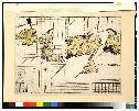
![Town plan of Sendai [cartographic material]](https://stacks.stanford.edu/image/iiif/fv573yp8495%2Ffv573yp8495_00_0001/full/!200,200/0/default.jpg)
Town plan of Sendai [cartographic material]
Stanford University Libraries
Stanford Libraries SearchWorks

Japan : Karafuto : town plan of Ōtomari
Stanford University Libraries
Stanford Libraries SearchWorks

Town plan of Wakayama
Monash University Library
Trove: National Library of Australia

Town plan of Otomari : Japan: Karafuto
Monash University Library
Trove: National Library of Australia

Town plan of Toyohara : Japan: Karafuto
Monash University Library
Trove: National Library of Australia
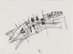
Town Plan Project, Kobe, Japan, Site plan
Museum of Modern Art, New York
The Museum of Modern Art (MoMA) Collection
USSR 6200: Town Plan Information
NDL Digital Collections
NDL Digital Collections

Plan of thermo-baths ; Kokura town plan; devices used for the criminals' executions; a large bell; a shuit o...
General Research Division. The New York Public Library
DPLA API
Town (Machi)
Harvard Art Museums
Harvard Art Museums API

Town of Odowara
The Miriam and Ira D. Wallach Division of Art, Prints and Photographs. The New York Public Library
DPLA API

Plan of Yokohama
Stanford University Libraries
Stanford Libraries SearchWorks

West Town of Nikko
Worcester Art Museum
Worcester Art Museum Collection

?Murakumo” Lowerdeck Plan and Plan of Hold
東京大学柏図書館
UTokyo Academic Archives Portal
City plan of Yokohama
National Library of Australia
Trove: National Library of Australia

City plan of Kōbe.
Stanford University Libraries
Stanford Libraries SearchWorks

Reconstruction plan of Yokohama
Stanford University Libraries
Stanford Libraries SearchWorks
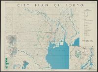
City plan of Tōkyō
Yale University Library
Yale University Library Digital Collections
Ruins of the Italian town of Cassino
Alexander Turnbull Library
DigitalNZ New Zealand API

Capture of a Strange Town
Art Institute of Chicago
Art Institute of Chicago API
Recently: the town' of Tientsin was inundated when waters of the Pei River entered the town and transformed ...
National Library of New Zealand
DigitalNZ New Zealand API

The Outskirts of a Flemish Town
Freer and Sackler
DPLA API
The old town of Matsue
NDL Digital Collections
NDL Digital Collections
Town plan of Sendai [cartographic material]
Stanford University Libraries
Stanford Libraries SearchWorks

Central Japan (central and northern Honshū) distribution of population
Stanford University Libraries
Stanford Libraries SearchWorks
![Nagoya [cartographic material] : municipal water supply, distribution](https://stacks.stanford.edu/image/iiif/cx861js2541%2Fcx861js2541_00_0001/full/!200,200/0/default.jpg)
Nagoya [cartographic material] : municipal water supply, distribution
Stanford University Libraries
Stanford Libraries SearchWorks

The Japanese petroleum industry (map no. two)
Stanford University Libraries
Stanford Libraries SearchWorks

Shinchiku shigaizu = : Map of Hsinchu city
Stanford University Libraries
Stanford Libraries SearchWorks
![Sea fisheries of eastern Asia [cartographic material]](https://stacks.stanford.edu/image/iiif/mr870gt3467%2Fmr870gt3467_00_0001/full/!200,200/0/default.jpg)
Sea fisheries of eastern Asia [cartographic material]
Stanford University Libraries
Stanford Libraries SearchWorks

千葉県北総東葛飾郡沿浦之地図
Funabashi-shi Western Library
ADEAC: A System of Digitalization and Exhibition for Archive Collections

Agriculture in Japan
Stanford University Libraries
Stanford Libraries SearchWorks

Central Japan (central and northern Honshū) water supply
Stanford University Libraries
Stanford Libraries SearchWorks
City plan of Kōbe.
Stanford University Libraries
Stanford Libraries SearchWorks
![Tōkyō, Ōmori-ku, guide to postal districts [cartographic material] = 大森區詳細圖](https://collections.library.yale.edu/iiif/2/15511728/full/!200,200/0/default.jpg)
Tōkyō, Ōmori-ku, guide to postal districts [cartographic material] = 大森區詳細圖
Yale University Library
Yale University Library Digital Collections

Ube, Yamaguchi Prefecture, Honshū, Japan
Stanford University Libraries
Stanford Libraries SearchWorks

Hitoyoshi, Japan, Kumamoto Ken, Kyushu
Stanford University Libraries
Stanford Libraries SearchWorks

Kajiki, Japan, Kagoshima-ken, Kyushu
Stanford University Libraries
Stanford Libraries SearchWorks

Ichimanbun no ichi Toyohara kinbō
Stanford University Libraries
Stanford Libraries SearchWorks

Eastern Archipelago : Celebes - East Coast. Tg. Losoni to Northern Entrance to Buton Str.
Stanford University Libraries
Stanford Libraries SearchWorks

Hiratsuka
Stanford University Libraries
Stanford Libraries SearchWorks

都市計畫基本圖. : 7 松ヶ崎
Yoshida-South Library, Kyoto University
IIIF Discovery in Japan
![Yokohama : [base map showing political divisions]](https://stacks.stanford.edu/image/iiif/hg765ms3579%2Fhg765ms3579_00_0001/full/!200,200/0/default.jpg)
Yokohama : [base map showing political divisions]
Stanford University Libraries
Stanford Libraries SearchWorks
大江山酒呑童子図
Tokyo National Museum
ARC Ukiyo-e Portal Database

Southwest Japan (Kyūshū, Shikoku, and southwest Honshū), railroads and railroad facilities [cartog...
Stanford University Libraries
Stanford Libraries SearchWorks

Manshū Gomanbun no ichi Haisen Kokusan fukin
Stanford University Libraries
Stanford Libraries SearchWorks
![Japan [cartographic material] : ports of greatest shipping activity](https://stacks.stanford.edu/image/iiif/yg817zs3009%2Fyg817zs3009_00_0001/full/!200,200/0/default.jpg)
Japan [cartographic material] : ports of greatest shipping activity
Stanford University Libraries
Stanford Libraries SearchWorks

Celebes - West Coast : Cape William to Tandyung Karang
Stanford University Libraries
Stanford Libraries SearchWorks
Last Updated: 2020-04-17
Uploaded: 2021-09-21