

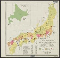
Population densities in Japan : Densities by prefectures and provinces
Stanford University Libraries
Stanford Libraries SearchWorks

Japan : population densities by prefectures and provinces
Stanford University Libraries
Stanford Libraries SearchWorks
Japan: population densities by prefectures and province
Yale University Library
Yale University Library Digital Collections

Japan, population changes 1935-1940
Yale University Library
Yale University Library Digital Collections

Kobe, density of population : 1940
Stanford University Libraries
Stanford Libraries SearchWorks

Density of population in greater Tokyo - census of 1926
Boston Public Library
DPLA API
Proportion of total population born in Japan - By region in New Zealand, 2013 Census, % of people in each re...
http://dbpedia.org/resource/Figshare
DigitalNZ New Zealand API

Japan, population, showing the relative amount of population from light, lowest, to dark, highest
The Miriam and Ira D. Wallach Division of Art, Prints and Photographs. The New York Public Library
DPLA API

Central Japan (central and northern Honshū) distribution of population
Stanford University Libraries
Stanford Libraries SearchWorks
Annual Change in Population of Japan 1920-1947
NDL Digital Collections
NDL Digital Collections

The Japanese journal of population
Stanford University Libraries
Stanford Libraries SearchWorks
![[Japanese population increase.]](https://api.europeana.eu/api/v2/thumbnail-by-url.json?uri=http%3A%2F%2Fwww.beeldbankwo2.nl%2Fcgi-bin%2Ffrsiserver.dll%2Fthumbnail%2F49360-thumb.jpg%3Ffrskey%3D49360&type=IMAGE)
[Japanese population increase.]
NIOD Institute for War, Holocaust and Genocide Studies
Europeana API
Hospital beds [electronic resource]: Density per 1 000 population
Stanford University Libraries
Stanford Libraries SearchWorks
Population ecology
Stanford University Libraries
Stanford Libraries SearchWorks
Practising nurses [electronic resource]: Density per 1 000 population
Stanford University Libraries
Stanford Libraries SearchWorks

New Zealand’s Japanese population, 1981–2001
New Zealand Ministry for Culture and Heritage
DigitalNZ New Zealand API
Practising physicians (doctors) [electronic resource]: Density per 1 000 population
Stanford University Libraries
Stanford Libraries SearchWorks

Stanford in Japan
Stanford University Libraries
Stanford Libraries SearchWorks

Stanford in Japan
Stanford University Libraries
Stanford Libraries SearchWorks

Stanford in Japan
Stanford University Libraries
Stanford Libraries SearchWorks

Stanford in Japan
Stanford University Libraries
Stanford Libraries SearchWorks

Stanford in Japan
Stanford University Libraries
Stanford Libraries SearchWorks

Stanford in Japan
Stanford University Libraries
Stanford Libraries SearchWorks

Stanford in Japan
Stanford University Libraries
Stanford Libraries SearchWorks

Japan, Manchuria, and Korea : principal languages needed by interpreters in these areas
Stanford University Libraries
Stanford Libraries SearchWorks

Niman-gosenbun no ichi zu Renzanwan kinbō
Stanford University Libraries
Stanford Libraries SearchWorks
![Tsuruga-shi Kōkū shashin sokuryōzu [cartographic material]](https://stacks.stanford.edu/image/iiif/yn152cf5419%2Fyn152cf5419_00_0001/full/!200,200/0/default.jpg)
Tsuruga-shi Kōkū shashin sokuryōzu [cartographic material]
Stanford University Libraries
Stanford Libraries SearchWorks
![Kantō area [cartographic material] : highways and waterways](https://stacks.stanford.edu/image/iiif/gd204cf5107%2Fgd204cf5107_00_0001/full/!200,200/0/default.jpg)
Kantō area [cartographic material] : highways and waterways
Stanford University Libraries
Stanford Libraries SearchWorks
![Tokyo : [base map showing political divisions]](https://stacks.stanford.edu/image/iiif/jw443fg4075%2Fjw443fg4075_00_0001/full/!200,200/0/default.jpg)
Tokyo : [base map showing political divisions]
Stanford University Libraries
Stanford Libraries SearchWorks

Papua Gomanbunnoichi zu
Stanford University Libraries
Stanford Libraries SearchWorks

Nyūjōjiatō fukin sozu
Stanford University Libraries
Stanford Libraries SearchWorks

Kūchū shashin yōzu Sanman Gosen bun no ichi Bisumaruku Guntō Tsurubu - Busshingu Misaki kan
Stanford University Libraries
Stanford Libraries SearchWorks

Plans in south eastern part of New Guinea
Stanford University Libraries
Stanford Libraries SearchWorks

Southern Okinawa
Stanford University Libraries
Stanford Libraries SearchWorks

Ichimanbun no ichi chikeizu Yokohama kinbō
Stanford University Libraries
Stanford Libraries SearchWorks

Japanese living in the far east outside Japan Proper
Stanford University Libraries
Stanford Libraries SearchWorks

Carte De L'Oceanie Contenant L'Australe, La Polynesie et Les Iles Asiatique [Australia called Nota...
Stanford University Libraries
Stanford Libraries SearchWorks
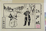
Edojou
Shochiku Otani Library
ARC Banzuke (Playbills) Portal Database

Kyushu
Stanford University Libraries
Stanford Libraries SearchWorks

Ost-Indien
Stanford University Libraries
Stanford Libraries SearchWorks

The Japanese petroleum industry (map no. two)
Stanford University Libraries
Stanford Libraries SearchWorks

Tartarie Chinoise, Roy, De Coree et Isles Du Japon
Stanford University Libraries
Stanford Libraries SearchWorks

「東寺太師堂」 「都名勝 三拾景 初編」
Art Research Center, Ritsumeikan University
ARC Ukiyo-e Portal Database
Central Japan (central and northern Honshū) distribution of population
Stanford University Libraries
Stanford Libraries SearchWorks

Rand, McNally & Company's indexed atlas of the world map of Japan Copyright 1892, by Rand, McNally...
Stanford University Libraries
Stanford Libraries SearchWorks

Ost-Indien
Stanford University Libraries
Stanford Libraries SearchWorks

Chuushinguraanasagashiyanagidaru
Ako City Local History Compilation Department
ARC Ukiyo-e Portal Database

Hokutō onsen fukinzu = Map of Beitou hot springs and surrounding area
Stanford University Libraries
Stanford Libraries SearchWorks
Last Updated: 2020-04-17
Uploaded: 2021-09-21