

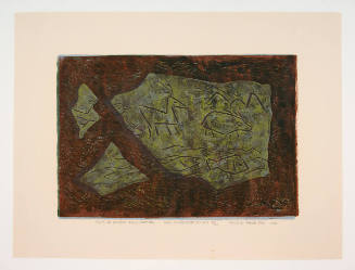
New Guinea - South Coast. Freshwater Bay to C. Blackwood
Stanford University Libraries
Stanford Libraries SearchWorks
View of Hiroshima from Town Hall building showing damage to museum building
Alexander Turnbull Library
DigitalNZ New Zealand API

Kioto Town from Maruyama
The Miriam and Ira D. Wallach Division of Art, Prints and Photographs. The New York Public Library
DPLA API

Kioto Town from Maruyama
The Miriam and Ira D. Wallach Division of Art, Prints and Photographs. The New York Public Library
DPLA API
Damage to town of Larissa, Greece, World War II
Alexander Turnbull Library
DigitalNZ New Zealand API

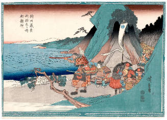
Soga Garo Galloping into Town Bareback to Rescue His Brother from Imagined Danger
Philadelphia Museum of Art
Philadelphia Museum of Art collection
Entrance to Suda Bay, Crete, showing fort in foreground
Alexander Turnbull Library
DigitalNZ New Zealand API
View over town to Lake Tiberias, also known as the Sea of Galilee, Palestine
Alexander Turnbull Library
DigitalNZ New Zealand API

Second fleet of Japanese warships and transports on their way from Talienwan to Yung-Ching bay
Rijksmuseum
Europeana API

View of Hong-Kong From East Point
Stanford University Libraries
Stanford Libraries SearchWorks

Mt. Fuji From Suruga Bay, Sunset
Freer and Sackler
DPLA API

Harbour bridge under construction, viewed from Birkenhead Point
Auckland Libraries
DigitalNZ New Zealand API

View of Shinagawa Bay from Gotenyama
Philadelphia Museum of Art
Philadelphia Museum of Art collection

Ship on Waitemata Harbour viewed through pines, Northcote Point
Auckland Libraries
DigitalNZ New Zealand API
From Ancient Wall (Tori to Kemono to Uo)
Honolulu Museum of Art
Honolulu Museum of Art Collection

Japan-Yezo Id., e. coast, Akishi Bay republished from the Brt. Admty. chart no. 992, corrected to 1873
Boston Public Library
DPLA API
Nitta Yoshisada Prays to the Dragon God at Inamura Point in 1333 ), series Scenes from Chinese and Japanese History
Honolulu Museum of Art
Honolulu Museum of Art Collection

Daikoku to karako
Library of Congress
Digital Collections, Library of Congress
"From East to West"
Digitales Kunst- und Kulturarchiv Düsseldorf
Europeana API
Signpost on the road to Enfidaville while the town was still occupied by German infantry in World War II - P...
Alexander Turnbull Library
DigitalNZ New Zealand API

Yui town, Suruga, from the series Selection of views of the Tokaido
Freer and Sackler
DPLA API
World War, 1939-1945. Norfolk Island. Ball Bay
Alexander Turnbull Library
DigitalNZ New Zealand API
World War, 1939-1945. Norfolk Island. Ball Bay
Alexander Turnbull Library
DigitalNZ New Zealand API

Genes to cells
Stanford University Libraries
Stanford Libraries SearchWorks

Durville Island and Approaches
Stanford University Libraries
Stanford Libraries SearchWorks

Ryōtō Kaiwan : Daitzu Shan to Fuchou Chao
Stanford University Libraries
Stanford Libraries SearchWorks

China - east coast : Hangchow Wan - southeast portion : including the approaches to the Yung Kiang
Stanford University Libraries
Stanford Libraries SearchWorks

Rice areas in Japan
Stanford University Libraries
Stanford Libraries SearchWorks

Skizze des weges von Tokio nach Yumotto (Nikko Berge) nach eigenen Aufzeichnungen / von E. Knippin...
Bibliothèque nationale de France
Europeana API

Saipantō
Stanford University Libraries
Stanford Libraries SearchWorks

Japan, acreage of rice by prefectures, 1939. Japan, acreage of wheat by prefectures, 1939
Stanford University Libraries
Stanford Libraries SearchWorks
![[Spanish Chart of the Philippines, China, Japan, Korea, Kamtchatka, Western Pacific]](https://stacks.stanford.edu/image/iiif/nk348cb2252%2F42187sh/full/!200,200/0/default.jpg)
[Spanish Chart of the Philippines, China, Japan, Korea, Kamtchatka, Western Pacific]
Stanford University Libraries
Stanford Libraries SearchWorks

Partie Septentrionale De L'Ocean Pacifique ou L'on Marque Les Decouvertes Et Les Routes De Mrs. De...
Stanford University Libraries
Stanford Libraries SearchWorks
![Japan [cartographic material] : Kyushu north coast](https://stacks.stanford.edu/image/iiif/gy001xy3796%2Fgy001xy3796_00_0001/full/!200,200/0/default.jpg)
Japan [cartographic material] : Kyushu north coast
Stanford University Libraries
Stanford Libraries SearchWorks

Plans of Anchorages in Witu Islands
Stanford University Libraries
Stanford Libraries SearchWorks

Japan, Hokushu _ West Coast. Iwanai Byochi and Approaches
Stanford University Libraries
Stanford Libraries SearchWorks

South Pacific Ocean : New Hebrides Is. North Coast of Aneityum Island showing Port Patrick, Ijipth...
Stanford University Libraries
Stanford Libraries SearchWorks

Isola del Giapone e penisola de Corea. Dedicata al Molto Revdo. Pre. Fontaine della compagnia de G...
Stanford University Libraries
Stanford Libraries SearchWorks

Carte des Isles du Japon et la Presqu Isle de Coree Avec les Costes de la Chine. Depuis Pekin Jusqu'a Canton...
Yale University Library
Yale University Library Digital Collections

Japan: Topography and industrial areas
Stanford University Libraries
Stanford Libraries SearchWorks
Last Updated: 2020-04-17
Uploaded: 2021-09-21