

Eastern Portion of Flores to Lomblem
Stanford University Libraries
Stanford Libraries SearchWorks

Straits between Sumbawa, Flores and Sumba
Stanford University Libraries
Stanford Libraries SearchWorks

Eastern Archipelago. Flores and Timor Seas
Stanford University Libraries
Stanford Libraries SearchWorks

Portrait of a Western Man
Minneapolis Institute of Arts
Minneapolis Institute of Art API
Western Desert dugout of NZ 2 ASC officers
Alexander Turnbull Library
DigitalNZ New Zealand API

Eastern Archipelago : Flores Sea. Tana Jampea and Adjacent Islands
Stanford University Libraries
Stanford Libraries SearchWorks
Mail delivery, Western Desert
Alexander Turnbull Library
DigitalNZ New Zealand API
Army cooks, western desert
Alexander Turnbull Library
DigitalNZ New Zealand API
NZ engineers in the Western Desert
Alexander Turnbull Library
DigitalNZ New Zealand API
NZ engineers in the Western Desert
Alexander Turnbull Library
DigitalNZ New Zealand API
Machine gun position, Western Desert
Alexander Turnbull Library
DigitalNZ New Zealand API
Soldiers of the Maori Battalion training in the Western Desert, Egypt
Alexander Turnbull Library
DigitalNZ New Zealand API
Dug in tent of mobile surgical unit in the Western Desert
Alexander Turnbull Library
DigitalNZ New Zealand API
Neil Grace of the New Zealand Railway Operating Unit guides shunting of train, Western Desert
Alexander Turnbull Library
DigitalNZ New Zealand API
"Garden of Nishihonganji (a great buddhist temple) in Saiko, western capital."
Royal Library of the Netherlands
Europeana API
England, Egypt, Gallipoli and Western Front
https://www.armymuseum.co.nz/
DigitalNZ New Zealand API
Christmas dinner for NZ Division in the Western Desert
Alexander Turnbull Library
DigitalNZ New Zealand API
Group of New Zealanders outside their bivvy in the Western Desert, Egypt
Alexander Turnbull Library
DigitalNZ New Zealand API
Bofors anti aircraft gun, Western Desert
Alexander Turnbull Library
DigitalNZ New Zealand API
NZ machine gun post, Western Desert
Alexander Turnbull Library
DigitalNZ New Zealand API

Western Hamlet, Horyu Temple (Horyuji nishi sato)
Art Institute of Chicago
Art Institute of Chicago API
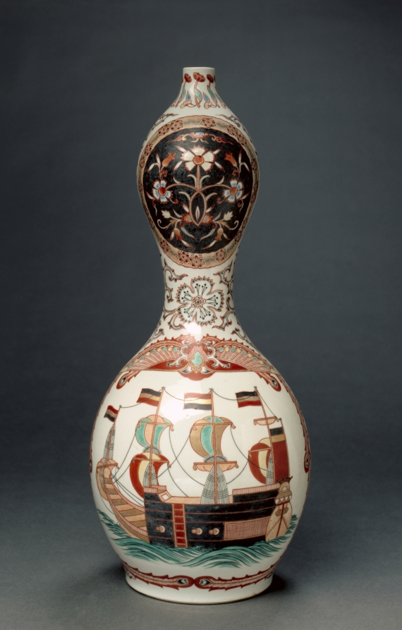
Bottle with Western Ships
Cleveland Museum of Art
The Cleveland Museum of Art Open Access API
NZEF troops training in the Western Desert
Alexander Turnbull Library
DigitalNZ New Zealand API
Officers mess cookhouse, Divisional HQ, Western Desert
Alexander Turnbull Library
DigitalNZ New Zealand API
Eastern Portion of Flores to Lomblem
Stanford University Libraries
Stanford Libraries SearchWorks

Approach to West Coast of Gazelle Peninsula
Stanford University Libraries
Stanford Libraries SearchWorks

New Guinea - South Coast. Freshwater Bay to C. Blackwood
Stanford University Libraries
Stanford Libraries SearchWorks

Carte Des Cotes De L'Amerique Et De L'Asie depuis la Californie jusqu'a Macao . . . 1786 et 1787 ....
Stanford University Libraries
Stanford Libraries SearchWorks

Central Portion of Sumbawa with Pulo Tenga Islands
Stanford University Libraries
Stanford Libraries SearchWorks

Togian Isles to Peleng Strait
Stanford University Libraries
Stanford Libraries SearchWorks
Straits between Sumbawa, Flores and Sumba
Stanford University Libraries
Stanford Libraries SearchWorks

North Pacific Ocean : Eastern Part of Hawaiin Islands
Stanford University Libraries
Stanford Libraries SearchWorks

Japan : political divisions / Board of Economic Warfare ; drawn in R and A, OSS
Yale University Library
Yale University Library Digital Collections

Chart of Discoveries made in 1787, in the Seas of China and Tartary, by the Boussole and Astrolabe...
Stanford University Libraries
Stanford Libraries SearchWorks
![Orientation, Philippines to Japan [cartographic material]](https://stacks.stanford.edu/image/iiif/nh916xd2027%2Fnh916xd2027_00_0001/full/!200,200/0/default.jpg)
Orientation, Philippines to Japan [cartographic material]
Stanford University Libraries
Stanford Libraries SearchWorks

Karta Morskykh Otkrytii Rossiiskimi Moreplavatelimi na Tikhom ... [transliterated from the Cyrilli...
Stanford University Libraries
Stanford Libraries SearchWorks

Japan, Manchuria, and adjacent regions
Stanford University Libraries
Stanford Libraries SearchWorks
Last Updated: 2020-04-17
Uploaded: 2021-09-21