
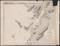
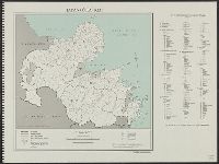
Japan, Hokkaido (Yezo) West Coast. Furubira Wan to Aikappu Misaki
- Time
- Owner Organization

Japan Series: Hokkaido - Furubira
![Karia [Kariya], west coast of Japan](https://api.europeana.eu/api/v2/thumbnail-by-url.json?uri=http%3A%2F%2Fcollections.rmg.co.uk%2FmediaLib%2F537%2Fmedia-537366%2Flarge.jpg&type=IMAGE)
Karia [Kariya], west coast of Japan

Japan, Hokushu _ West Coast. Iwanai Byochi and Approaches

Approach to West Coast of Gazelle Peninsula

Japan, Hokushu - South Coast. Uchiura Wan or Iburi Wan (Volcano Bay)

Celebes - West Coast : Cape William to Tandyung Karang

Ise Bay - North :

Furubira fish market, Shakotan Peninsula, Hokkaido, Japan. Taken for a series on Japan for ‘Life’
![Trip to Japan: Flight over North Pole; Hokkaido]](https://api.europeana.eu/api/v2/thumbnail-by-url.json?uri=http%3A%2F%2Fimages3.noterik.com%2Fdomain%2Feuscreenxl%2Fuser%2Feu_sase%2Fvideo%2FEUS_EB3AA13E888726A1A879A87CE9E9FF5E%2Fimage.jpg&type=VIDEO)
Trip to Japan: Flight over North Pole; Hokkaido]

JAPANESE RAID TOWNS ON THE NORTH-WEST COAST OF AUSTRALIA

Furubira fish market, Shakotan Peninsula, Hokkaido. Taken for a series on Japan for 'Life'

Japan-Yezo Id., e. coast, Akishi Bay republished from the Brt. Admty. chart no. 992, corrected to 1873
Japan Kiusiu Island, West Coast. Nagasaki Harbour, 1861 / engraved by Davies & Powell

West Coast of Korea. Approaches to Séoul : with Sir James Hall Group and Ta-Tong River

Amazing invasion map : Jap plan to seize the West Coast : Pictorial review. Seattle Post - Intelli...

(Map of Hokkaido, Japan). (to accompany) Shomitsu Nippon chizu. (Atlas of Japan) Nippon Shoin. (To...

(Hokkaido 1). (to accompany) Shomitsu Nippon chizu. (Atlas of Japan). Nippon Shoin (Tokyo, 1956)

(Hokkaido 2). (to accompany) Shomitsu Nippon chizu. (Atlas of Japan). Nippon Shoin (Tokyo, 1956)
Tourism spend of visitors from Japan in the West Coast area, New Zealand - Dec 2014–Dec 2019, NZD millions

Fisherman rowing out to fish in the snowstorm, in northern district in Japan, along the coast of the Japan Sea

The rear defences of the hill to the N. of the Tseszetai forts, on the W. Coast of Wei-Hai-Wei
A chart of the northern part of the China Sea shewing the passage from Formosa to Japan : with the eastern coast of China and the Lekeyo Islands
A chart of the northern part of the China Sea shewing the passage from Formosa to Japan with the eastern coast of China and the Lekeyo islands / by Van Kuelen ; improved from the maps drawn in China by Father Gaubil in 1752
A new chart of the Pacific Ocean : exhibiting the western coast of America, from Cape Horn to Beerings Strait, the eastern shores of Asia including Japan, China and Australia and all the numerous islands and known dangers situated in Polynesia and Australasia / correctly drawn and regulated according to the most approved and modern surveys and astronomical observations by J.W. Norie

Nyūjōjiatō fukin sozu
![Taihokufu fukinzu [cartographic material]](https://stacks.stanford.edu/image/iiif/hq090pr2850%2Fhq090pr2850_00_0001/full/!200,200/0/default.jpg)
Taihokufu fukinzu [cartographic material]

Karatsu wan
Tsurukame、oukan
Japan, Hokushu _ West Coast. Iwanai Byochi and Approaches
![Kūchū shashin yōzu Sanman Gosen bun no ichi Bisumaruku Guntō [cartographic material]](https://stacks.stanford.edu/image/iiif/sv955fw2847%2Fsv955fw2847_00_0001/full/!200,200/0/default.jpg)
Kūchū shashin yōzu Sanman Gosen bun no ichi Bisumaruku Guntō [cartographic material]

Royaume du Japon
![America Bay [cartographic material]](https://stacks.stanford.edu/image/iiif/nj035cf2832%2Fnj035cf2832_00_0001/full/!200,200/0/default.jpg)
America Bay [cartographic material]
Māchiyanto、obu、u゛enisu、saffuo
Ranyō Nyūginia zenzu

鳥海山図(写)
Midorinoito
!["Roti"-tō heiyō chishi shiryōzu [cartographic material]](https://stacks.stanford.edu/image/iiif/gk414rt9197%2Fgk414rt9197_00_0001/full/!200,200/0/default.jpg)
"Roti"-tō heiyō chishi shiryōzu [cartographic material]

La guerre russo-japonaise - carte du théâtre des opérations
![[Japan] Japan ten tyde van Zin-mu-ten-won 660 v.c. genaamd Jama-to v. Aki-Tsu-Sima](https://stacks.stanford.edu/image/iiif/zs637tn2663%2F37873/full/!200,200/0/default.jpg)
[Japan] Japan ten tyde van Zin-mu-ten-won 660 v.c. genaamd Jama-to v. Aki-Tsu-Sima
Japan. Ōita-ken : administrative divisions, November 1943
![Nijumanbunnoichi zu pantaruto [cartographic material] : Daitoshu timorushu oyobi zokuchi](https://stacks.stanford.edu/image/iiif/vs896bc0895%2Fvs896bc0895_00_0001/full/!200,200/0/default.jpg)
Nijumanbunnoichi zu pantaruto [cartographic material] : Daitoshu timorushu oyobi zokuchi

Carte des isles du Iapon esquelles est remarqué la route tant par mer que par terre que tienne.t l...
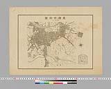
豊橋市街図 縮尺一万二千分一
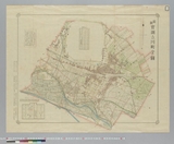
最新実測立川町全図

Motor road network, Japan
![Chinkaiwan Yōsai Katoku hōmen ichimanbun no ichi zu [cartographic material]](https://stacks.stanford.edu/image/iiif/ts181gj7766%2Fts181gj7766_00_0001/full/!200,200/0/default.jpg)
Chinkaiwan Yōsai Katoku hōmen ichimanbun no ichi zu [cartographic material]
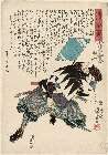
「誠忠義士伝」 「九」「小野寺重内秀知」

「文久三年みつのとのい 月々の大小朔日のゑとを句中に置」
Last Updated: 2020-04-17
Uploaded: 2021-09-21