

Saipantō oyobi Teniantō

南洋サイパン島風景 マンゴロープ樹

南洋サイパン島風景 サドクターシ附近

南洋サイパン島風景 支庁桟橋

南洋サイパン島風景 カナベーラ大藤ノ実
![Niman-gosenbun no ichi chikeizu Saipantō [cartographic material]](https://stacks.stanford.edu/image/iiif/vz287bn1488%2Fvz287bn1488_00_0001/full/!200,200/0/default.jpg)
Niman-gosenbun no ichi chikeizu Saipantō [cartographic material]

南洋サイパン島風景 ガラパン街2丁目通り

Path-Path to the cliff where Japanese committed suicide after the American landings of WWⅡ, Saipan
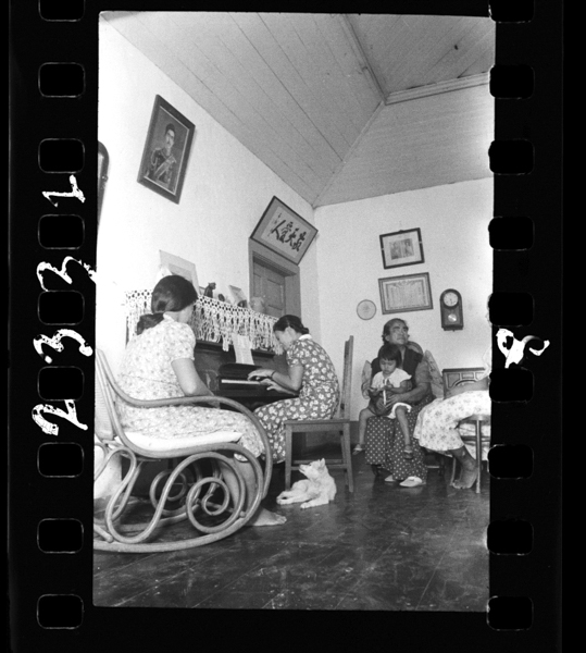
Shouwa16nen2gatsu、paraotoukasaipantoude。chamorozokunokazoku。nanyoushotouhadaiichijitaisengo、nihonnoinintouchiryoutonarijuuminnokoukokuminkagasusumerareta。kabenihatennou、kougounoshashingamieru。

篠つく猛雨を衝き両艇サイパン島に着 : 母国の新鋭機を迎え官民歓呼 : 海軍の南洋征空成る

東京・サイパン島間定期航空を断行 : 今夏から一日半の旅実現 : クリッパーに連絡か : 海の生命線へ新空路

柏島-沖の島母島

Miyajima, Hiroshima

五島列島
ejimaikushima

田島半島

Zaimoku Island, Matsushima

Fukushima-shi, Fukushima

大島至鳥島

沖の島(母島)

沖の島(母島)
![肥前国平戸島生[月]島黒島大島度島沿海之図](https://rmda.kulib.kyoto-u.ac.jp/iiif/RB00014992/RB00014992_00001_0.ptif/full/200,/0/default.jpg)
肥前国平戸島生[月]島黒島大島度島沿海之図

〓
Island

Rice areas in Japan

Jūmanbunnoichi Guamutō fukin

Ryōtō Kaiwan : Daitzu Shan to Fuchou Chao

Durville Island and Approaches

Celebes - West Coast : Cape William to Tandyung Karang

Plans of Anchorages in Witu Islands

New Guinea - N. E. Coast. C. Ward Hunt to C. Nelson

Straits between Sumbawa, Flores and Sumba

Gomanbun no ichi Nikobaru Shotō rikukai hengōzu

Central Japan (central and northern Honshū) distribution of population

Guide to Tokyo City

Approach to West Coast of Gazelle Peninsula

Eastern Portion of Flores to Lomblem

Pacific Ocean, Approaches to south east part of New Guinea

Central Portion of Sumbawa with Pulo Tenga Islands

Eastern Archipelago : Flores Sea. Tana Jampea and Adjacent Islands

Togian Isles to Peleng Strait

North Pacific Ocean : Eastern Part of Hawaiin Islands
![Yokohama : [base map showing political divisions]](https://stacks.stanford.edu/image/iiif/hg765ms3579%2Fhg765ms3579_00_0001/full/!200,200/0/default.jpg)
Yokohama : [base map showing political divisions]

Carta General para las Navegaciones a la India Oriental por el Mar del Sur y el Grande Oceano que ...

Hermit Islands

Yōzu (kūchū shashin sokuryō) Rusontō jūmanbun no ichi zu

Japan, acreage of rice by prefectures, 1939. Japan, acreage of wheat by prefectures, 1939
![[Russian Map of Northeastern Asia, Japan, Korea, China, Alaska, etc.] ( Summary map of hydrographi...](https://stacks.stanford.edu/image/iiif/pj697kr2558%2F35405/full/!200,200/0/default.jpg)
[Russian Map of Northeastern Asia, Japan, Korea, China, Alaska, etc.] ( Summary map of hydrographi...
Last Updated: 2020-04-17
Uploaded: 2021-09-21